Winneba elevation
Winneba (Central), Ghana elevation is 25 meters and Winneba elevation in feet is 82 ft above sea level [src 1]. Winneba is a populated place (feature code) with elevation that is 145 meters (476 ft) smaller than average city elevation in Ghana.
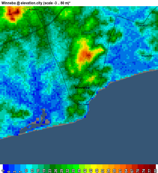
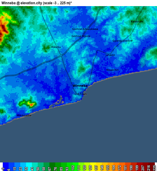
Below is the Elevation map of Winneba, which displays elevation range with different colors. Scale of the first map is from -3 to 80 m (-10 to 262 ft) with average elevation of 17.3 meters (=57 ft) [note 1]
These maps also provides idea of topography and contour of this city, they are displayed at different zoom levels. More info about maps, scale and edge coordinates you can find below images.
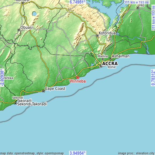
| \ | Map #1 | Map #2 | Topo.Map |
| Scale [m] | -3..80 m | -3..225 m | × |
| Scale [ft] | -10..262 ft | -10..738 ft | × |
| Average | 17.3 m = 57 ft | 29.2 m = 96 ft | × |
| Width | 9.73 km = 6 mi | 19.46 km = 12.1 mi | 311.3 km = 193.4 mi |
| Height | 9.73 km = 6 mi | 19.46 km = 12.1 mi | 311.4 km = 193.5 mi |
| ↑Max Latitude | 5.394882° | 5.438631° | 6.74951° |
| Latitude at center | 5.35113° | 5.35113° | 5.35113° |
| ↓Min Latitude | 5.307375° | 5.263616° | 3.94954° |
| ← Min Longitude | -0.667075° | -0.711021° | -2.02938° |
| Longitude center | -0.62313° | -0.62313° | -0.62313° |
| →Max Longitude | -0.579185° | -0.535239° | 0.78312° |
Nearby cities:
Cities around Winneba sort by population:
• Accra elevation 33 m
52.4 km,  64°
64°
• Atsiaman 45 m
50.5 km,  40°
40°
• Medina Estates 86 m
61.8 km, 55°
• Swedru 74 m
22.4 km,  337°
337°
• Dome 35 m
54.2 km,  52°
52°
• Gbawe 31 m
42.8 km, 54°
• Nsawam 61 m
59.2 km,  30°
30°
• Kasoa 18 m
30.6 km, 48°
• Asamankese 147 m
56.8 km,  355°
355°
• Saltpond 14 m
50.9 km,  251°
251°
• Apam 12 m
14.6 km,  239°
239°
• Mumford 33 m
18 km, 236°
Multilingual:
 En español:
Winneba elevación 25 m.
 En France:
Winneba élévation 25 m.


Sources and notes:
- [note 1] Map square and city borders are not equal. Map elevation data is calculated only from area inside that square.
- [src 1] Elevation data from geonames database provided with same terms of usage.
- [src 2] The elevation map of Winneba is generated using elevation data from NASA's 3 arcsec (90m) resolution SRTM data.
- [src 3] Base (background) map © OpenStreetMap contributors tiles are generated by Geofabrik and OpenTopoMap.
Copyright & License:
This Winneba Elevation Map is licensed under CC BY-SA. You may reuse any part from this page, if you give a proper credit by linking to this URL:
 More info on terms of use page.