Bechem elevation
Bechem (Brong-Ahafo, Tano South), Ghana elevation is 296 meters and Bechem elevation in feet is 971 ft above sea level [src 1]. Bechem is a seat of a second-order administrative division (feature code) with elevation that is 126 meters (413 ft) bigger than average city elevation in Ghana.
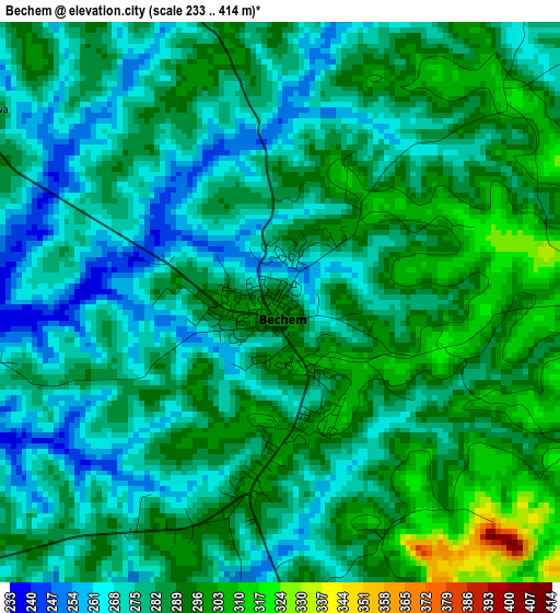
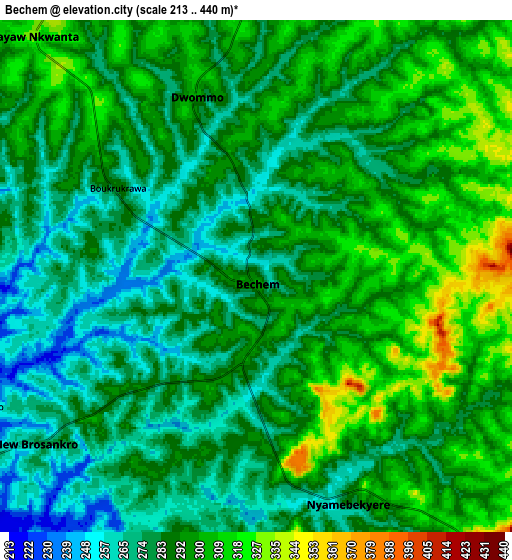
Below is the Elevation map of Bechem, which displays elevation range with different colors. Scale of the first map is from 233 to 414 m (764 to 1358 ft) with average elevation of 282.5 meters (=927 ft) [note 1]
These maps also provides idea of topography and contour of this city, they are displayed at different zoom levels. More info about maps, scale and edge coordinates you can find below images.
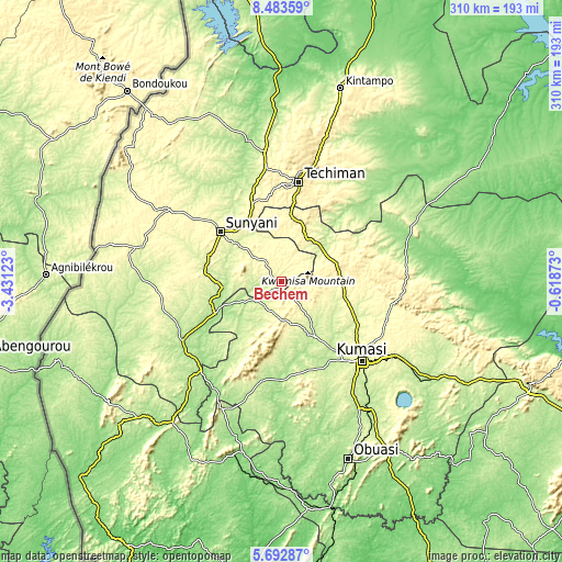
| \ | Map #1 | Map #2 | Topo.Map |
| Scale [m] | 233..414 m | 213..440 m | × |
| Scale [ft] | 764..1358 ft | 699..1444 ft | × |
| Average | 282.5 m = 927 ft | 288.5 m = 947 ft | × |
| Width | 9.7 km = 6 mi | 19.4 km = 12.1 mi | 310.3 km = 192.8 mi |
| Height | 9.7 km = 6 mi | 19.4 km = 12.1 mi | 310.3 km = 192.8 mi |
| ↑Max Latitude | 7.133947° | 7.17755° | 8.48359° |
| Latitude at center | 7.09034° | 7.09034° | 7.09034° |
| ↓Min Latitude | 7.046729° | 7.003113° | 5.69287° |
| ← Min Longitude | -2.068925° | -2.112871° | -3.43123° |
| Longitude center | -2.02498° | -2.02498° | -2.02498° |
| →Max Longitude | -1.981035° | -1.937089° | -0.61873° |
Nearby cities:
Cities around Bechem sort by population:
• Kumasi elevation 270 m
62.9 km,  135°
135°
• Ejura 224 m
80.7 km,  66°
66°
• Sunyani 298 m
43.3 km,  309°
309°
• Techiman 390 m
55.7 km,  9°
9°
• Berekum 330 m
73.7 km,  303°
303°
• Tafo 291 m
60.4 km,  131°
131°
• Mampong 395 m
69 km,  92°
92°
• Wenchi 308 m
72.7 km,  353°
353°
• Bibiani 223 m
76.9 km,  205°
205°
• Duayaw-Nkwanta 304 m
12.5 km,  318°
318°
• Bekwai 231 m
86.4 km,  145°
145°
• Mamponteng 274 m
65.8 km, 127°
Multilingual:
 En español:
Bechem elevación 296 m.
 En France:
Bechem élévation 296 m.


Sources and notes:
- [note 1] Map square and city borders are not equal. Map elevation data is calculated only from area inside that square.
- [src 1] Elevation data from geonames database provided with same terms of usage.
- [src 2] The elevation map of Bechem is generated using elevation data from NASA's 3 arcsec (90m) resolution SRTM data.
- [src 3] Base (background) map © OpenStreetMap contributors tiles are generated by Geofabrik and OpenTopoMap.
Copyright & License:
This Bechem Elevation Map is licensed under CC BY-SA. You may reuse any part from this page, if you give a proper credit by linking to this URL:
 More info on terms of use page.