Techiman elevation
Techiman (Brong-Ahafo), Ghana elevation is 390 meters and Techiman elevation in feet is 1280 ft above sea level [src 1]. Techiman is a populated place (feature code) with elevation that is 220 meters (722 ft) bigger than average city elevation in Ghana.
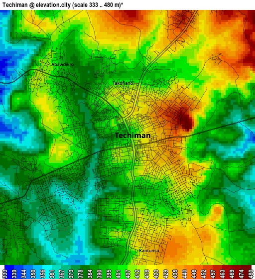
Below is the Elevation map of Techiman, which displays elevation range with different colors. Scale of the first map is from 333 to 480 m (1093 to 1575 ft) with average elevation of 401 meters (=1316 ft) [note 1]
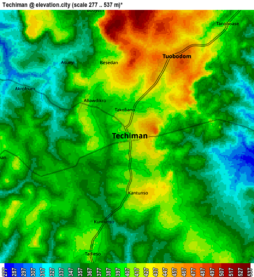
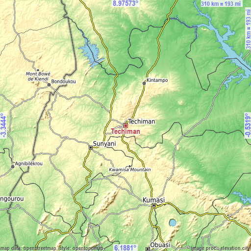
These maps also provides idea of topography and contour of this city, they are displayed at different zoom levels. More info about maps, scale and edge coordinates you can find below images.
| \ | Map #1 | Map #2 | Topo.Map |
| Scale [m] | 333..480 m | 277..537 m | × |
| Scale [ft] | 1093..1575 ft | 909..1762 ft | × |
| Average | 401 m = 1316 ft | 386 m = 1266 ft | × |
| Width | 9.69 km = 6 mi | 19.37 km = 12 mi | 310 km = 192.6 mi |
| Height | 9.69 km = 6 mi | 19.37 km = 12 mi | 310 km = 192.6 mi |
| ↑Max Latitude | 7.627729° | 7.671283° | 8.97573° |
| Latitude at center | 7.58417° | 7.58417° | 7.58417° |
| ↓Min Latitude | 7.540607° | 7.497039° | 6.1881° |
| ← Min Longitude | -1.982095° | -2.026041° | -3.3444° |
| Longitude center | -1.93815° | -1.93815° | -1.93815° |
| →Max Longitude | -1.894205° | -1.850259° | -0.5319° |
Nearby cities:
Cities around Techiman sort by population:
• Kumasi elevation 270 m
105.4 km,  160°
160°
• Japekrom 267 m
93.4 km,  269°
269°
• Ejura 224 m
67.9 km,  108°
108°
• Sunyani 298 m
50.7 km,  237°
237°
• Berekum 330 m
72.7 km,  258°
258°
• Tafo 291 m
101.3 km, 159°
• Kintampo 343 m
57.3 km,  23°
23°
• Mampong 395 m
83 km,  134°
134°
• Wenchi 308 m
25.2 km,  313°
313°
• Bechem 296 m
55.7 km,  189°
189°
• Duayaw-Nkwanta 304 m
48.9 km,  201°
201°
• Mamponteng 274 m
103.8 km, 155°
Multilingual:
 En español:
Techiman elevación 390 m.
 En France:
Techiman élévation 390 m.
 Auf Deutsch:
Techiman höhe über dem Meeresspiegel ist 390 m.

Sources and notes:
- [note 1] Map square and city borders are not equal. Map elevation data is calculated only from area inside that square.
- [src 1] Elevation data from geonames database provided with same terms of usage.
- [src 2] The elevation map of Techiman is generated using elevation data from NASA's 3 arcsec (90m) resolution SRTM data.
- [src 3] Base (background) map © OpenStreetMap contributors tiles are generated by Geofabrik and OpenTopoMap.
Copyright & License:
This Techiman Elevation Map is licensed under CC BY-SA. You may reuse any part from this page, if you give a proper credit by linking to this URL:
 More info on terms of use page.