Dioknisi elevation
Dioknisi (Ajaria), Georgia elevation is 1086 meters and Dioknisi elevation in feet is 3563 ft above sea level [src 1]. Dioknisi is a populated place (feature code) with elevation that is 546 meters (1791 ft) bigger than average city elevation in Georgia.
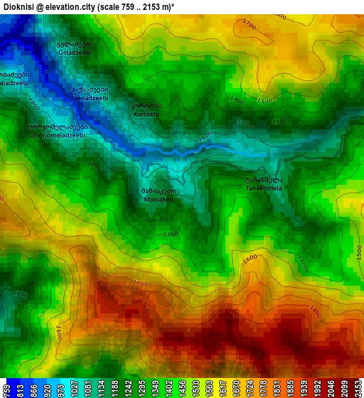
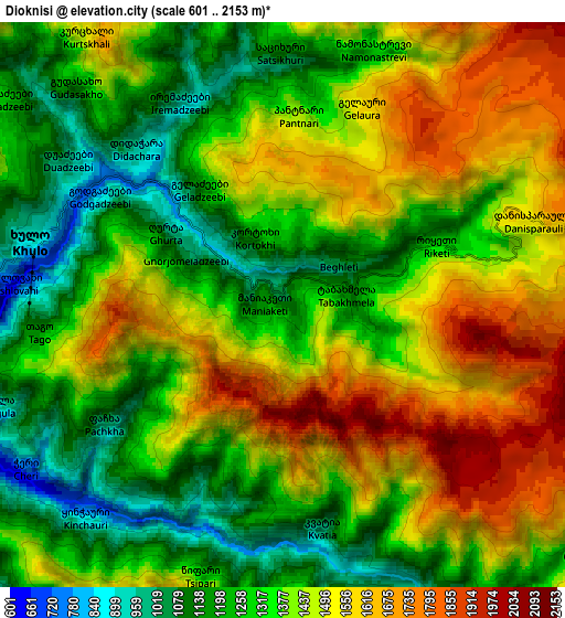
Below is the Elevation map of Dioknisi, which displays elevation range with different colors. Scale of the first map is from 759 to 2153 m (2490 to 7064 ft) with average elevation of 1440.6 meters (=4726 ft) [note 1]
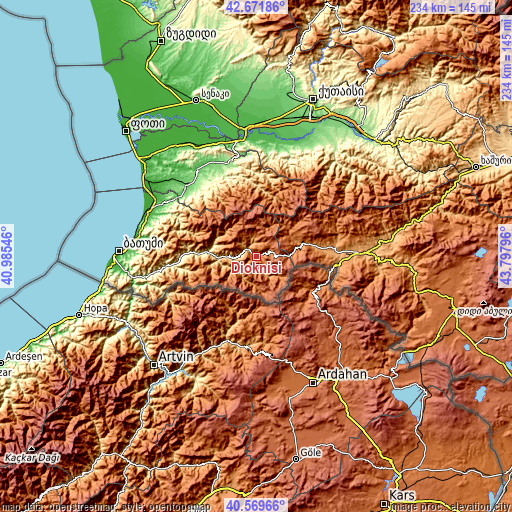
These maps also provides idea of topography and contour of this city, they are displayed at different zoom levels. More info about maps, scale and edge coordinates you can find below images.
| \ | Map #1 | Map #2 | Topo.Map |
| Scale [m] | 759..2153 m | 601..2153 m | × |
| Scale [ft] | 2490..7064 ft | 1972..7064 ft | × |
| Average | 1440.6 m = 4726 ft | 1391 m = 4564 ft | × |
| Width | 7.3 km = 4.5 mi | 14.61 km = 9.1 mi | 233.7 km = 145.2 mi |
| Height | 7.3 km = 4.5 mi | 14.61 km = 9.1 mi | 233.7 km = 145.2 mi |
| ↑Max Latitude | 41.662169° | 41.694991° | 42.67186° |
| Latitude at center | 41.62933° | 41.62933° | 41.62933° |
| ↓Min Latitude | 41.596474° | 41.563602° | 40.56966° |
| ← Min Longitude | 42.347765° | 42.303819° | 40.98546° |
| Longitude center | 42.39171° | 42.39171° | 42.39171° |
| →Max Longitude | 42.435655° | 42.479601° | 43.79796° |
Nearby cities:
Cities around Dioknisi sort by population:
• Ozurgeti elevation 84 m
45.8 km,  315°
315°
• Akhaltsikhe 984 m
49.1 km,  88°
88°
• Vale 1172 m
40 km, 92°
• Vani 70 m
51.6 km,  12°
12°
• Akhaldaba 748 m
20.1 km,  277°
277°
• Naruja 144 m
47.6 km,  310°
310°
• Ochkhamuri 22 m
51.5 km,  299°
299°
• Adigeni 1253 m
26.2 km,  77°
77°
• Abastumani 1203 m
38.7 km, 77°
• Khulo 1044 m
7.5 km, 282°
• Shuakhevi 572 m
16.7 km,  270°
270°
• Keda 305 m
37.7 km, 265°
Multilingual:
 En español:
Dioknisi elevación 1086 m.
 En France:
Dioknisi élévation 1086 m.
 Auf Deutsch:
Dioknisi höhe über dem Meeresspiegel ist 1086 m.

Sources and notes:
- [note 1] Map square and city borders are not equal. Map elevation data is calculated only from area inside that square.
- [src 1] Elevation data from geonames database provided with same terms of usage.
- [src 2] The elevation map of Dioknisi is generated using elevation data from NASA's 3 arcsec (90m) resolution SRTM data.
- [src 3] Base (background) map © OpenStreetMap contributors tiles are generated by Geofabrik and OpenTopoMap.
Copyright & License:
This Dioknisi Elevation Map is licensed under CC BY-SA. You may reuse any part from this page, if you give a proper credit by linking to this URL:
 More info on terms of use page.