Burngreave elevation
Burngreave (England, Sheffield), United Kingdom elevation is 65 meters and Burngreave elevation in feet is 213 ft above sea level [src 1]. Burngreave is a populated place (feature code) with elevation that is 7 meters (23 ft) smaller than average city elevation in United Kingdom.
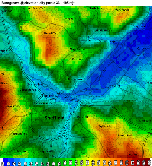
Below is the Elevation map of Burngreave, which displays elevation range with different colors. Scale of the first map is from 33 to 195 m (108 to 640 ft) with average elevation of 92 meters (=302 ft) [note 1]
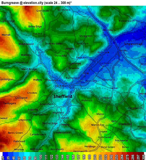
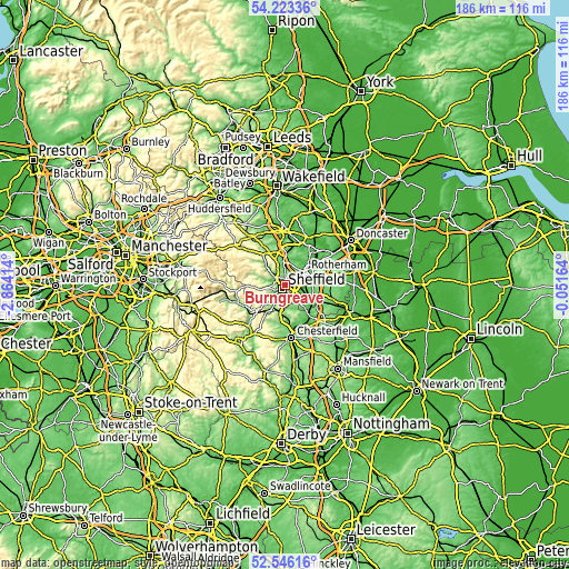
These maps also provides idea of topography and contour of this city, they are displayed at different zoom levels. More info about maps, scale and edge coordinates you can find below images.
| \ | Map #1 | Map #2 | Topo.Map |
| Scale [m] | 33..195 m | 24..308 m | × |
| Scale [ft] | 108..640 ft | 79..1010 ft | × |
| Average | 92 m = 302 ft | 121.1 m = 397 ft | × |
| Width | 5.83 km = 3.6 mi | 11.66 km = 7.2 mi | 186.5 km = 115.9 mi |
| Height | 5.83 km = 3.6 mi | 11.66 km = 7.2 mi | 186.5 km = 115.9 mi |
| ↑Max Latitude | 53.419218° | 53.445399° | 54.22336° |
| Latitude at center | 53.39302° | 53.39302° | 53.39302° |
| ↓Min Latitude | 53.366806° | 53.340577° | 52.54616° |
| ← Min Longitude | -1.501835° | -1.545781° | -2.86414° |
| Longitude center | -1.45789° | -1.45789° | -1.45789° |
| →Max Longitude | -1.413945° | -1.369999° | -0.05164° |
Nearby cities:
Cities around Burngreave sort by population:
• Sheffield elevation 75 m
1.2 km,  205°
205°
• Rotherham 41 m
7.9 km,  58°
58°
• Chapeltown 111 m
8.1 km,  353°
353°
• Dronfield 159 m
10.2 km,  186°
186°
• Oughtibridge 98 m
7.2 km,  311°
311°
• Treeton 59 m
7.1 km,  96°
96°
• Catcliffe 46 m
6.4 km,  89°
89°
• Wentworth 115 m
9.9 km,  16°
16°
• Ulley 112 m
10.4 km, 96°
• Bradfield 223 m
9.8 km,  285°
285°
• Whiston 66 m
9.6 km,  79°
79°
• Orgreave -30 m
6.1 km, 100°
Multilingual:
 En español:
Burngreave elevación 65 m.
 En France:
Burngreave élévation 65 m.
 Auf Deutsch:
Burngreave höhe über dem Meeresspiegel ist 65 m.

Sources and notes:
- [note 1] Map square and city borders are not equal. Map elevation data is calculated only from area inside that square.
- [src 1] Elevation data from geonames database provided with same terms of usage.
- [src 2] The elevation map of Burngreave is generated using elevation data from NASA's 3 arcsec (90m) resolution SRTM data.
- [src 3] Base (background) map © OpenStreetMap contributors tiles are generated by Geofabrik and OpenTopoMap.
Copyright & License:
This Burngreave Elevation Map is licensed under CC BY-SA. You may reuse any part from this page, if you give a proper credit by linking to this URL:
 More info on terms of use page.