Rotherham elevation
Rotherham (England), United Kingdom elevation is 41 meters and Rotherham elevation in feet is 135 ft above sea level [src 1]. Rotherham is a seat of a second-order administrative division (feature code) with elevation that is 31 meters (102 ft) smaller than average city elevation in United Kingdom.
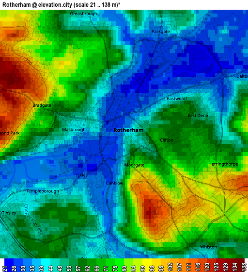
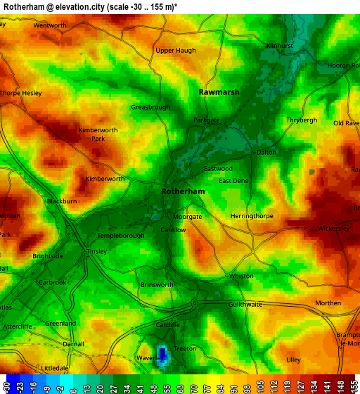
Below is the Elevation map of Rotherham, which displays elevation range with different colors. Scale of the first map is from 21 to 138 m (69 to 453 ft) with average elevation of 57.8 meters (=190 ft) [note 1]
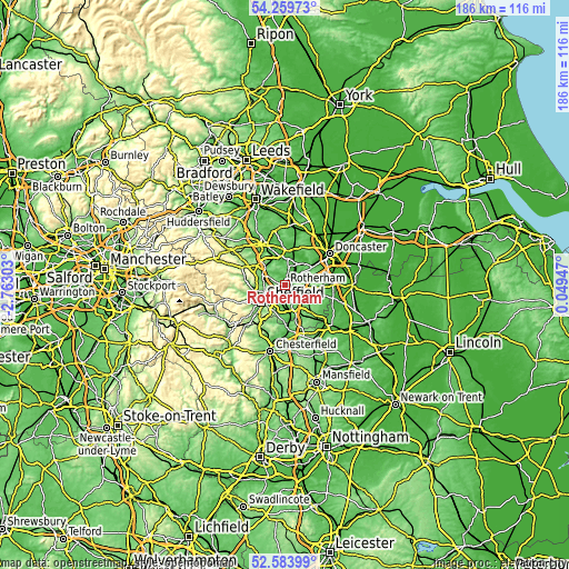
These maps also provides idea of topography and contour of this city, they are displayed at different zoom levels. More info about maps, scale and edge coordinates you can find below images.
| \ | Map #1 | Map #2 | Topo.Map |
| Scale [m] | 21..138 m | -30..155 m | × |
| Scale [ft] | 69..453 ft | -98..509 ft | × |
| Average | 57.8 m = 190 ft | 72.9 m = 239 ft | × |
| Width | 5.82 km = 3.6 mi | 11.65 km = 7.2 mi | 186.3 km = 115.8 mi |
| Height | 5.82 km = 3.6 mi | 11.64 km = 7.2 mi | 186.3 km = 115.8 mi |
| ↑Max Latitude | 53.456295° | 53.482453° | 54.25973° |
| Latitude at center | 53.43012° | 53.43012° | 53.43012° |
| ↓Min Latitude | 53.403929° | 53.377722° | 52.58399° |
| ← Min Longitude | -1.400725° | -1.444671° | -2.76303° |
| Longitude center | -1.35678° | -1.35678° | -1.35678° |
| →Max Longitude | -1.312835° | -1.268889° | 0.04947° |
Nearby cities:
Cities around Rotherham sort by population:
• Burngreave elevation 65 m
7.9 km,  238°
238°
• Rawmarsh 81 m
3.5 km,  13°
13°
• Wath upon Dearne 35 m
8.1 km, 5°
• Mexborough 28 m
8.3 km,  30°
30°
• Treeton 59 m
5 km,  176°
176°
• Catcliffe 46 m
4.1 km, 184°
• Hellaby 105 m
7.7 km,  96°
96°
• Wentworth 115 m
6.6 km,  324°
324°
• Ulley 112 m
6.5 km,  145°
145°
• Bramley 132 m
6.2 km, 104°
• Orgreave -30 m
5.2 km,  187°
187°
• Whiston 66 m
3.7 km,  131°
131°
Multilingual:
 En español:
Rotherham elevación 41 m.
 En France:
Rotherham élévation 41 m.
 Auf Deutsch:
Rotherham höhe über dem Meeresspiegel ist 41 m.

Sources and notes:
- [note 1] Map square and city borders are not equal. Map elevation data is calculated only from area inside that square.
- [src 1] Elevation data from geonames database provided with same terms of usage.
- [src 2] The elevation map of Rotherham is generated using elevation data from NASA's 3 arcsec (90m) resolution SRTM data.
- [src 3] Base (background) map © OpenStreetMap contributors tiles are generated by Geofabrik and OpenTopoMap.
Copyright & License:
This Rotherham Elevation Map is licensed under CC BY-SA. You may reuse any part from this page, if you give a proper credit by linking to this URL:
 More info on terms of use page.