Heywood elevation
Heywood (England, Manchester), United Kingdom elevation is 121 meters and Heywood elevation in feet is 397 ft above sea level [src 1]. Heywood is a section of populated place (feature code) with elevation that is 49 meters (161 ft) bigger than average city elevation in United Kingdom.
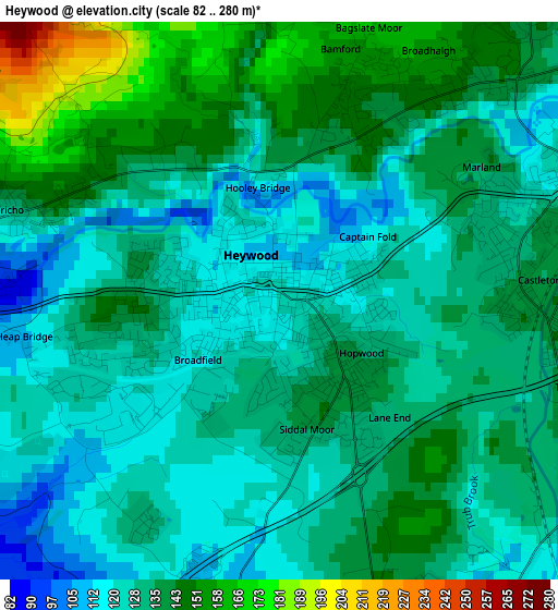
Below is the Elevation map of Heywood, which displays elevation range with different colors. Scale of the first map is from 82 to 280 m (269 to 919 ft) with average elevation of 133.2 meters (=437 ft) [note 1]
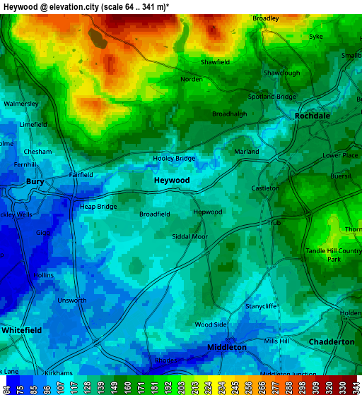
These maps also provides idea of topography and contour of this city, they are displayed at different zoom levels. More info about maps, scale and edge coordinates you can find below images.
| \ | Map #1 | Map #2 | Topo.Map |
| Scale [m] | 82..280 m | 64..341 m | × |
| Scale [ft] | 269..919 ft | 210..1119 ft | × |
| Average | 133.2 m = 437 ft | 144.3 m = 473 ft | × |
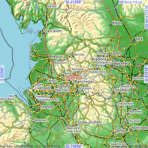
| Width | 5.8 km = 3.6 mi | 11.6 km = 7.2 mi | 185.6 km = 115.3 mi |
| Height | 5.8 km = 3.6 mi | 11.6 km = 7.2 mi | 185.6 km = 115.3 mi |
| ↑Max Latitude | 53.618525° | 53.644583° | 54.41888° |
| Latitude at center | 53.59245° | 53.59245° | 53.59245° |
| ↓Min Latitude | 53.566359° | 53.540253° | 52.74954° |
| ← Min Longitude | -2.263355° | -2.307301° | -3.62566° |
| Longitude center | -2.21941° | -2.21941° | -2.21941° |
| →Max Longitude | -2.175465° | -2.131519° | -0.81316° |
Nearby cities:
Cities around Heywood sort by population:
• Rochdale elevation 127 m
5.1 km,  56°
56°
• Bury 93 m
5.4 km,  278°
278°
• Middleton 87 m
4.9 km,  164°
164°
• Radcliffe 76 m
7.7 km,  243°
243°
• Prestwich 97 m
7.8 km,  212°
212°
• Whitefield 124 m
7.1 km,  228°
228°
• Royton 160 m
7.1 km,  115°
115°
• Milnrow 148 m
7.3 km,  73°
73°
• Crumpsall 80 m
8.4 km,  191°
191°
• Blackley 81 m
8.3 km,  177°
177°
• Tottington 150 m
8.3 km,  286°
286°
• Whitworth 222 m
7.6 km,  21°
21°
Multilingual:
 En español:
Heywood elevación 121 m.
 En France:
Heywood élévation 121 m.


Sources and notes:
- [note 1] Map square and city borders are not equal. Map elevation data is calculated only from area inside that square.
- [src 1] Elevation data from geonames database provided with same terms of usage.
- [src 2] The elevation map of Heywood is generated using elevation data from NASA's 3 arcsec (90m) resolution SRTM data.
- [src 3] Base (background) map © OpenStreetMap contributors tiles are generated by Geofabrik and OpenTopoMap.
Copyright & License:
This Heywood Elevation Map is licensed under CC BY-SA. You may reuse any part from this page, if you give a proper credit by linking to this URL:
 More info on terms of use page.