Astwood elevation
Astwood (England, Milton Keynes), United Kingdom elevation is 89 meters and Astwood elevation in feet is 292 ft above sea level [src 1]. Astwood is a seat of a third-order administrative division (feature code) with elevation that is 17 meters (56 ft) bigger than average city elevation in United Kingdom.
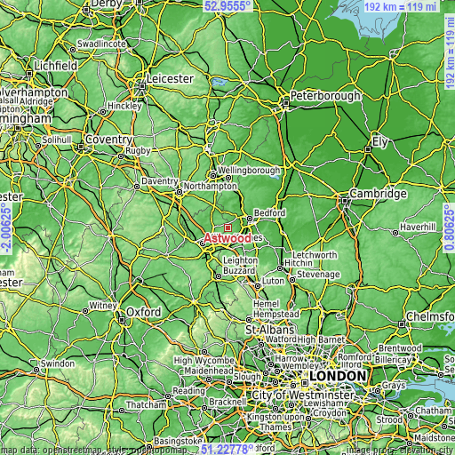
Below is the Elevation map of Astwood, which displays elevation range with different colors. Scale of the first map is from 44 to 115 m (144 to 377 ft) with average elevation of 88.7 meters (=291 ft) [note 1]
These maps also provides idea of topography and contour of this city, they are displayed at different zoom levels. More info about maps, scale and edge coordinates you can find below images.

| \ | Map #1 | Topo.Map |
| Scale [m] | 44..115 m | × |
| Scale [ft] | 144..377 ft | × |
| Average | 88.7 m = 291 ft | × |
| Width | 6 km = 3.7 mi | 192.1 km = 119.4 mi |
| Height | 6 km = 3.7 mi | 192.1 km = 119.4 mi |
| ↑Max Latitude | 52.126987° | 52.9555° |
| Latitude at center | 52.1° | 52.1° |
| ↓Min Latitude | 52.072997° | 51.22778° |
| ← Min Longitude | -0.643945° | -2.00625° |
| Longitude center | -0.6° | -0.6° |
| →Max Longitude | -0.556055° | 0.80625° |
Nearby cities:
Cities around Astwood sort by population:
• Kempston Hardwick elevation 37 m
7 km,  99°
99°
• Kempston 32 m
7 km,  75°
75°
• Cranfield 112 m
3.5 km,  189°
189°
• Bromham 38 m
7 km,  44°
44°
• Wootton 48 m
4.5 km, 96°
• Marston Moretaine 44 m
5.3 km,  139°
139°
• Stewartby 42 m
6.7 km,  119°
119°
• Lidlington 63 m
7.1 km,  156°
156°
• Sherington 76 m
6.9 km,  280°
280°
• Stagsden 62 m
4.1 km,  33°
33°
• Moulsoe 81 m
6.1 km,  235°
235°
• Chicheley 82 m
5.9 km,  273°
273°
Multilingual:
 En español:
Astwood elevación 89 m.
 En France:
Astwood élévation 89 m.


Sources and notes:
- [note 1] Map square and city borders are not equal. Map elevation data is calculated only from area inside that square.
- [src 1] Elevation data from geonames database provided with same terms of usage.
- [src 2] The elevation map of Astwood is generated using elevation data from NASA's 3 arcsec (90m) resolution SRTM data.
- [src 3] Base (background) map © OpenStreetMap contributors tiles are generated by Geofabrik and OpenTopoMap.
Copyright & License:
This Astwood Elevation Map is licensed under CC BY-SA. You may reuse any part from this page, if you give a proper credit by linking to this URL:
 More info on terms of use page.