Bagillt elevation
Bagillt (Wales, County of Flintshire), United Kingdom elevation is 22 meters and Bagillt elevation in feet is 72 ft above sea level [src 1]. Bagillt is a populated place (feature code) with elevation that is 50 meters (164 ft) smaller than average city elevation in United Kingdom.
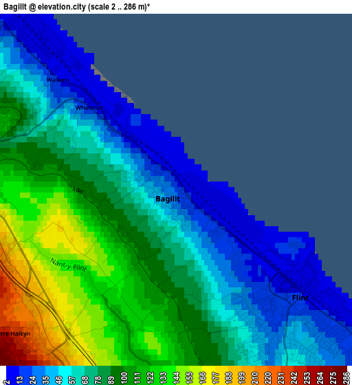
Below is the Elevation map of Bagillt, which displays elevation range with different colors. Scale of the first map is from 2 to 286 m (7 to 938 ft) with average elevation of 81.4 meters (=267 ft) [note 1]
These maps also provides idea of topography and contour of this city, they are displayed at different zoom levels. More info about maps, scale and edge coordinates you can find below images.
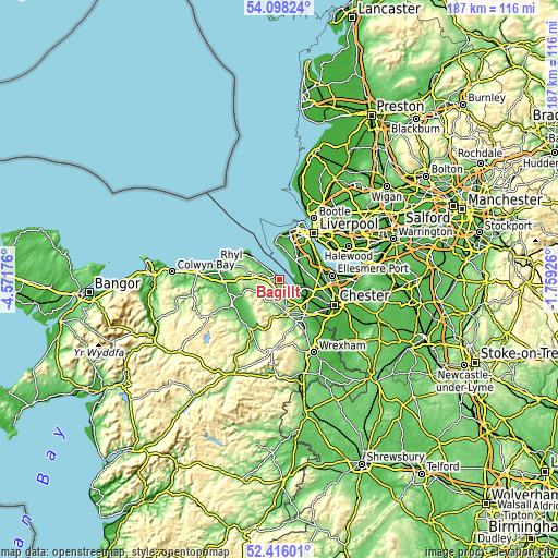
| \ | Map #1 | Topo.Map |
| Scale [m] | 2..286 m | × |
| Scale [ft] | 7..938 ft | × |
| Average | 81.4 m = 267 ft | × |
| Width | 5.84 km = 3.6 mi | 187 km = 116.2 mi |
| Height | 5.85 km = 3.6 mi | 187 km = 116.2 mi |
| ↑Max Latitude | 53.291676° | 54.09824° |
| Latitude at center | 53.2654° | 53.2654° |
| ↓Min Latitude | 53.239108° | 52.41601° |
| ← Min Longitude | -3.209455° | -4.57176° |
| Longitude center | -3.16551° | -3.16551° |
| →Max Longitude | -3.121565° | -1.75926° |
Nearby cities:
Cities around Bagillt sort by population:
• Deeside elevation 28 m
11.1 km,  130°
130°
• Heswall 88 m
8.3 km,  33°
33°
• Flint 29 m
3.2 km,  135°
135°
• Neston 49 m
7.9 km,  75°
75°
• Mold 115 m
11.1 km,  171°
171°
• Holywell 140 m
4.3 km,  283°
283°
• Greenfield 55 m
3.9 km,  300°
300°
• Mostyn 62 m
8.6 km,  307°
307°
• Northop 102 m
6.9 km,  161°
161°
• Queensferry 25 m
11.4 km, 129°
• Whitford 210 m
8.1 km, 284°
• Halkyn 271 m
4.7 km,  200°
200°
Multilingual:
 En español:
Bagillt elevación 22 m.
 En France:
Bagillt élévation 22 m.


Sources and notes:
- [note 1] Map square and city borders are not equal. Map elevation data is calculated only from area inside that square.
- [src 1] Elevation data from geonames database provided with same terms of usage.
- [src 2] The elevation map of Bagillt is generated using elevation data from NASA's 3 arcsec (90m) resolution SRTM data.
- [src 3] Base (background) map © OpenStreetMap contributors tiles are generated by Geofabrik and OpenTopoMap.
Copyright & License:
This Bagillt Elevation Map is licensed under CC BY-SA. You may reuse any part from this page, if you give a proper credit by linking to this URL:
 More info on terms of use page.