Balloch elevation
Balloch (Scotland, West Dunbartonshire), United Kingdom elevation is 14 meters and Balloch elevation in feet is 46 ft above sea level [src 1]. Balloch is a populated place (feature code) with elevation that is 58 meters (190 ft) smaller than average city elevation in United Kingdom.
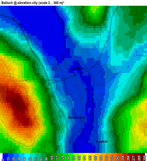
Below is the Elevation map of Balloch, which displays elevation range with different colors. Scale of the first map is from 2 to 300 m (7 to 984 ft) with average elevation of 83.6 meters (=274 ft) [note 1]
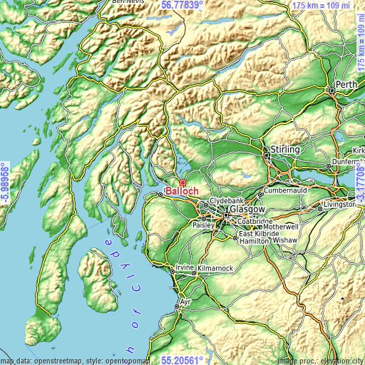
These maps also provides idea of topography and contour of this city, they are displayed at different zoom levels. More info about maps, scale and edge coordinates you can find below images.
| \ | Map #1 | Topo.Map |
| Scale [m] | 2..300 m | × |
| Scale [ft] | 7..984 ft | × |
| Average | 83.6 m = 274 ft | × |
| Width | 5.46 km = 3.4 mi | 174.9 km = 108.7 mi |
| Height | 5.46 km = 3.4 mi | 174.9 km = 108.7 mi |
| ↑Max Latitude | 56.024566° | 56.77839° |
| Latitude at center | 56° | 56° |
| ↓Min Latitude | 55.975418° | 55.20561° |
| ← Min Longitude | -4.627275° | -5.98958° |
| Longitude center | -4.58333° | -4.58333° |
| →Max Longitude | -4.539385° | -3.17708° |
Nearby cities:
Cities around Balloch sort by population:
• Vale of Leven elevation 9 m
3.2 km,  175°
175°
• Dumbarton 4 m
6.2 km,  172°
172°
• Port Glasgow 7 m
9.8 km,  222°
222°
• Helensburgh 27 m
8.9 km,  274°
274°
• Bonhill 59 m
2.6 km,  152°
152°
• Alexandria 23 m
0.7 km,  195°
195°
• Old Kilpatrick 26 m
11.7 km,  137°
137°
• Bishopton 31 m
11.1 km, 154°
• Kilmacolm 101 m
12 km,  192°
192°
• Renton 12 m
3.1 km, 180°
• Cardross 8 m
6.1 km,  225°
225°
• Rhu 56 m
11.5 km,  279°
279°
Multilingual:
 En español:
Balloch elevación 14 m.
 En France:
Balloch élévation 14 m.


Sources and notes:
- [note 1] Map square and city borders are not equal. Map elevation data is calculated only from area inside that square.
- [src 1] Elevation data from geonames database provided with same terms of usage.
- [src 2] The elevation map of Balloch is generated using elevation data from NASA's 3 arcsec (90m) resolution SRTM data.
- [src 3] Base (background) map © OpenStreetMap contributors tiles are generated by Geofabrik and OpenTopoMap.
Copyright & License:
This Balloch Elevation Map is licensed under CC BY-SA. You may reuse any part from this page, if you give a proper credit by linking to this URL:
 More info on terms of use page.