Kilmacolm elevation
Kilmacolm (Scotland, Inverclyde), United Kingdom elevation is 101 meters and Kilmacolm elevation in feet is 331 ft above sea level [src 1]. Kilmacolm is a populated place (feature code) with elevation that is 29 meters (95 ft) bigger than average city elevation in United Kingdom.
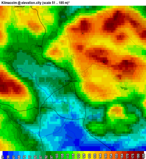
Below is the Elevation map of Kilmacolm, which displays elevation range with different colors. Scale of the first map is from 51 to 185 m (167 to 607 ft) with average elevation of 114.3 meters (=375 ft) [note 1]
These maps also provides idea of topography and contour of this city, they are displayed at different zoom levels. More info about maps, scale and edge coordinates you can find below images.
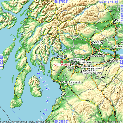
| \ | Map #1 | Map #2 | Topo.Map |
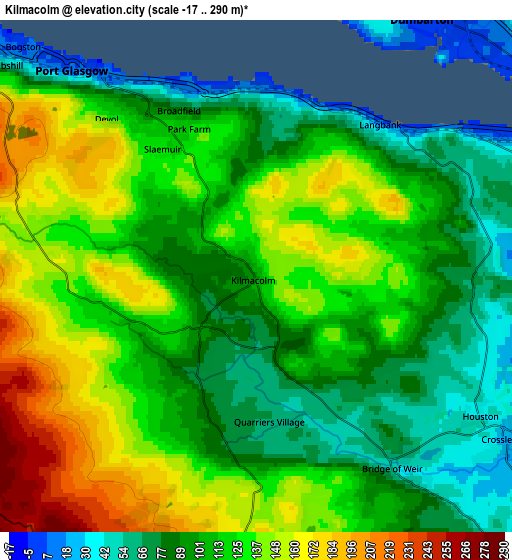
| Scale [m] | 51..185 m | -17..290 m | × |
| Scale [ft] | 167..607 ft | -56..951 ft | × |
| Average | 114.3 m = 375 ft | 114.5 m = 376 ft | × |
| Width | 5.48 km = 3.4 mi | 10.96 km = 6.8 mi | 175.4 km = 109 mi |
| Height | 5.48 km = 3.4 mi | 10.96 km = 6.8 mi | 175.3 km = 108.9 mi |
| ↑Max Latitude | 55.919333° | 55.94395° | 56.67522° |
| Latitude at center | 55.8947° | 55.8947° | 55.8947° |
| ↓Min Latitude | 55.870051° | 55.845387° | 55.09815° |
| ← Min Longitude | -4.670375° | -4.714321° | -6.03268° |
| Longitude center | -4.62643° | -4.62643° | -4.62643° |
| →Max Longitude | -4.582485° | -4.538539° | -3.22018° |
Nearby cities:
Cities around Kilmacolm sort by population:
• Vale of Leven elevation 9 m
9 km,  19°
19°
• Dumbarton 4 m
6.5 km,  32°
32°
• Johnstone 36 m
10 km,  136°
136°
• Port Glasgow 7 m
5.9 km,  318°
318°
• Bonhill 59 m
10.2 km, 22°
• Linwood 11 m
9.8 km,  121°
121°
• Houston 41 m
5.5 km, 122°
• Bridge of Weir 65 m
5.2 km,  145°
145°
• Bishopton 31 m
7.7 km,  77°
77°
• Kilbarchan 54 m
7.9 km, 145°
• Renton 12 m
9 km, 17°
• Cardross 8 m
7.6 km,  347°
347°
Multilingual:
 En español:
Kilmacolm elevación 101 m.
 En France:
Kilmacolm élévation 101 m.
 Auf Deutsch:
Kilmacolm höhe über dem Meeresspiegel ist 101 m.

Sources and notes:
- [note 1] Map square and city borders are not equal. Map elevation data is calculated only from area inside that square.
- [src 1] Elevation data from geonames database provided with same terms of usage.
- [src 2] The elevation map of Kilmacolm is generated using elevation data from NASA's 3 arcsec (90m) resolution SRTM data.
- [src 3] Base (background) map © OpenStreetMap contributors tiles are generated by Geofabrik and OpenTopoMap.
Copyright & License:
This Kilmacolm Elevation Map is licensed under CC BY-SA. You may reuse any part from this page, if you give a proper credit by linking to this URL:
 More info on terms of use page.