Bingley elevation
Bingley (England, Bradford), United Kingdom elevation is 91 meters and Bingley elevation in feet is 299 ft above sea level [src 1]. Bingley is a populated place (feature code) with elevation that is 19 meters (62 ft) bigger than average city elevation in United Kingdom.
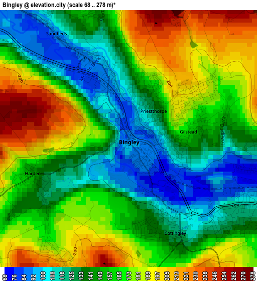
Below is the Elevation map of Bingley, which displays elevation range with different colors. Scale of the first map is from 68 to 278 m (223 to 912 ft) with average elevation of 157.1 meters (=515 ft) [note 1]
These maps also provides idea of topography and contour of this city, they are displayed at different zoom levels. More info about maps, scale and edge coordinates you can find below images.
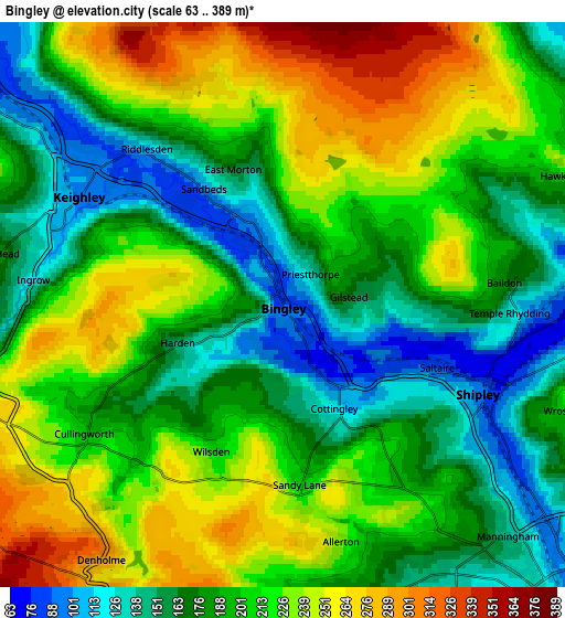
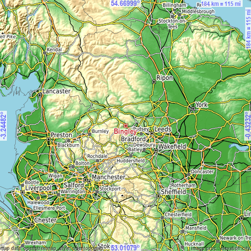
| \ | Map #1 | Map #2 | Topo.Map |
| Scale [m] | 68..278 m | 63..389 m | × |
| Scale [ft] | 223..912 ft | 207..1276 ft | × |
| Average | 157.1 m = 515 ft | 199.8 m = 656 ft | × |
| Width | 5.76 km = 3.6 mi | 11.53 km = 7.2 mi | 184.5 km = 114.6 mi |
| Height | 5.76 km = 3.6 mi | 11.53 km = 7.2 mi | 184.5 km = 114.6 mi |
| ↑Max Latitude | 53.874526° | 53.900426° | 54.66999° |
| Latitude at center | 53.84861° | 53.84861° | 53.84861° |
| ↓Min Latitude | 53.822678° | 53.796729° | 53.01079° |
| ← Min Longitude | -1.882515° | -1.926461° | -3.24482° |
| Longitude center | -1.83857° | -1.83857° | -1.83857° |
| →Max Longitude | -1.794625° | -1.750679° | -0.43232° |
Nearby cities:
Cities around Bingley sort by population:
• Bradford elevation 110 m
8.3 km,  136°
136°
• Keighley 108 m
5 km,  295°
295°
• Shipley 93 m
5 km,  109°
109°
• Baildon 155 m
3.3 km,  92°
92°
• Ilkley 102 m
8.5 km,  6°
6°
• Haworth 177 m
7.5 km,  253°
253°
• Wilsden 216 m
3.4 km,  204°
204°
• Menston 144 m
7.8 km,  53°
53°
• Steeton 244 m
8.3 km, 297°
• Denholme 289 m
6.4 km,  215°
215°
• Cullingworth 205 m
4.7 km,  235°
235°
• Oxenhope 212 m
8.5 km, 241°
Multilingual:
 En español:
Bingley elevación 91 m.
 En France:
Bingley élévation 91 m.


Sources and notes:
- [note 1] Map square and city borders are not equal. Map elevation data is calculated only from area inside that square.
- [src 1] Elevation data from geonames database provided with same terms of usage.
- [src 2] The elevation map of Bingley is generated using elevation data from NASA's 3 arcsec (90m) resolution SRTM data.
- [src 3] Base (background) map © OpenStreetMap contributors tiles are generated by Geofabrik and OpenTopoMap.
Copyright & License:
This Bingley Elevation Map is licensed under CC BY-SA. You may reuse any part from this page, if you give a proper credit by linking to this URL:
 More info on terms of use page.