Bishopstone elevation
Bishopstone (England, Wiltshire), United Kingdom elevation is 70 meters and Bishopstone elevation in feet is 230 ft above sea level [src 1]. Bishopstone is a seat of a third-order administrative division (feature code) with elevation that is 2 meters (7 ft) smaller than average city elevation in United Kingdom.
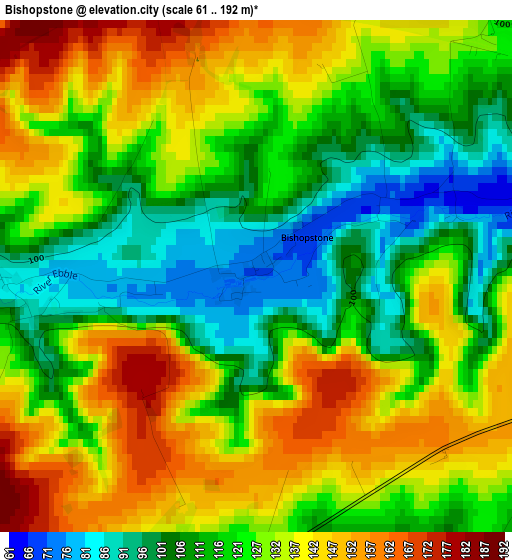
Below is the Elevation map of Bishopstone, which displays elevation range with different colors. Scale of the first map is from 61 to 192 m (200 to 630 ft) with average elevation of 124.9 meters (=410 ft) [note 1]
These maps also provides idea of topography and contour of this city, they are displayed at different zoom levels. More info about maps, scale and edge coordinates you can find below images.
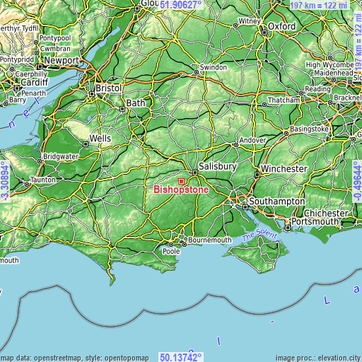
| \ | Map #1 | Topo.Map |
| Scale [m] | 61..192 m | × |
| Scale [ft] | 200..630 ft | × |
| Average | 124.9 m = 410 ft | × |
| Width | 6.15 km = 3.8 mi | 196.7 km = 122.2 mi |
| Height | 6.15 km = 3.8 mi | 196.7 km = 122.2 mi |
| ↑Max Latitude | 51.057909° | 51.90627° |
| Latitude at center | 51.03028° | 51.03028° |
| ↓Min Latitude | 51.002634° | 50.13742° |
| ← Min Longitude | -1.946635° | -3.30894° |
| Longitude center | -1.90269° | -1.90269° |
| →Max Longitude | -1.858745° | -0.49644° |
Nearby cities:
Cities around Bishopstone sort by population:
• Salisbury elevation 50 m
8.6 km,  59°
59°
• Fordingbridge 27 m
13.9 km,  145°
145°
• Wilton 55 m
6.1 km,  27°
27°
• Downton 35 m
11.3 km,  111°
111°
• Alderbury 94 m
11.9 km,  82°
82°
• Tisbury 96 m
13 km,  286°
286°
• Dinton 89 m
8.2 km,  316°
316°
• Durnford 70 m
12.9 km, 27°
• Ansty 124 m
11.3 km,  273°
273°
• Woodford 85 m
10.8 km, 26°
• Stapleford 116 m
9.6 km,  1°
1°
• Bower Chalke 208 m
5.6 km,  233°
233°
Multilingual:
 En español:
Bishopstone elevación 70 m.
 En France:
Bishopstone élévation 70 m.
 Auf Deutsch:
Bishopstone höhe über dem Meeresspiegel ist 70 m.

Sources and notes:
- [note 1] Map square and city borders are not equal. Map elevation data is calculated only from area inside that square.
- [src 1] Elevation data from geonames database provided with same terms of usage.
- [src 2] The elevation map of Bishopstone is generated using elevation data from NASA's 3 arcsec (90m) resolution SRTM data.
- [src 3] Base (background) map © OpenStreetMap contributors tiles are generated by Geofabrik and OpenTopoMap.
Copyright & License:
This Bishopstone Elevation Map is licensed under CC BY-SA. You may reuse any part from this page, if you give a proper credit by linking to this URL:
 More info on terms of use page.