Blandford Forum elevation
Blandford Forum (England, Dorset), United Kingdom elevation is 52 meters and Blandford Forum elevation in feet is 171 ft above sea level [src 1]. Blandford Forum is a populated place (feature code) with elevation that is 20 meters (66 ft) smaller than average city elevation in United Kingdom.
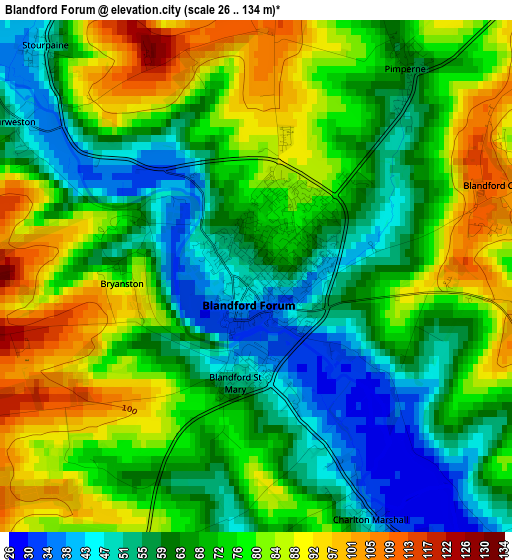
Below is the Elevation map of Blandford Forum, which displays elevation range with different colors. Scale of the first map is from 26 to 134 m (85 to 440 ft) with average elevation of 70.7 meters (=232 ft) [note 1]
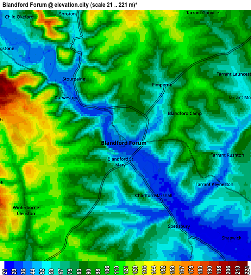
These maps also provides idea of topography and contour of this city, they are displayed at different zoom levels. More info about maps, scale and edge coordinates you can find below images.
| \ | Map #1 | Map #2 | Topo.Map |
| Scale [m] | 26..134 m | 21..221 m | × |
| Scale [ft] | 85..440 ft | 69..725 ft | × |
| Average | 70.7 m = 232 ft | 84.4 m = 277 ft | × |
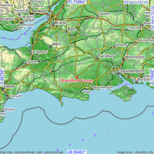
| Width | 6.17 km = 3.8 mi | 12.34 km = 7.7 mi | 197.4 km = 122.7 mi |
| Height | 6.17 km = 3.8 mi | 12.34 km = 7.7 mi | 197.4 km = 122.7 mi |
| ↑Max Latitude | 50.88846° | 50.916174° | 51.73994° |
| Latitude at center | 50.86073° | 50.86073° | 50.86073° |
| ↓Min Latitude | 50.832983° | 50.80522° | 49.96463° |
| ← Min Longitude | -2.205685° | -2.249631° | -3.56799° |
| Longitude center | -2.16174° | -2.16174° | -2.16174° |
| →Max Longitude | -2.117795° | -2.073849° | -0.75549° |
Nearby cities:
Cities around Blandford Forum sort by population:
• Wimborne Minster elevation 47 m
15.2 km,  124°
124°
• Manston 51 m
12.4 km,  323°
323°
• Sturminster Newton 62 m
12.5 km,  306°
306°
• Lytchett Matravers 86 m
12.8 km,  152°
152°
• Sturminster Marshall 23 m
9.1 km,  138°
138°
• Marnhull 69 m
16.2 km, 318°
• Bere Regis 44 m
12.5 km,  197°
197°
• Shillingstone 51 m
7 km,  303°
303°
• Child Okeford 74 m
7.9 km, 318°
• Pimperne 60 m
3.1 km,  35°
35°
• Milborne St Andrew 75 m
12.4 km,  222°
222°
• Charlton Marshall 34 m
3.1 km, 153°
Multilingual:
 En español:
Blandford Forum elevación 52 m.
 En France:
Blandford Forum élévation 52 m.
 Auf Deutsch:
Blandford Forum höhe über dem Meeresspiegel ist 52 m.

Sources and notes:
- [note 1] Map square and city borders are not equal. Map elevation data is calculated only from area inside that square.
- [src 1] Elevation data from geonames database provided with same terms of usage.
- [src 2] The elevation map of Blandford Forum is generated using elevation data from NASA's 3 arcsec (90m) resolution SRTM data.
- [src 3] Base (background) map © OpenStreetMap contributors tiles are generated by Geofabrik and OpenTopoMap.
Copyright & License:
This Blandford Forum Elevation Map is licensed under CC BY-SA. You may reuse any part from this page, if you give a proper credit by linking to this URL:
 More info on terms of use page.