Blyth elevation
Blyth (England, Northumberland), United Kingdom elevation is 5 meters and Blyth elevation in feet is 16 ft above sea level [src 1]. Blyth is a seat of a third-order administrative division (feature code) with elevation that is 67 meters (220 ft) smaller than average city elevation in United Kingdom.
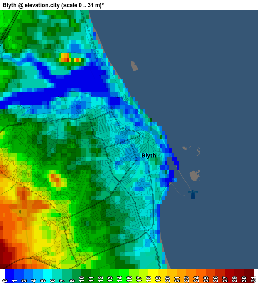
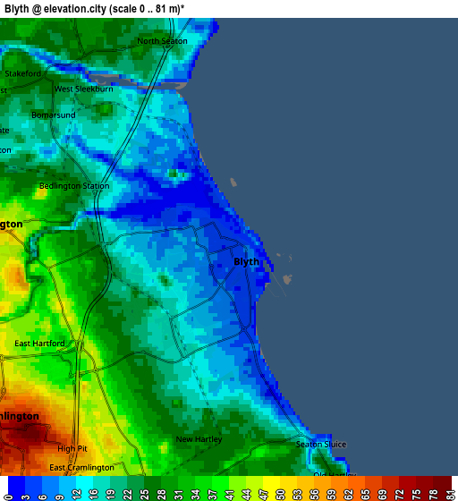
Below is the Elevation map of Blyth, which displays elevation range with different colors. Scale of the first map is from 0 to 31 m (0 to 102 ft) with average elevation of 10 meters (=33 ft) [note 1]
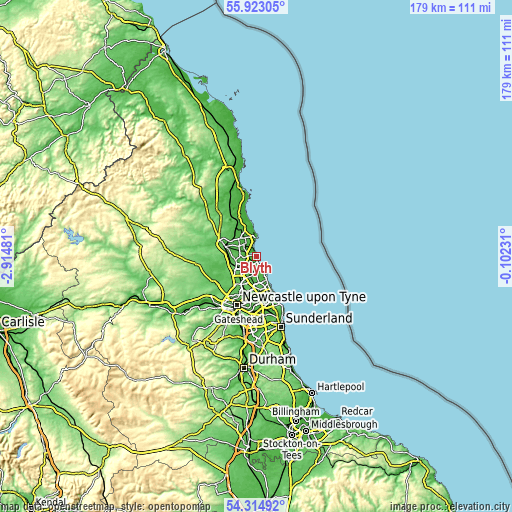
These maps also provides idea of topography and contour of this city, they are displayed at different zoom levels. More info about maps, scale and edge coordinates you can find below images.
| \ | Map #1 | Map #2 | Topo.Map |
| Scale [m] | 0..31 m | 0..81 m | × |
| Scale [ft] | 0..102 ft | 0..266 ft | × |
| Average | 10 m = 33 ft | 24.9 m = 82 ft | × |
| Width | 5.59 km = 3.5 mi | 11.18 km = 6.9 mi | 178.8 km = 111.1 mi |
| Height | 5.59 km = 3.5 mi | 11.18 km = 6.9 mi | 178.8 km = 111.1 mi |
| ↑Max Latitude | 55.152198° | 55.177301° | 55.92305° |
| Latitude at center | 55.12708° | 55.12708° | 55.12708° |
| ↓Min Latitude | 55.101946° | 55.076796° | 54.31492° |
| ← Min Longitude | -1.552505° | -1.596451° | -2.91481° |
| Longitude center | -1.50856° | -1.50856° | -1.50856° |
| →Max Longitude | -1.464615° | -1.420669° | -0.10231° |
Nearby cities:
Cities around Blyth sort by population:
• Cramlington elevation 78 m
6.7 km,  227°
227°
• Ashington 32 m
6.6 km,  327°
327°
• Bedlington 49 m
5.4 km,  274°
274°
• Stakeford 24 m
5.7 km,  311°
311°
• Seaton Delaval 38 m
6.2 km,  190°
190°
• Newbiggin-by-the-Sea 11 m
6.5 km,  356°
356°
• Shiremoor 62 m
10.2 km,  180°
180°
• Choppington 28 m
6.5 km,  292°
292°
• Seghill 41 m
7.7 km,  200°
200°
• Lynemouth 20 m
9.8 km,  347°
347°
• Backworth 59 m
9.5 km, 187°
• Cresswell 18 m
10.3 km, 345°
Multilingual:
 En español:
Blyth elevación 5 m.
 En France:
Blyth élévation 5 m.


Sources and notes:
- [note 1] Map square and city borders are not equal. Map elevation data is calculated only from area inside that square.
- [src 1] Elevation data from geonames database provided with same terms of usage.
- [src 2] The elevation map of Blyth is generated using elevation data from NASA's 3 arcsec (90m) resolution SRTM data.
- [src 3] Base (background) map © OpenStreetMap contributors tiles are generated by Geofabrik and OpenTopoMap.
Copyright & License:
This Blyth Elevation Map is licensed under CC BY-SA. You may reuse any part from this page, if you give a proper credit by linking to this URL:
 More info on terms of use page.