Cramlington elevation
Cramlington (England, Northumberland), United Kingdom elevation is 78 meters and Cramlington elevation in feet is 256 ft above sea level [src 1]. Cramlington is a seat of a third-order administrative division (feature code) with elevation that is 6 meters (20 ft) bigger than average city elevation in United Kingdom.
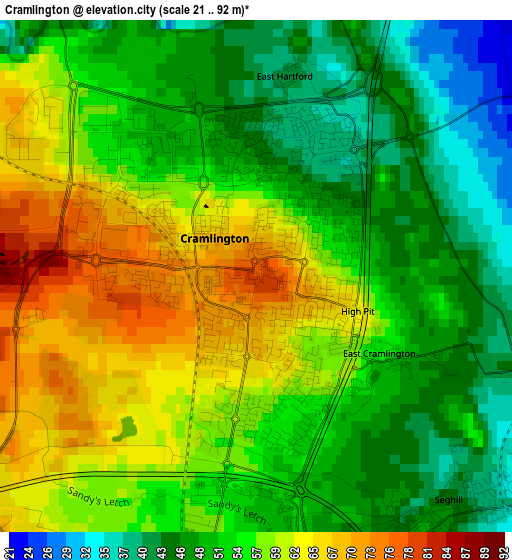
Below is the Elevation map of Cramlington, which displays elevation range with different colors. Scale of the first map is from 21 to 92 m (69 to 302 ft) with average elevation of 54.2 meters (=178 ft) [note 1]
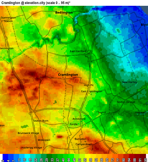
These maps also provides idea of topography and contour of this city, they are displayed at different zoom levels. More info about maps, scale and edge coordinates you can find below images.
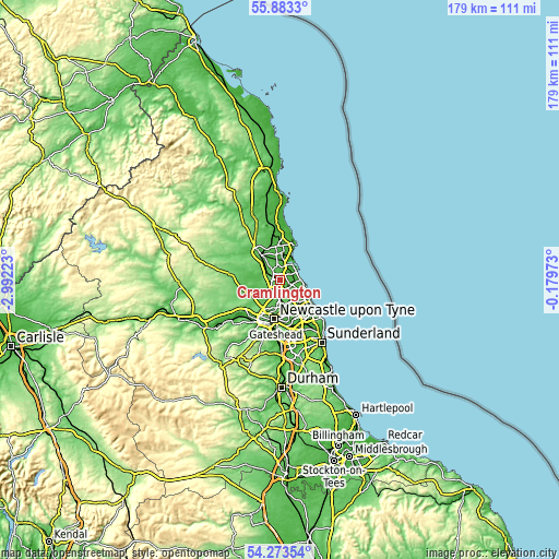
| \ | Map #1 | Map #2 | Topo.Map |
| Scale [m] | 21..92 m | 0..95 m | × |
| Scale [ft] | 69..302 ft | 0..312 ft | × |
| Average | 54.2 m = 178 ft | 48.4 m = 159 ft | × |
| Width | 5.59 km = 3.5 mi | 11.19 km = 7 mi | 179 km = 111.2 mi |
| Height | 5.59 km = 3.5 mi | 11.19 km = 7 mi | 179 km = 111.2 mi |
| ↑Max Latitude | 55.111664° | 55.136792° | 55.8833° |
| Latitude at center | 55.08652° | 55.08652° | 55.08652° |
| ↓Min Latitude | 55.06136° | 55.036185° | 54.27354° |
| ← Min Longitude | -1.629925° | -1.673871° | -2.99223° |
| Longitude center | -1.58598° | -1.58598° | -1.58598° |
| →Max Longitude | -1.542035° | -1.498089° | -0.17973° |
Nearby cities:
Cities around Cramlington sort by population:
• Blyth elevation 5 m
6.7 km,  47°
47°
• Bedlington 49 m
4.9 km,  354°
354°
• Stakeford 24 m
8.3 km,  4°
4°
• Seaton Delaval 38 m
4.1 km,  113°
113°
• Wideopen 69 m
5.2 km,  206°
206°
• Shiremoor 62 m
7.5 km,  139°
139°
• Choppington 28 m
7.1 km, 351°
• Seghill 41 m
3.5 km, 139°
• Dinnington 68 m
6.7 km,  237°
237°
• Backworth 59 m
6.2 km, 143°
• Hazlerigg 70 m
6.1 km, 213°
• Stannington 63 m
5.8 km,  295°
295°
Multilingual:
 En español:
Cramlington elevación 78 m.
 En France:
Cramlington élévation 78 m.
 Auf Deutsch:
Cramlington höhe über dem Meeresspiegel ist 78 m.

Sources and notes:
- [note 1] Map square and city borders are not equal. Map elevation data is calculated only from area inside that square.
- [src 1] Elevation data from geonames database provided with same terms of usage.
- [src 2] The elevation map of Cramlington is generated using elevation data from NASA's 3 arcsec (90m) resolution SRTM data.
- [src 3] Base (background) map © OpenStreetMap contributors tiles are generated by Geofabrik and OpenTopoMap.
Copyright & License:
This Cramlington Elevation Map is licensed under CC BY-SA. You may reuse any part from this page, if you give a proper credit by linking to this URL:
 More info on terms of use page.