Brampton elevation
Brampton (England, Cumbria), United Kingdom elevation is 72 meters and Brampton elevation in feet is 236 ft above sea level [src 1]. Brampton is a populated place (feature code) with elevation that is 0 meters (0 ft) bigger than average city elevation in United Kingdom.
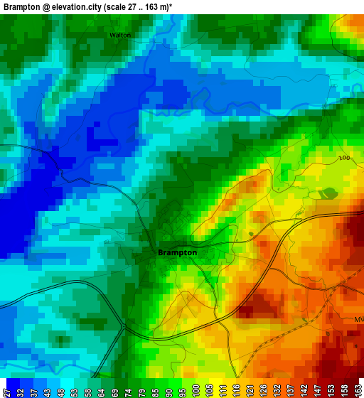
Below is the Elevation map of Brampton, which displays elevation range with different colors. Scale of the first map is from 27 to 163 m (89 to 535 ft) with average elevation of 75.4 meters (=247 ft) [note 1]
These maps also provides idea of topography and contour of this city, they are displayed at different zoom levels. More info about maps, scale and edge coordinates you can find below images.
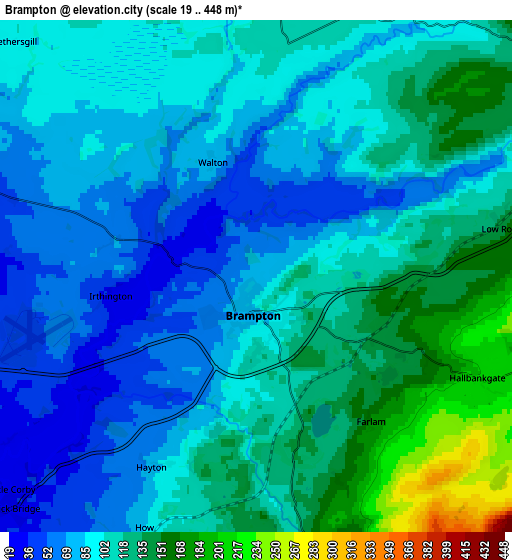
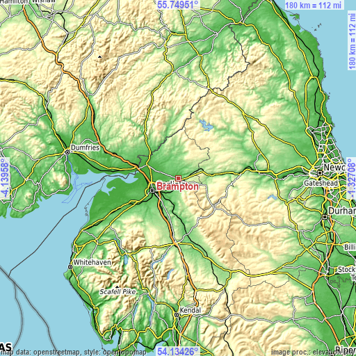
| \ | Map #1 | Map #2 | Topo.Map |
| Scale [m] | 27..163 m | 19..448 m | × |
| Scale [ft] | 89..535 ft | 62..1470 ft | × |
| Average | 75.4 m = 247 ft | 102.9 m = 338 ft | × |
| Width | 5.61 km = 3.5 mi | 11.22 km = 7 mi | 179.6 km = 111.6 mi |
| Height | 5.61 km = 3.5 mi | 11.22 km = 7 mi | 179.6 km = 111.6 mi |
| ↑Max Latitude | 54.975229° | 55.000443° | 55.74951° |
| Latitude at center | 54.95° | 54.95° | 54.95° |
| ↓Min Latitude | 54.924755° | 54.899493° | 54.13426° |
| ← Min Longitude | -2.777275° | -2.821221° | -4.13958° |
| Longitude center | -2.73333° | -2.73333° | -2.73333° |
| →Max Longitude | -2.689385° | -2.645439° | -1.32708° |
Nearby cities:
Cities around Brampton sort by population:
• Carlisle elevation 29 m
14.4 km,  245°
245°
• Denton Holme 18 m
15.1 km,  241°
241°
• Haltwhistle 124 m
17.8 km,  82°
82°
• Gretna 17 m
21.8 km,  282°
282°
• Langholm 80 m
28 km,  322°
322°
• Longtown 19 m
16.3 km,  293°
293°
• Wetheral 58 m
9.7 km,  221°
221°
• Scotby 30 m
11.2 km,  233°
233°
• Dalston 45 m
20.1 km, 233°
• Alston 298 m
24.5 km,  129°
129°
• Bardon Mill 100 m
25.1 km, 83°
• Greenhead 180 m
14 km, 82°
Multilingual:
 En español:
Brampton elevación 72 m.
 En France:
Brampton élévation 72 m.


Sources and notes:
- [note 1] Map square and city borders are not equal. Map elevation data is calculated only from area inside that square.
- [src 1] Elevation data from geonames database provided with same terms of usage.
- [src 2] The elevation map of Brampton is generated using elevation data from NASA's 3 arcsec (90m) resolution SRTM data.
- [src 3] Base (background) map © OpenStreetMap contributors tiles are generated by Geofabrik and OpenTopoMap.
Copyright & License:
This Brampton Elevation Map is licensed under CC BY-SA. You may reuse any part from this page, if you give a proper credit by linking to this URL:
 More info on terms of use page.