Burbage elevation
Burbage (England, Wiltshire), United Kingdom elevation is 166 meters and Burbage elevation in feet is 545 ft above sea level [src 1]. Burbage is a seat of a third-order administrative division (feature code) with elevation that is 94 meters (308 ft) bigger than average city elevation in United Kingdom.
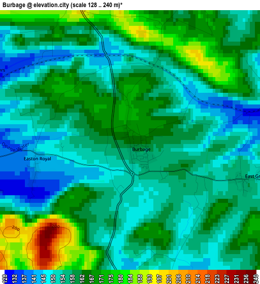
Below is the Elevation map of Burbage, which displays elevation range with different colors. Scale of the first map is from 128 to 240 m (420 to 787 ft) with average elevation of 159.8 meters (=524 ft) [note 1]
These maps also provides idea of topography and contour of this city, they are displayed at different zoom levels. More info about maps, scale and edge coordinates you can find below images.
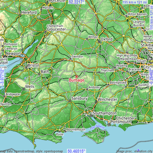
| \ | Map #1 | Topo.Map |
| Scale [m] | 128..240 m | × |
| Scale [ft] | 420..787 ft | × |
| Average | 159.8 m = 524 ft | × |
| Width | 6.1 km = 3.8 mi | 195.3 km = 121.4 mi |
| Height | 6.1 km = 3.8 mi | 195.3 km = 121.4 mi |
| ↑Max Latitude | 51.379277° | 52.2217° |
| Latitude at center | 51.35184° | 51.35184° |
| ↓Min Latitude | 51.324386° | 50.46515° |
| ← Min Longitude | -1.714815° | -3.07712° |
| Longitude center | -1.67087° | -1.67087° |
| →Max Longitude | -1.626925° | -0.26462° |
Nearby cities:
Cities around Burbage sort by population:
• Marlborough elevation 130 m
8.6 km,  331°
331°
• Ludgershall 128 m
11.2 km,  162°
162°
• Pewsey 115 m
6.7 km,  257°
257°
• Ramsbury 121 m
11.3 km,  24°
24°
• Great Bedwyn 125 m
5.7 km,  57°
57°
• Shalbourne 136 m
8.5 km,  81°
81°
• Collingbourne Kingston 144 m
5.7 km,  171°
171°
• Mildenhall 133 m
8.4 km,  346°
346°
• Woodborough 120 m
11.8 km, 262°
• Rushall 145 m
12.7 km,  233°
233°
• Fyfield 137 m
10.6 km,  312°
312°
• Huish 152 m
8.7 km,  284°
284°
Multilingual:
 En español:
Burbage elevación 166 m.
 En France:
Burbage élévation 166 m.


Sources and notes:
- [note 1] Map square and city borders are not equal. Map elevation data is calculated only from area inside that square.
- [src 1] Elevation data from geonames database provided with same terms of usage.
- [src 2] The elevation map of Burbage is generated using elevation data from NASA's 3 arcsec (90m) resolution SRTM data.
- [src 3] Base (background) map © OpenStreetMap contributors tiles are generated by Geofabrik and OpenTopoMap.
Copyright & License:
This Burbage Elevation Map is licensed under CC BY-SA. You may reuse any part from this page, if you give a proper credit by linking to this URL:
 More info on terms of use page.