Catrine elevation
Catrine (Scotland, East Ayrshire), United Kingdom elevation is 96 meters and Catrine elevation in feet is 315 ft above sea level [src 1]. Catrine is a populated place (feature code) with elevation that is 24 meters (79 ft) bigger than average city elevation in United Kingdom.
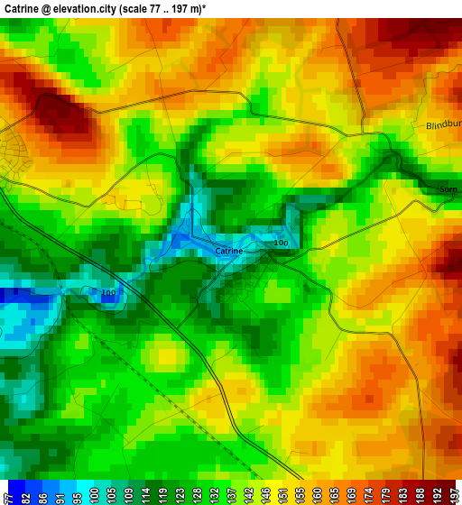
Below is the Elevation map of Catrine, which displays elevation range with different colors. Scale of the first map is from 77 to 197 m (253 to 646 ft) with average elevation of 142.6 meters (=468 ft) [note 1]
These maps also provides idea of topography and contour of this city, they are displayed at different zoom levels. More info about maps, scale and edge coordinates you can find below images.
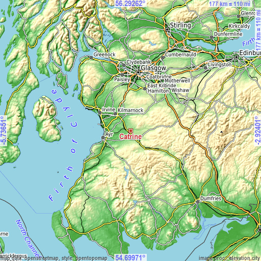
| \ | Map #1 | Topo.Map |
| Scale [m] | 77..197 m | × |
| Scale [ft] | 253..646 ft | × |
| Average | 142.6 m = 468 ft | × |
| Width | 5.53 km = 3.4 mi | 177.1 km = 110 mi |
| Height | 5.53 km = 3.4 mi | 177.1 km = 110 mi |
| ↑Max Latitude | 55.5291° | 56.29262° |
| Latitude at center | 55.50422° | 55.50422° |
| ↓Min Latitude | 55.479324° | 54.69971° |
| ← Min Longitude | -4.374205° | -5.73651° |
| Longitude center | -4.33026° | -4.33026° |
| →Max Longitude | -4.286315° | -2.92401° |
Nearby cities:
Cities around Catrine sort by population:
• Cumnock elevation 115 m
6.8 km,  143°
143°
• Galston 52 m
11.2 km,  343°
343°
• Mauchline 145 m
3.4 km,  293°
293°
• Darvel 104 m
12.1 km,  14°
14°
• Auchinleck 157 m
4.3 km,  147°
147°
• Drongan 106 m
11 km,  225°
225°
• Newmilns 73 m
11.5 km,  1°
1°
• Coylton 73 m
13.6 km,  241°
241°
• Mossblown 50 m
12.6 km,  262°
262°
• Tarbolton 98 m
9.9 km,  275°
275°
• Logan 164 m
8.1 km,  132°
132°
• Ochiltree 132 m
5.5 km,  205°
205°
Multilingual:
 En español:
Catrine elevación 96 m.
 En France:
Catrine élévation 96 m.


Sources and notes:
- [note 1] Map square and city borders are not equal. Map elevation data is calculated only from area inside that square.
- [src 1] Elevation data from geonames database provided with same terms of usage.
- [src 2] The elevation map of Catrine is generated using elevation data from NASA's 3 arcsec (90m) resolution SRTM data.
- [src 3] Base (background) map © OpenStreetMap contributors tiles are generated by Geofabrik and OpenTopoMap.
Copyright & License:
This Catrine Elevation Map is licensed under CC BY-SA. You may reuse any part from this page, if you give a proper credit by linking to this URL:
 More info on terms of use page.