Chilton Foliat elevation
Chilton Foliat (England, Wiltshire), United Kingdom elevation is 107 meters and Chilton Foliat elevation in feet is 351 ft above sea level [src 1]. Chilton Foliat is a seat of a third-order administrative division (feature code) with elevation that is 35 meters (115 ft) bigger than average city elevation in United Kingdom.
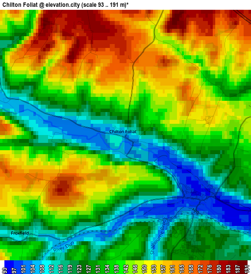
Below is the Elevation map of Chilton Foliat, which displays elevation range with different colors. Scale of the first map is from 93 to 191 m (305 to 627 ft) with average elevation of 138.9 meters (=456 ft) [note 1]
These maps also provides idea of topography and contour of this city, they are displayed at different zoom levels. More info about maps, scale and edge coordinates you can find below images.
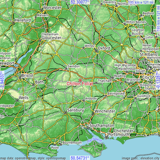
| \ | Map #1 | Topo.Map |
| Scale [m] | 93..191 m | × |
| Scale [ft] | 305..627 ft | × |
| Average | 138.9 m = 456 ft | × |
| Width | 6.09 km = 3.8 mi | 195 km = 121.2 mi |
| Height | 6.09 km = 3.8 mi | 194.9 km = 121.1 mi |
| ↑Max Latitude | 51.459839° | 52.30077° |
| Latitude at center | 51.43245° | 51.43245° |
| ↓Min Latitude | 51.405045° | 50.54731° |
| ← Min Longitude | -1.583065° | -2.94537° |
| Longitude center | -1.53912° | -1.53912° |
| →Max Longitude | -1.495175° | -0.13287° |
Nearby cities:
Cities around Chilton Foliat sort by population:
• Hungerford elevation 103 m
2.5 km,  139°
139°
• Lambourn 130 m
8.4 km,  3°
3°
• Kintbury 101 m
7.3 km,  120°
120°
• Wickham 149 m
7.5 km,  80°
80°
• Burbage 166 m
12.8 km,  225°
225°
• Aldbourne 134 m
7.7 km,  314°
314°
• Ramsbury 121 m
4.6 km,  285°
285°
• Great Bedwyn 125 m
7.3 km,  216°
216°
• Shalbourne 136 m
7.7 km,  185°
185°
• Mildenhall 133 m
11.2 km,  266°
266°
• Chaddleworth 154 m
11.5 km,  54°
54°
• Welford 106 m
9.3 km,  72°
72°
Multilingual:
 En español:
Chilton Foliat elevación 107 m.
 En France:
Chilton Foliat élévation 107 m.
 Auf Deutsch:
Chilton Foliat höhe über dem Meeresspiegel ist 107 m.

Sources and notes:
- [note 1] Map square and city borders are not equal. Map elevation data is calculated only from area inside that square.
- [src 1] Elevation data from geonames database provided with same terms of usage.
- [src 2] The elevation map of Chilton Foliat is generated using elevation data from NASA's 3 arcsec (90m) resolution SRTM data.
- [src 3] Base (background) map © OpenStreetMap contributors tiles are generated by Geofabrik and OpenTopoMap.
Copyright & License:
This Chilton Foliat Elevation Map is licensed under CC BY-SA. You may reuse any part from this page, if you give a proper credit by linking to this URL:
 More info on terms of use page.