Coldstream elevation
Coldstream (Scotland, The Scottish Borders), United Kingdom elevation is 27 meters and Coldstream elevation in feet is 89 ft above sea level [src 1]. Coldstream is a populated place (feature code) with elevation that is 45 meters (148 ft) smaller than average city elevation in United Kingdom.
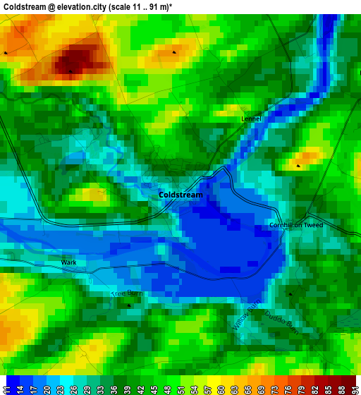
Below is the Elevation map of Coldstream, which displays elevation range with different colors. Scale of the first map is from 11 to 91 m (36 to 299 ft) with average elevation of 38.6 meters (=127 ft) [note 1]
These maps also provides idea of topography and contour of this city, they are displayed at different zoom levels. More info about maps, scale and edge coordinates you can find below images.
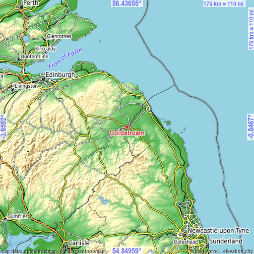
| \ | Map #1 | Topo.Map |
| Scale [m] | 11..91 m | × |
| Scale [ft] | 36..299 ft | × |
| Average | 38.6 m = 127 ft | × |
| Width | 5.51 km = 3.4 mi | 176.5 km = 109.7 mi |
| Height | 5.51 km = 3.4 mi | 176.4 km = 109.6 mi |
| ↑Max Latitude | 55.675897° | 56.43655° |
| Latitude at center | 55.65111° | 55.65111° |
| ↓Min Latitude | 55.626307° | 54.84959° |
| ← Min Longitude | -2.296895° | -3.6592° |
| Longitude center | -2.25295° | -2.25295° |
| →Max Longitude | -2.209005° | -0.8467° |
Nearby cities:
Cities around Coldstream sort by population:
• Berwick-Upon-Tweed elevation 14 m
19.7 km,  49°
49°
• Kelso 40 m
12.8 km,  242°
242°
• Duns 134 m
15.2 km,  337°
337°
• Wooler 56 m
19 km,  127°
127°
• Chirnside 127 m
17 km,  9°
9°
• Allanton 53 m
14.9 km, 8°
• Maxwellheugh 61 m
12.8 km, 239°
• Lowick 100 m
17.2 km,  90°
90°
• Doddington 53 m
17.2 km,  115°
115°
• Ancroft 30 m
16.8 km,  71°
71°
• Kirknewton 322 m
13.5 km,  146°
146°
• Ford 88 m
10.8 km,  100°
100°
Multilingual:
 En español:
Coldstream elevación 27 m.
 En France:
Coldstream élévation 27 m.
 Auf Deutsch:
Coldstream höhe über dem Meeresspiegel ist 27 m.

Sources and notes:
- [note 1] Map square and city borders are not equal. Map elevation data is calculated only from area inside that square.
- [src 1] Elevation data from geonames database provided with same terms of usage.
- [src 2] The elevation map of Coldstream is generated using elevation data from NASA's 3 arcsec (90m) resolution SRTM data.
- [src 3] Base (background) map © OpenStreetMap contributors tiles are generated by Geofabrik and OpenTopoMap.
Copyright & License:
This Coldstream Elevation Map is licensed under CC BY-SA. You may reuse any part from this page, if you give a proper credit by linking to this URL:
 More info on terms of use page.