Kelso elevation
Kelso (Scotland, The Scottish Borders), United Kingdom elevation is 40 meters and Kelso elevation in feet is 131 ft above sea level [src 1]. Kelso is a populated place (feature code) with elevation that is 32 meters (105 ft) smaller than average city elevation in United Kingdom.
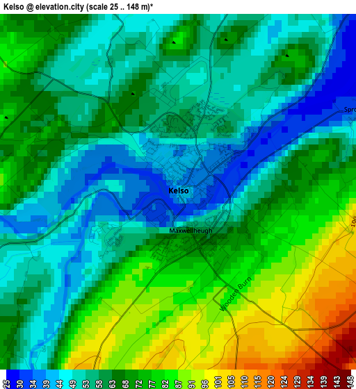
Below is the Elevation map of Kelso, which displays elevation range with different colors. Scale of the first map is from 25 to 148 m (82 to 486 ft) with average elevation of 65.2 meters (=214 ft) [note 1]
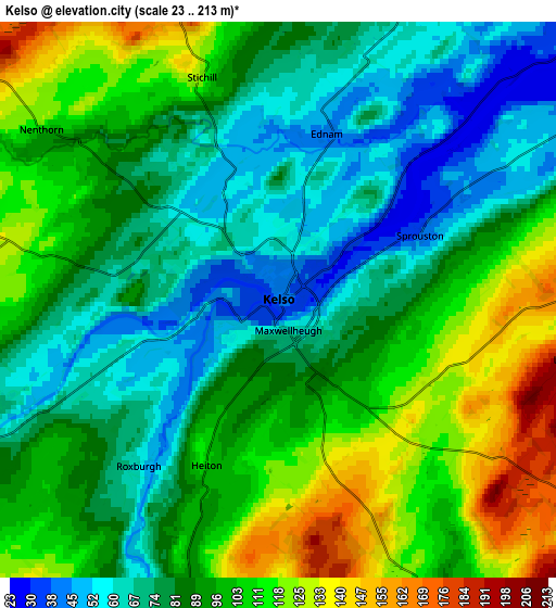
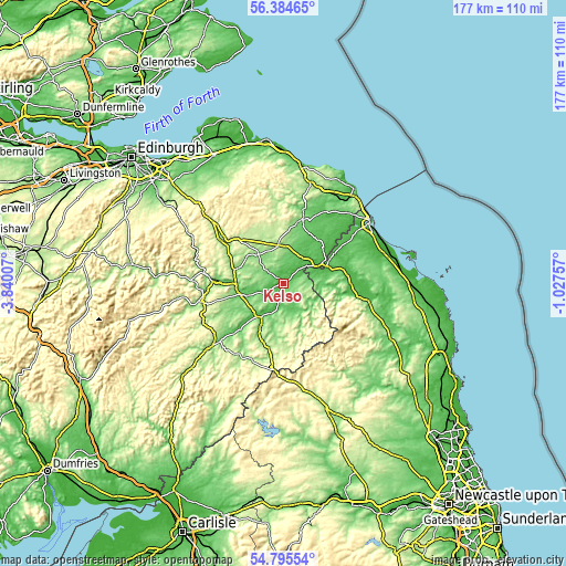
These maps also provides idea of topography and contour of this city, they are displayed at different zoom levels. More info about maps, scale and edge coordinates you can find below images.
| \ | Map #1 | Map #2 | Topo.Map |
| Scale [m] | 25..148 m | 23..213 m | × |
| Scale [ft] | 82..486 ft | 75..699 ft | × |
| Average | 65.2 m = 214 ft | 90.7 m = 298 ft | × |
| Width | 5.52 km = 3.4 mi | 11.04 km = 6.9 mi | 176.7 km = 109.8 mi |
| Height | 5.52 km = 3.4 mi | 11.04 km = 6.9 mi | 176.7 km = 109.8 mi |
| ↑Max Latitude | 55.622961° | 55.647766° | 56.38465° |
| Latitude at center | 55.59814° | 55.59814° | 55.59814° |
| ↓Min Latitude | 55.573303° | 55.548451° | 54.79554° |
| ← Min Longitude | -2.477765° | -2.521711° | -3.84007° |
| Longitude center | -2.43382° | -2.43382° | -2.43382° |
| →Max Longitude | -2.389875° | -2.345929° | -1.02757° |
Nearby cities:
Cities around Kelso sort by population:
• Galashiels elevation 119 m
23.5 km,  274°
274°
• Jedburgh 77 m
15.1 km,  209°
209°
• Duns 134 m
20.6 km,  15°
15°
• Melrose 97 m
18.5 km, 270°
• Tweedbank 100 m
20.9 km, 271°
• Coldstream 27 m
12.8 km,  62°
62°
• Earlston 108 m
15.8 km,  286°
286°
• Saint Boswells 96 m
13.5 km,  258°
258°
• Newtown St Boswells 104 m
14.9 km, 261°
• Maxwellheugh 61 m
0.7 km,  152°
152°
• Ford 88 m
22.4 km,  79°
79°
• Kirknewton 322 m
19.6 km,  105°
105°
Multilingual:
 En español:
Kelso elevación 40 m.
 En France:
Kelso élévation 40 m.


Sources and notes:
- [note 1] Map square and city borders are not equal. Map elevation data is calculated only from area inside that square.
- [src 1] Elevation data from geonames database provided with same terms of usage.
- [src 2] The elevation map of Kelso is generated using elevation data from NASA's 3 arcsec (90m) resolution SRTM data.
- [src 3] Base (background) map © OpenStreetMap contributors tiles are generated by Geofabrik and OpenTopoMap.
Copyright & License:
This Kelso Elevation Map is licensed under CC BY-SA. You may reuse any part from this page, if you give a proper credit by linking to this URL:
 More info on terms of use page.