Denton elevation
Denton (England, Borough of Tameside), United Kingdom elevation is 101 meters and Denton elevation in feet is 331 ft above sea level [src 1]. Denton is a populated place (feature code) with elevation that is 29 meters (95 ft) bigger than average city elevation in United Kingdom.
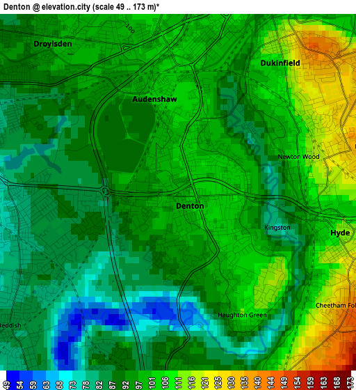
Below is the Elevation map of Denton, which displays elevation range with different colors. Scale of the first map is from 49 to 173 m (161 to 568 ft) with average elevation of 95.8 meters (=314 ft) [note 1]
These maps also provides idea of topography and contour of this city, they are displayed at different zoom levels. More info about maps, scale and edge coordinates you can find below images.
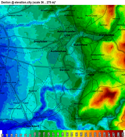
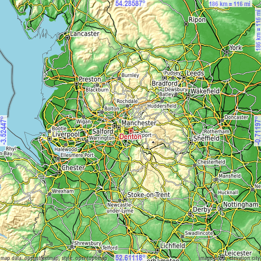
| \ | Map #1 | Map #2 | Topo.Map |
| Scale [m] | 49..173 m | 36..275 m | × |
| Scale [ft] | 161..568 ft | 118..902 ft | × |
| Average | 95.8 m = 314 ft | 106.3 m = 349 ft | × |
| Width | 5.82 km = 3.6 mi | 11.64 km = 7.2 mi | 186.2 km = 115.7 mi |
| Height | 5.82 km = 3.6 mi | 11.64 km = 7.2 mi | 186.2 km = 115.7 mi |
| ↑Max Latitude | 53.482938° | 53.50908° | 54.28587° |
| Latitude at center | 53.45678° | 53.45678° | 53.45678° |
| ↓Min Latitude | 53.430606° | 53.404415° | 52.61118° |
| ← Min Longitude | -2.162165° | -2.206111° | -3.52447° |
| Longitude center | -2.11822° | -2.11822° | -2.11822° |
| →Max Longitude | -2.074275° | -2.030329° | -0.71197° |
Nearby cities:
Cities around Denton sort by population:
• Stockport elevation 59 m
5.8 km,  206°
206°
• Ashton-under-Lyne 108 m
3.8 km,  19°
19°
• Hyde 112 m
2.6 km,  103°
103°
• Droylsden 100 m
3.2 km,  325°
325°
• Stalybridge 114 m
5 km,  52°
52°
• Failsworth 97 m
6.2 km, 329°
• Dukinfield 128 m
2.8 km,  44°
44°
• Longsight 54 m
5.5 km,  271°
271°
• Bredbury 91 m
4.5 km,  178°
178°
• Burnage 51 m
6 km,  243°
243°
• Haughton Green 113 m
2.2 km,  142°
142°
• Heaton Chapel 67 m
4.8 km,  231°
231°
Multilingual:
 En español:
Denton elevación 101 m.
 En France:
Denton élévation 101 m.


Sources and notes:
- [note 1] Map square and city borders are not equal. Map elevation data is calculated only from area inside that square.
- [src 1] Elevation data from geonames database provided with same terms of usage.
- [src 2] The elevation map of Denton is generated using elevation data from NASA's 3 arcsec (90m) resolution SRTM data.
- [src 3] Base (background) map © OpenStreetMap contributors tiles are generated by Geofabrik and OpenTopoMap.
Copyright & License:
This Denton Elevation Map is licensed under CC BY-SA. You may reuse any part from this page, if you give a proper credit by linking to this URL:
 More info on terms of use page.