Gateshead elevation
Gateshead (England), United Kingdom elevation is 53 meters and Gateshead elevation in feet is 174 ft above sea level [src 1]. Gateshead is a seat of a second-order administrative division (feature code) with elevation that is 19 meters (62 ft) smaller than average city elevation in United Kingdom.
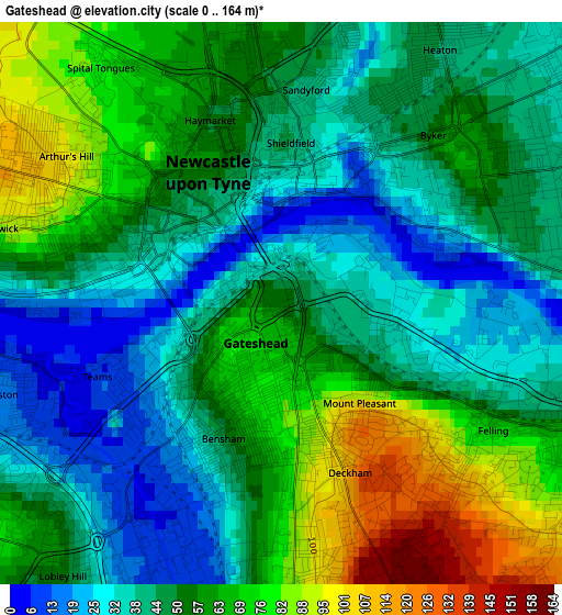
Below is the Elevation map of Gateshead, which displays elevation range with different colors. Scale of the first map is from 0 to 164 m (0 to 538 ft) with average elevation of 52.8 meters (=173 ft) [note 1]
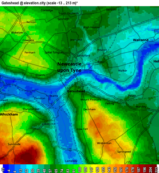
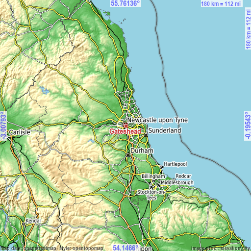
These maps also provides idea of topography and contour of this city, they are displayed at different zoom levels. More info about maps, scale and edge coordinates you can find below images.
| \ | Map #1 | Map #2 | Topo.Map |
| Scale [m] | 0..164 m | -13..213 m | × |
| Scale [ft] | 0..538 ft | -43..699 ft | × |
| Average | 52.8 m = 173 ft | 67.3 m = 221 ft | × |
| Width | 5.61 km = 3.5 mi | 11.22 km = 7 mi | 179.5 km = 111.5 mi |
| Height | 5.61 km = 3.5 mi | 11.22 km = 7 mi | 179.5 km = 111.5 mi |
| ↑Max Latitude | 54.987312° | 55.012518° | 55.76136° |
| Latitude at center | 54.96209° | 54.96209° | 54.96209° |
| ↓Min Latitude | 54.936852° | 54.911599° | 54.1466° |
| ← Min Longitude | -1.645625° | -1.689571° | -3.00793° |
| Longitude center | -1.60168° | -1.60168° | -1.60168° |
| →Max Longitude | -1.557735° | -1.513789° | -0.19543° |
Nearby cities:
Cities around Gateshead sort by population:
• Newcastle upon Tyne elevation 54 m
1.5 km,  327°
327°
• Washington 59 m
8.8 km,  141°
141°
• Wallsend 30 m
5.4 km,  53°
53°
• Felling 42 m
2.2 km,  117°
117°
• Jarrow 15 m
7.8 km,  74°
74°
• Gosforth 67 m
4.3 km,  347°
347°
• Hebburn 38 m
5.6 km,  77°
77°
• Whickham 119 m
5.1 km,  248°
248°
• Blaydon-on-Tyne 10 m
7.2 km,  272°
272°
• Benwell 93 m
4.5 km,  285°
285°
• Lamesley 12 m
5.2 km,  185°
185°
• Hazlerigg 70 m
9.1 km,  344°
344°
Multilingual:
 En español:
Gateshead elevación 53 m.
 En France:
Gateshead élévation 53 m.
 Auf Deutsch:
Gateshead höhe über dem Meeresspiegel ist 53 m.

Sources and notes:
- [note 1] Map square and city borders are not equal. Map elevation data is calculated only from area inside that square.
- [src 1] Elevation data from geonames database provided with same terms of usage.
- [src 2] The elevation map of Gateshead is generated using elevation data from NASA's 3 arcsec (90m) resolution SRTM data.
- [src 3] Base (background) map © OpenStreetMap contributors tiles are generated by Geofabrik and OpenTopoMap.
Copyright & License:
This Gateshead Elevation Map is licensed under CC BY-SA. You may reuse any part from this page, if you give a proper credit by linking to this URL:
 More info on terms of use page.