Hamsterley elevation
Hamsterley (England, County Durham), United Kingdom elevation is 121 meters and Hamsterley elevation in feet is 397 ft above sea level [src 1]. Hamsterley is a seat of a third-order administrative division (feature code) with elevation that is 49 meters (161 ft) bigger than average city elevation in United Kingdom.
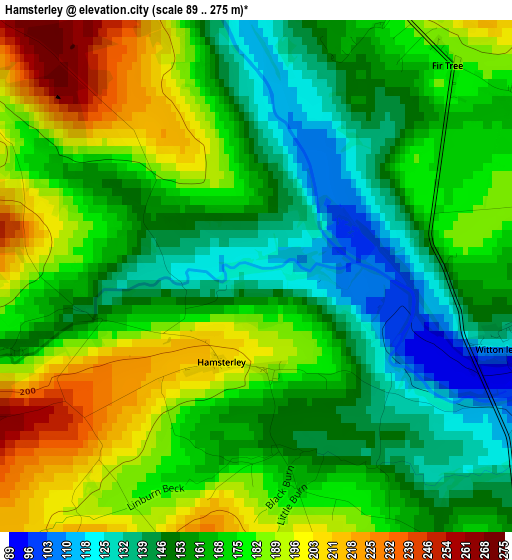
Below is the Elevation map of Hamsterley, which displays elevation range with different colors. Scale of the first map is from 89 to 275 m (292 to 902 ft) with average elevation of 168.3 meters (=552 ft) [note 1]
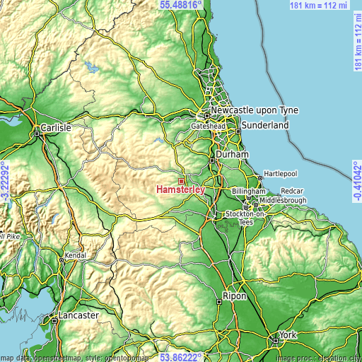
These maps also provides idea of topography and contour of this city, they are displayed at different zoom levels. More info about maps, scale and edge coordinates you can find below images.
| \ | Map #1 | Topo.Map |
| Scale [m] | 89..275 m | × |
| Scale [ft] | 292..902 ft | × |
| Average | 168.3 m = 552 ft | × |
| Width | 5.65 km = 3.5 mi | 180.8 km = 112.3 mi |
| Height | 5.65 km = 3.5 mi | 180.8 km = 112.3 mi |
| ↑Max Latitude | 54.708727° | 55.48816° |
| Latitude at center | 54.68333° | 54.68333° |
| ↓Min Latitude | 54.657917° | 53.86222° |
| ← Min Longitude | -1.860615° | -3.22292° |
| Longitude center | -1.81667° | -1.81667° |
| →Max Longitude | -1.772725° | -0.41042° |
Nearby cities:
Cities around Hamsterley sort by population:
• Bishop Auckland elevation 110 m
9.5 km,  108°
108°
• Crook 152 m
5.4 km,  52°
52°
• Willington 140 m
8.4 km,  63°
63°
• Coundon 175 m
12.4 km,  100°
100°
• Wolsingham 142 m
6.8 km,  321°
321°
• Tow Law 306 m
6.8 km,  1°
1°
• High Etherley 164 m
5.7 km,  124°
124°
• Low Etherley 167 m
5.8 km,  125°
125°
• Evenwood 165 m
7.7 km,  152°
152°
• Cockfield 224 m
7.8 km,  176°
176°
• Staindrop 114 m
11.4 km, 176°
• Hunwick 128 m
7.2 km,  85°
85°
Multilingual:
 En español:
Hamsterley elevación 121 m.
 En France:
Hamsterley élévation 121 m.
 Auf Deutsch:
Hamsterley höhe über dem Meeresspiegel ist 121 m.

Sources and notes:
- [note 1] Map square and city borders are not equal. Map elevation data is calculated only from area inside that square.
- [src 1] Elevation data from geonames database provided with same terms of usage.
- [src 2] The elevation map of Hamsterley is generated using elevation data from NASA's 3 arcsec (90m) resolution SRTM data.
- [src 3] Base (background) map © OpenStreetMap contributors tiles are generated by Geofabrik and OpenTopoMap.
Copyright & License:
This Hamsterley Elevation Map is licensed under CC BY-SA. You may reuse any part from this page, if you give a proper credit by linking to this URL:
 More info on terms of use page.