Hatfield elevation
Hatfield (England, Hertfordshire), United Kingdom elevation is 84 meters and Hatfield elevation in feet is 276 ft above sea level [src 1]. Hatfield is a populated place (feature code) with elevation that is 12 meters (39 ft) bigger than average city elevation in United Kingdom.
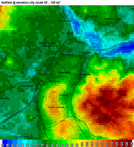
Below is the Elevation map of Hatfield, which displays elevation range with different colors. Scale of the first map is from 55 to 129 m (180 to 423 ft) with average elevation of 86.4 meters (=283 ft) [note 1]
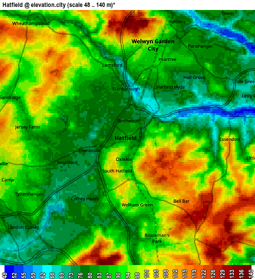
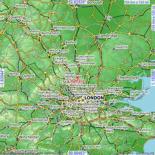
These maps also provides idea of topography and contour of this city, they are displayed at different zoom levels. More info about maps, scale and edge coordinates you can find below images.
| \ | Map #1 | Map #2 | Topo.Map |
| Scale [m] | 55..129 m | 48..140 m | × |
| Scale [ft] | 180..423 ft | 157..459 ft | × |
| Average | 86.4 m = 283 ft | 90.5 m = 297 ft | × |
| Width | 6.05 km = 3.8 mi | 12.1 km = 7.5 mi | 193.5 km = 120.2 mi |
| Height | 6.05 km = 3.8 mi | 12.1 km = 7.5 mi | 193.5 km = 120.2 mi |
| ↑Max Latitude | 51.79057° | 51.817744° | 52.62535° |
| Latitude at center | 51.76338° | 51.76338° | 51.76338° |
| ↓Min Latitude | 51.736174° | 51.708951° | 50.88463° |
| ← Min Longitude | -0.268135° | -0.312081° | -1.63044° |
| Longitude center | -0.22419° | -0.22419° | -0.22419° |
| →Max Longitude | -0.180245° | -0.136299° | 1.18206° |
Nearby cities:
Cities around Hatfield sort by population:
• St Albans elevation 98 m
7.7 km,  258°
258°
• Welwyn Garden City 92 m
4.4 km,  15°
15°
• Harpenden 107 m
10.9 km,  303°
303°
• Hertford 45 m
10.7 km,  70°
70°
• Potters Bar 125 m
8.4 km,  157°
157°
• Codicote 106 m
9.7 km,  354°
354°
• Radlett 74 m
10.8 km,  217°
217°
• Wheathampstead 91 m
7.2 km,  318°
318°
• Cuffley 69 m
9.9 km,  128°
128°
• Shenley 134 m
9 km,  205°
205°
• Welwyn 82 m
7.8 km,  5°
5°
• Datchworth 112 m
10.7 km, 24°
Multilingual:
 En español:
Hatfield elevación 84 m.
 En France:
Hatfield élévation 84 m.


Sources and notes:
- [note 1] Map square and city borders are not equal. Map elevation data is calculated only from area inside that square.
- [src 1] Elevation data from geonames database provided with same terms of usage.
- [src 2] The elevation map of Hatfield is generated using elevation data from NASA's 3 arcsec (90m) resolution SRTM data.
- [src 3] Base (background) map © OpenStreetMap contributors tiles are generated by Geofabrik and OpenTopoMap.
Copyright & License:
This Hatfield Elevation Map is licensed under CC BY-SA. You may reuse any part from this page, if you give a proper credit by linking to this URL:
 More info on terms of use page.