Hayle elevation
Hayle (England, Cornwall), United Kingdom elevation is 6 meters and Hayle elevation in feet is 20 ft above sea level [src 1]. Hayle is a populated place (feature code) with elevation that is 66 meters (217 ft) smaller than average city elevation in United Kingdom.
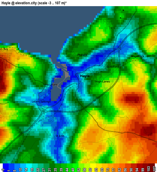
Below is the Elevation map of Hayle, which displays elevation range with different colors. Scale of the first map is from -3 to 107 m (-10 to 351 ft) with average elevation of 43 meters (=141 ft) [note 1]
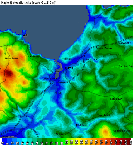
These maps also provides idea of topography and contour of this city, they are displayed at different zoom levels. More info about maps, scale and edge coordinates you can find below images.
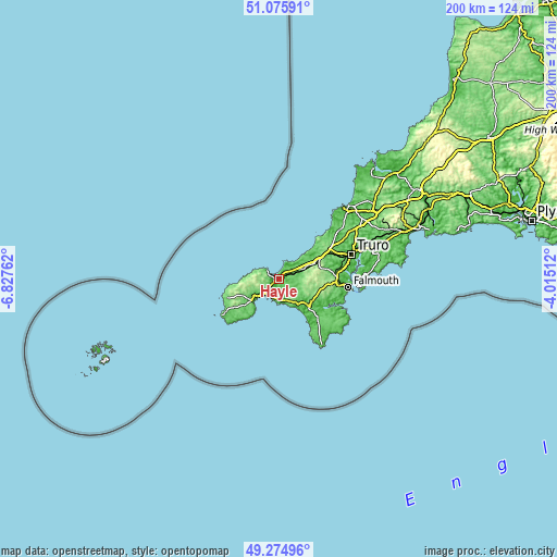
| \ | Map #1 | Map #2 | Topo.Map |
| Scale [m] | -3..107 m | -3..210 m | × |
| Scale [ft] | -10..351 ft | -10..689 ft | × |
| Average | 43 m = 141 ft | 61.9 m = 203 ft | × |
| Width | 6.26 km = 3.9 mi | 12.52 km = 7.8 mi | 200.2 km = 124.4 mi |
| Height | 6.26 km = 3.9 mi | 12.52 km = 7.8 mi | 200.2 km = 124.4 mi |
| ↑Max Latitude | 50.212051° | 50.240165° | 51.07591° |
| Latitude at center | 50.18392° | 50.18392° | 50.18392° |
| ↓Min Latitude | 50.155772° | 50.127608° | 49.27496° |
| ← Min Longitude | -5.465315° | -5.509261° | -6.82762° |
| Longitude center | -5.42137° | -5.42137° | -5.42137° |
| →Max Longitude | -5.377425° | -5.333479° | -4.01512° |
Nearby cities:
Cities around Hayle sort by population:
• Redruth elevation 135 m
15.1 km,  68°
68°
• Camborne 101 m
9.4 km, 69°
• Penzance 32 m
11 km,  228°
228°
• Helston 60 m
14 km,  129°
129°
• St Ives 83 m
5.4 km,  300°
300°
• Porthleven 12 m
13.3 km,  145°
145°
• Stithians 134 m
17.3 km,  88°
88°
• Four Lanes 216 m
13.1 km,  81°
81°
• Marazion 17 m
7.5 km,  210°
210°
• Uny Lelant 34 m
1.4 km,  265°
265°
• Germoe 76 m
8.2 km,  158°
158°
• Wendron 135 m
13.4 km,  114°
114°
Multilingual:
 En español:
Hayle elevación 6 m.
 En France:
Hayle élévation 6 m.


Sources and notes:
- [note 1] Map square and city borders are not equal. Map elevation data is calculated only from area inside that square.
- [src 1] Elevation data from geonames database provided with same terms of usage.
- [src 2] The elevation map of Hayle is generated using elevation data from NASA's 3 arcsec (90m) resolution SRTM data.
- [src 3] Base (background) map © OpenStreetMap contributors tiles are generated by Geofabrik and OpenTopoMap.
Copyright & License:
This Hayle Elevation Map is licensed under CC BY-SA. You may reuse any part from this page, if you give a proper credit by linking to this URL:
 More info on terms of use page.