Horrabridge elevation
Horrabridge (England, Devon), United Kingdom elevation is 99 meters and Horrabridge elevation in feet is 325 ft above sea level [src 1]. Horrabridge is a populated place (feature code) with elevation that is 27 meters (89 ft) bigger than average city elevation in United Kingdom.
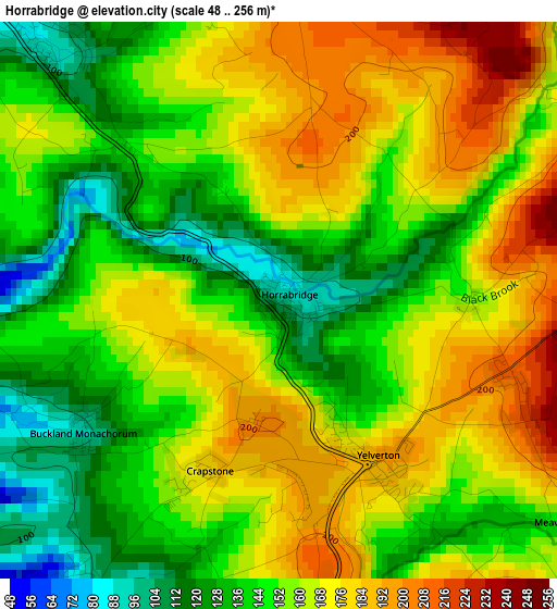
Below is the Elevation map of Horrabridge, which displays elevation range with different colors. Scale of the first map is from 48 to 256 m (157 to 840 ft) with average elevation of 156.2 meters (=512 ft) [note 1]
These maps also provides idea of topography and contour of this city, they are displayed at different zoom levels. More info about maps, scale and edge coordinates you can find below images.
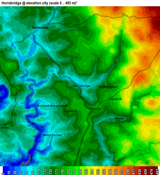
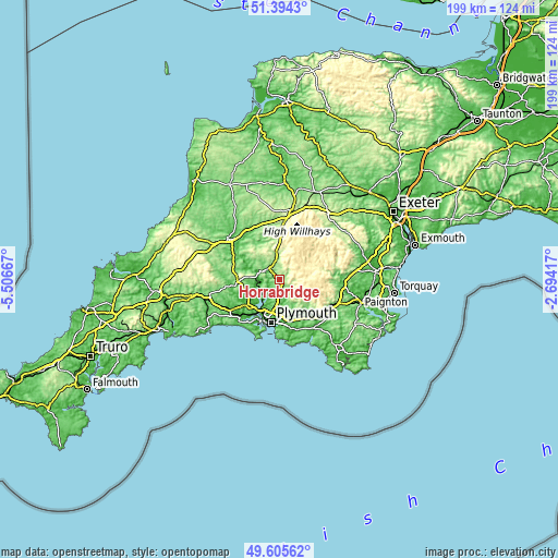
| \ | Map #1 | Map #2 | Topo.Map |
| Scale [m] | 48..256 m | 0..493 m | × |
| Scale [ft] | 157..840 ft | 0..1617 ft | × |
| Average | 156.2 m = 512 ft | 180.6 m = 593 ft | × |
| Width | 6.21 km = 3.9 mi | 12.43 km = 7.7 mi | 198.9 km = 123.6 mi |
| Height | 6.21 km = 3.9 mi | 12.43 km = 7.7 mi | 198.9 km = 123.6 mi |
| ↑Max Latitude | 50.536369° | 50.564292° | 51.3943° |
| Latitude at center | 50.50843° | 50.50843° | 50.50843° |
| ↓Min Latitude | 50.480474° | 50.452502° | 49.60562° |
| ← Min Longitude | -4.144365° | -4.188311° | -5.50667° |
| Longitude center | -4.10042° | -4.10042° | -4.10042° |
| →Max Longitude | -4.056475° | -4.012529° | -2.69417° |
Nearby cities:
Cities around Horrabridge sort by population:
• Plymouth elevation 14 m
15.5 km,  191°
191°
• Plymstock 27 m
16.5 km,  177°
177°
• Saltash 64 m
14.1 km,  218°
218°
• Tavistock 85 m
5.5 km,  325°
325°
• Plympton 22 m
13.4 km,  167°
167°
• Torpoint 14 m
16.3 km,  204°
204°
• Callington 161 m
15.1 km,  267°
267°
• Gunnislake 53 m
8.2 km,  282°
282°
• Yelverton 193 m
2.1 km,  145°
145°
• Bere Alston 139 m
7 km,  245°
245°
• Princetown 419 m
8.8 km,  63°
63°
• Pillaton 43 m
15.5 km, 245°
Multilingual:
 En español:
Horrabridge elevación 99 m.
 En France:
Horrabridge élévation 99 m.
 Auf Deutsch:
Horrabridge höhe über dem Meeresspiegel ist 99 m.

Sources and notes:
- [note 1] Map square and city borders are not equal. Map elevation data is calculated only from area inside that square.
- [src 1] Elevation data from geonames database provided with same terms of usage.
- [src 2] The elevation map of Horrabridge is generated using elevation data from NASA's 3 arcsec (90m) resolution SRTM data.
- [src 3] Base (background) map © OpenStreetMap contributors tiles are generated by Geofabrik and OpenTopoMap.
Copyright & License:
This Horrabridge Elevation Map is licensed under CC BY-SA. You may reuse any part from this page, if you give a proper credit by linking to this URL:
 More info on terms of use page.