Princetown elevation
Princetown (England, Devon), United Kingdom elevation is 419 meters and Princetown elevation in feet is 1375 ft above sea level [src 1]. Princetown is a populated place (feature code) with elevation that is 347 meters (1138 ft) bigger than average city elevation in United Kingdom.
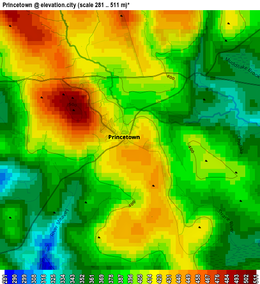
Below is the Elevation map of Princetown, which displays elevation range with different colors. Scale of the first map is from 281 to 511 m (922 to 1677 ft) with average elevation of 395.1 meters (=1296 ft) [note 1]
These maps also provides idea of topography and contour of this city, they are displayed at different zoom levels. More info about maps, scale and edge coordinates you can find below images.
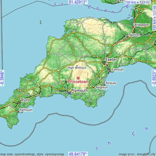
| \ | Map #1 | Topo.Map |
| Scale [m] | 281..511 m | × |
| Scale [ft] | 922..1677 ft | × |
| Average | 395.1 m = 1296 ft | × |
| Width | 6.21 km = 3.9 mi | 198.7 km = 123.5 mi |
| Height | 6.21 km = 3.9 mi | 198.7 km = 123.5 mi |
| ↑Max Latitude | 50.571848° | 51.42913° |
| Latitude at center | 50.54393° | 50.54393° |
| ↓Min Latitude | 50.515995° | 49.64179° |
| ← Min Longitude | -4.032495° | -5.3948° |
| Longitude center | -3.98855° | -3.98855° |
| →Max Longitude | -3.944605° | -2.5823° |
Nearby cities:
Cities around Princetown sort by population:
• Tavistock elevation 85 m
11 km,  273°
273°
• Ivybridge 63 m
17.8 km,  163°
163°
• Plympton 22 m
17.8 km,  196°
196°
• Gunnislake 53 m
16 km,  262°
262°
• Horrabridge 99 m
8.8 km,  243°
243°
• Buckfastleigh 42 m
16.4 km,  115°
115°
• Yelverton 193 m
8.8 km,  229°
229°
• Ashburton 76 m
16.8 km,  100°
100°
• South Brent 124 m
17 km,  140°
140°
• Bere Alston 139 m
15.8 km, 244°
• Moretonhampstead 202 m
20.4 km,  50°
50°
• Chagford 175 m
18 km,  35°
35°
Multilingual:
 En español:
Princetown elevación 419 m.
 En France:
Princetown élévation 419 m.
 Auf Deutsch:
Princetown höhe über dem Meeresspiegel ist 419 m.

Sources and notes:
- [note 1] Map square and city borders are not equal. Map elevation data is calculated only from area inside that square.
- [src 1] Elevation data from geonames database provided with same terms of usage.
- [src 2] The elevation map of Princetown is generated using elevation data from NASA's 3 arcsec (90m) resolution SRTM data.
- [src 3] Base (background) map © OpenStreetMap contributors tiles are generated by Geofabrik and OpenTopoMap.
Copyright & License:
This Princetown Elevation Map is licensed under CC BY-SA. You may reuse any part from this page, if you give a proper credit by linking to this URL:
 More info on terms of use page.