Inverkeithing elevation
Inverkeithing (Scotland, Fife), United Kingdom elevation is 20 meters and Inverkeithing elevation in feet is 66 ft above sea level [src 1]. Inverkeithing is a populated place (feature code) with elevation that is 52 meters (171 ft) smaller than average city elevation in United Kingdom.
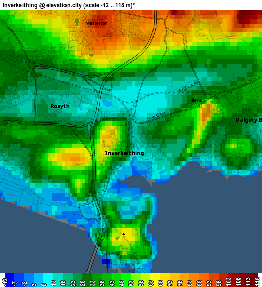
Below is the Elevation map of Inverkeithing, which displays elevation range with different colors. Scale of the first map is from -12 to 118 m (-39 to 387 ft) with average elevation of 37 meters (=121 ft) [note 1]
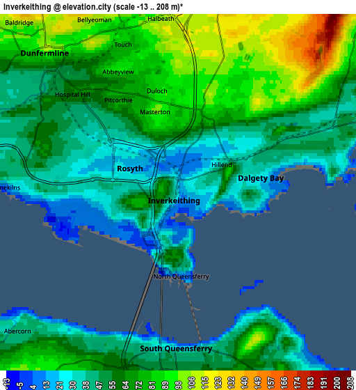
These maps also provides idea of topography and contour of this city, they are displayed at different zoom levels. More info about maps, scale and edge coordinates you can find below images.
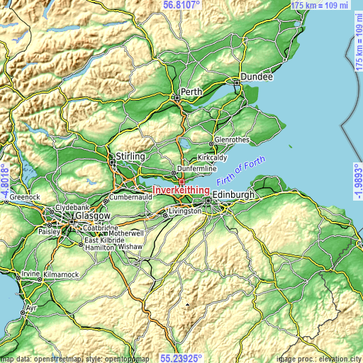
| \ | Map #1 | Map #2 | Topo.Map |
| Scale [m] | -12..118 m | -13..208 m | × |
| Scale [ft] | -39..387 ft | -43..682 ft | × |
| Average | 37 m = 121 ft | 60.3 m = 198 ft | × |
| Width | 5.46 km = 3.4 mi | 10.92 km = 6.8 mi | 174.7 km = 108.6 mi |
| Height | 5.46 km = 3.4 mi | 10.92 km = 6.8 mi | 174.7 km = 108.6 mi |
| ↑Max Latitude | 56.057515° | 56.082045° | 56.8107° |
| Latitude at center | 56.03297° | 56.03297° | 56.03297° |
| ↓Min Latitude | 56.008409° | 55.983833° | 55.23925° |
| ← Min Longitude | -3.439495° | -3.483441° | -4.8018° |
| Longitude center | -3.39555° | -3.39555° | -3.39555° |
| →Max Longitude | -3.351605° | -3.307659° | -1.9893° |
Nearby cities:
Cities around Inverkeithing sort by population:
• Dunfermline elevation 107 m
5.8 km,  317°
317°
• Rosyth 32 m
2.7 km,  279°
279°
• Dalgety Bay 13 m
2.8 km,  85°
85°
• Queensferry 9 m
4.7 km,  182°
182°
• Kirkliston 37 m
8.8 km, 182°
• Crossgates 121 m
5.8 km,  11°
11°
• Cairneyhill 38 m
9.1 km,  288°
288°
• Crossford 45 m
7.1 km,  298°
298°
• Aberdour 35 m
6.4 km,  68°
68°
• Limekilns 16 m
5.1 km,  270°
270°
• Townhill 136 m
6.8 km,  336°
336°
• North Queensferry 7 m
2.7 km,  174°
174°
Multilingual:
 En español:
Inverkeithing elevación 20 m.
 En France:
Inverkeithing élévation 20 m.
 Auf Deutsch:
Inverkeithing höhe über dem Meeresspiegel ist 20 m.

Sources and notes:
- [note 1] Map square and city borders are not equal. Map elevation data is calculated only from area inside that square.
- [src 1] Elevation data from geonames database provided with same terms of usage.
- [src 2] The elevation map of Inverkeithing is generated using elevation data from NASA's 3 arcsec (90m) resolution SRTM data.
- [src 3] Base (background) map © OpenStreetMap contributors tiles are generated by Geofabrik and OpenTopoMap.
Copyright & License:
This Inverkeithing Elevation Map is licensed under CC BY-SA. You may reuse any part from this page, if you give a proper credit by linking to this URL:
 More info on terms of use page.