Kemnay elevation
Kemnay (Scotland, Aberdeenshire), United Kingdom elevation is 88 meters and Kemnay elevation in feet is 289 ft above sea level [src 1]. Kemnay is a populated place (feature code) with elevation that is 16 meters (52 ft) bigger than average city elevation in United Kingdom.
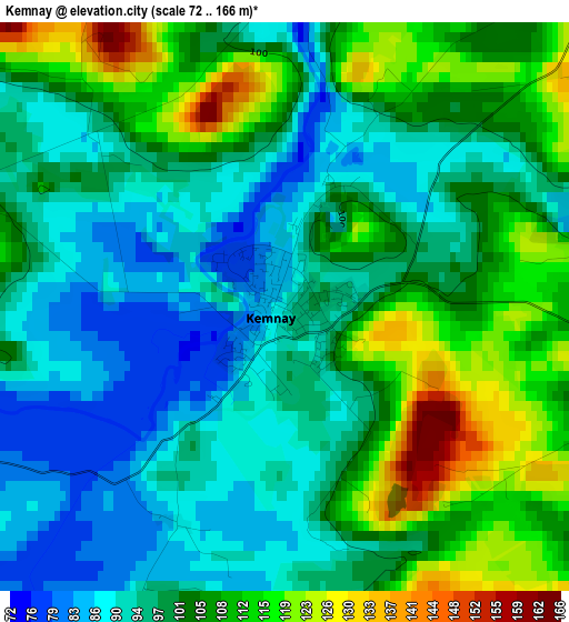
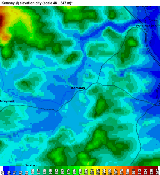
Below is the Elevation map of Kemnay, which displays elevation range with different colors. Scale of the first map is from 72 to 166 m (236 to 545 ft) with average elevation of 100.7 meters (=330 ft) [note 1]
These maps also provides idea of topography and contour of this city, they are displayed at different zoom levels. More info about maps, scale and edge coordinates you can find below images.
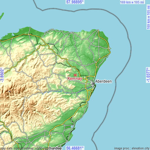
| \ | Map #1 | Map #2 | Topo.Map |
| Scale [m] | 72..166 m | 48..347 m | × |
| Scale [ft] | 236..545 ft | 157..1138 ft | × |
| Average | 100.7 m = 330 ft | 111.2 m = 365 ft | × |
| Width | 5.29 km = 3.3 mi | 10.58 km = 6.6 mi | 169.2 km = 105.1 mi |
| Height | 5.29 km = 3.3 mi | 10.58 km = 6.6 mi | 169.2 km = 105.1 mi |
| ↑Max Latitude | 57.259505° | 57.283264° | 57.98895° |
| Latitude at center | 57.23573° | 57.23573° | 57.23573° |
| ↓Min Latitude | 57.21194° | 57.188134° | 56.46681° |
| ← Min Longitude | -2.487895° | -2.531841° | -3.8502° |
| Longitude center | -2.44395° | -2.44395° | -2.44395° |
| →Max Longitude | -2.400005° | -2.356059° | -1.0377° |
Nearby cities:
Cities around Kemnay sort by population:
• Inverurie elevation 63 m
6.7 km,  36°
36°
• Westhill 127 m
13.5 km,  133°
133°
• Dyce 53 m
16.4 km,  101°
101°
• Kingswells 147 m
15.8 km,  123°
123°
• Kintore 51 m
5.9 km,  88°
88°
• Oldmeldrum 116 m
13.3 km,  34°
34°
• Blackburn 80 m
10 km,  110°
110°
• Newmacher 99 m
16 km,  77°
77°
• Insch 129 m
15.7 km,  319°
319°
• Alford 149 m
15.6 km,  268°
268°
• Torphins 132 m
18.1 km,  216°
216°
• Sauchen 134 m
6.4 km,  211°
211°
Multilingual:
 En español:
Kemnay elevación 88 m.
 En France:
Kemnay élévation 88 m.


Sources and notes:
- [note 1] Map square and city borders are not equal. Map elevation data is calculated only from area inside that square.
- [src 1] Elevation data from geonames database provided with same terms of usage.
- [src 2] The elevation map of Kemnay is generated using elevation data from NASA's 3 arcsec (90m) resolution SRTM data.
- [src 3] Base (background) map © OpenStreetMap contributors tiles are generated by Geofabrik and OpenTopoMap.
Copyright & License:
This Kemnay Elevation Map is licensed under CC BY-SA. You may reuse any part from this page, if you give a proper credit by linking to this URL:
 More info on terms of use page.