Dyce elevation
Dyce (Scotland, Aberdeen City), United Kingdom elevation is 53 meters and Dyce elevation in feet is 174 ft above sea level [src 1]. Dyce is a populated place (feature code) with elevation that is 19 meters (62 ft) smaller than average city elevation in United Kingdom.
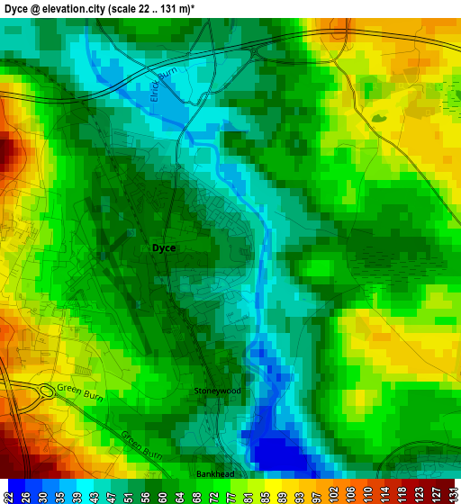
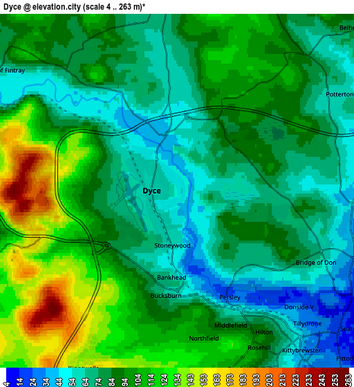
Below is the Elevation map of Dyce, which displays elevation range with different colors. Scale of the first map is from 22 to 131 m (72 to 430 ft) with average elevation of 65.9 meters (=216 ft) [note 1]
These maps also provides idea of topography and contour of this city, they are displayed at different zoom levels. More info about maps, scale and edge coordinates you can find below images.
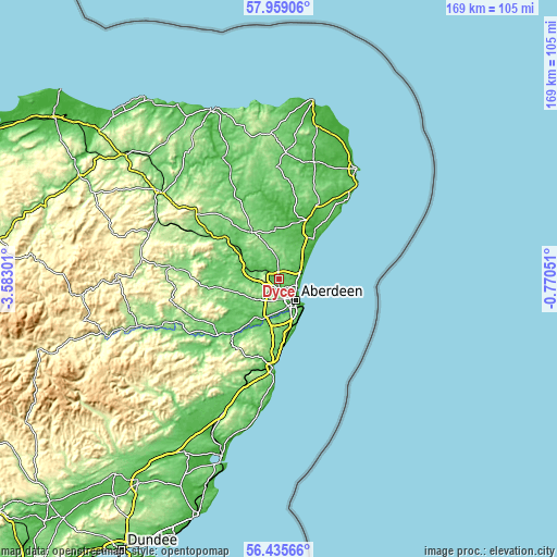
| \ | Map #1 | Map #2 | Topo.Map |
| Scale [m] | 22..131 m | 4..263 m | × |
| Scale [ft] | 72..430 ft | 13..863 ft | × |
| Average | 65.9 m = 216 ft | 88.8 m = 291 ft | × |
| Width | 5.29 km = 3.3 mi | 10.59 km = 6.6 mi | 169.4 km = 105.3 mi |
| Height | 5.29 km = 3.3 mi | 10.59 km = 6.6 mi | 169.4 km = 105.3 mi |
| ↑Max Latitude | 57.229014° | 57.252794° | 57.95906° |
| Latitude at center | 57.20522° | 57.20522° | 57.20522° |
| ↓Min Latitude | 57.18141° | 57.157585° | 56.43566° |
| ← Min Longitude | -2.220705° | -2.264651° | -3.58301° |
| Longitude center | -2.17676° | -2.17676° | -2.17676° |
| →Max Longitude | -2.132815° | -2.088869° | -0.77051° |
Nearby cities:
Cities around Dyce sort by population:
• Aberdeen elevation 13 m
8.3 km,  145°
145°
• Westhill 127 m
8.5 km,  226°
226°
• Cove 76 m
13 km, 154°
• Kingswells 147 m
6 km,  208°
208°
• Kintore 51 m
10.8 km,  289°
289°
• Peterculter 71 m
12.9 km,  204°
204°
• Cults 16 m
9.9 km,  176°
176°
• Blackburn 80 m
6.7 km,  268°
268°
• Milltimber 65 m
11.9 km, 199°
• Balmedie 34 m
8.6 km,  53°
53°
• Newmacher 99 m
6.8 km,  356°
356°
• Pitmedden 62 m
14.6 km, 359°
Multilingual:
 En español:
Dyce elevación 53 m.
 En France:
Dyce élévation 53 m.


Sources and notes:
- [note 1] Map square and city borders are not equal. Map elevation data is calculated only from area inside that square.
- [src 1] Elevation data from geonames database provided with same terms of usage.
- [src 2] The elevation map of Dyce is generated using elevation data from NASA's 3 arcsec (90m) resolution SRTM data.
- [src 3] Base (background) map © OpenStreetMap contributors tiles are generated by Geofabrik and OpenTopoMap.
Copyright & License:
This Dyce Elevation Map is licensed under CC BY-SA. You may reuse any part from this page, if you give a proper credit by linking to this URL:
 More info on terms of use page.