Larbert elevation
Larbert (Scotland, Falkirk), United Kingdom elevation is 34 meters and Larbert elevation in feet is 112 ft above sea level [src 1]. Larbert is a populated place (feature code) with elevation that is 38 meters (125 ft) smaller than average city elevation in United Kingdom.
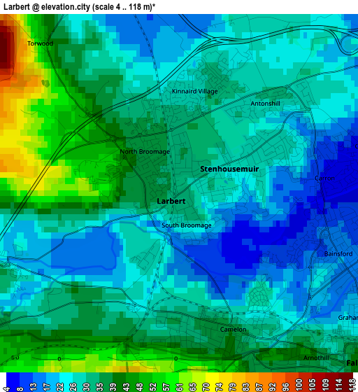
Below is the Elevation map of Larbert, which displays elevation range with different colors. Scale of the first map is from 4 to 118 m (13 to 387 ft) with average elevation of 31.9 meters (=105 ft) [note 1]
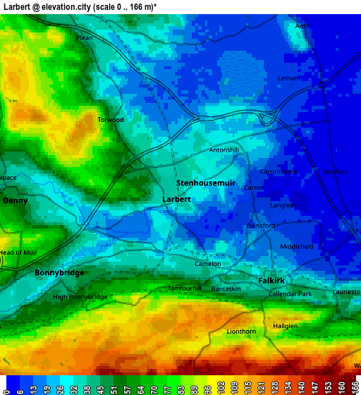
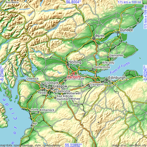
These maps also provides idea of topography and contour of this city, they are displayed at different zoom levels. More info about maps, scale and edge coordinates you can find below images.
| \ | Map #1 | Map #2 | Topo.Map |
| Scale [m] | 4..118 m | 0..166 m | × |
| Scale [ft] | 13..387 ft | 0..545 ft | × |
| Average | 31.9 m = 105 ft | 48.7 m = 160 ft | × |
| Width | 5.46 km = 3.4 mi | 10.92 km = 6.8 mi | 174.8 km = 108.6 mi |
| Height | 5.46 km = 3.4 mi | 10.92 km = 6.8 mi | 174.8 km = 108.6 mi |
| ↑Max Latitude | 56.047012° | 56.071548° | 56.8004° |
| Latitude at center | 56.02246° | 56.02246° | 56.02246° |
| ↓Min Latitude | 55.997893° | 55.97331° | 55.22852° |
| ← Min Longitude | -3.872665° | -3.916611° | -5.23497° |
| Longitude center | -3.82872° | -3.82872° | -3.82872° |
| →Max Longitude | -3.784775° | -3.740829° | -2.42247° |
Nearby cities:
Cities around Larbert sort by population:
• Falkirk elevation 25 m
3.5 km,  130°
130°
• Stenhousemuir 28 m
1 km,  61°
61°
• Denny 49 m
4.9 km,  271°
271°
• Bonnybridge 29 m
4.4 km,  237°
237°
• Hallglen 103 m
4.9 km,  146°
146°
• Carronshore 9 m
3 km,  70°
70°
• Laurieston 41 m
5.8 km,  120°
120°
• Dunipace 44 m
5.4 km,  275°
275°
• Carron 8 m
2.3 km,  79°
79°
• Greenhill 55 m
5.1 km,  228°
228°
• Plean 41 m
5.6 km,  328°
328°
• Head of Muir 80 m
5.6 km,  251°
251°
Multilingual:
 En español:
Larbert elevación 34 m.
 En France:
Larbert élévation 34 m.


Sources and notes:
- [note 1] Map square and city borders are not equal. Map elevation data is calculated only from area inside that square.
- [src 1] Elevation data from geonames database provided with same terms of usage.
- [src 2] The elevation map of Larbert is generated using elevation data from NASA's 3 arcsec (90m) resolution SRTM data.
- [src 3] Base (background) map © OpenStreetMap contributors tiles are generated by Geofabrik and OpenTopoMap.
Copyright & License:
This Larbert Elevation Map is licensed under CC BY-SA. You may reuse any part from this page, if you give a proper credit by linking to this URL:
 More info on terms of use page.