Letterston elevation
Letterston (Wales, Pembrokeshire), United Kingdom elevation is 131 meters and Letterston elevation in feet is 430 ft above sea level [src 1]. Letterston is a populated place (feature code) with elevation that is 59 meters (194 ft) bigger than average city elevation in United Kingdom.
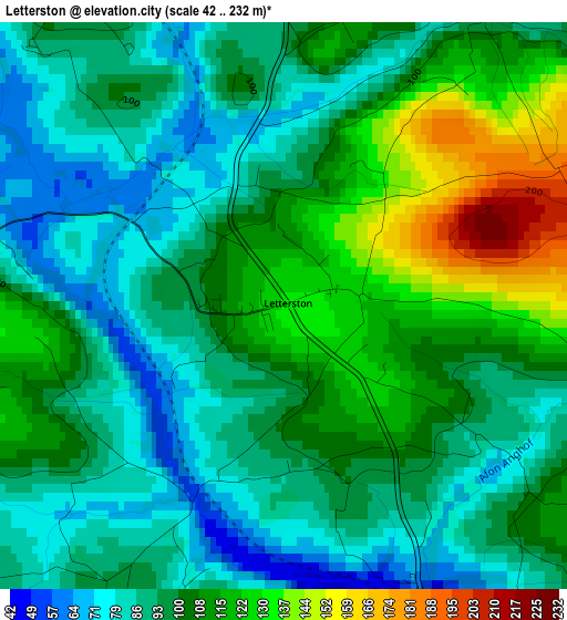
Below is the Elevation map of Letterston, which displays elevation range with different colors. Scale of the first map is from 42 to 232 m (138 to 761 ft) with average elevation of 100.6 meters (=330 ft) [note 1]
These maps also provides idea of topography and contour of this city, they are displayed at different zoom levels. More info about maps, scale and edge coordinates you can find below images.
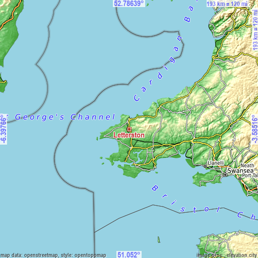
| \ | Map #1 | Topo.Map |
| Scale [m] | 42..232 m | × |
| Scale [ft] | 138..761 ft | × |
| Average | 100.6 m = 330 ft | × |
| Width | 6.03 km = 3.7 mi | 192.8 km = 119.8 mi |
| Height | 6.03 km = 3.7 mi | 192.8 km = 119.8 mi |
| ↑Max Latitude | 51.954661° | 52.78639° |
| Latitude at center | 51.92757° | 51.92757° |
| ↓Min Latitude | 51.900463° | 51.052° |
| ← Min Longitude | -5.035355° | -6.39766° |
| Longitude center | -4.99141° | -4.99141° |
| →Max Longitude | -4.947465° | -3.58516° |
Nearby cities:
Cities around Letterston sort by population:
• Haverfordwest elevation 17 m
14.1 km,  173°
173°
• Fishguard 63 m
7.4 km,  8°
8°
• Goodwick 25 m
8.6 km,  358°
358°
• Newport 32 m
14.7 km,  47°
47°
• Spittal 97 m
7.3 km,  152°
152°
• Nevern 31 m
16.9 km, 50°
• Wiston 109 m
14.1 km,  143°
143°
• Llanrhian 56 m
12.6 km,  275°
275°
• Camrose 48 m
9.7 km,  187°
187°
• Mathry 126 m
6.9 km,  287°
287°
• Ambleston 137 m
6.8 km,  121°
121°
• Scleddau 97 m
4.5 km, 358°
Multilingual:
 En español:
Letterston elevación 131 m.
 En France:
Letterston élévation 131 m.
 Auf Deutsch:
Letterston höhe über dem Meeresspiegel ist 131 m.

Sources and notes:
- [note 1] Map square and city borders are not equal. Map elevation data is calculated only from area inside that square.
- [src 1] Elevation data from geonames database provided with same terms of usage.
- [src 2] The elevation map of Letterston is generated using elevation data from NASA's 3 arcsec (90m) resolution SRTM data.
- [src 3] Base (background) map © OpenStreetMap contributors tiles are generated by Geofabrik and OpenTopoMap.
Copyright & License:
This Letterston Elevation Map is licensed under CC BY-SA. You may reuse any part from this page, if you give a proper credit by linking to this URL:
 More info on terms of use page.