Littleborough elevation
Littleborough (England, Borough of Rochdale), United Kingdom elevation is 150 meters and Littleborough elevation in feet is 492 ft above sea level [src 1]. Littleborough is a populated place (feature code) with elevation that is 78 meters (256 ft) bigger than average city elevation in United Kingdom.
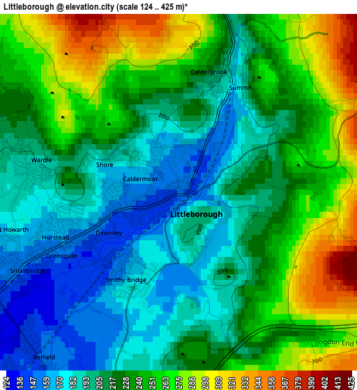
Below is the Elevation map of Littleborough, which displays elevation range with different colors. Scale of the first map is from 124 to 425 m (407 to 1394 ft) with average elevation of 225.1 meters (=739 ft) [note 1]
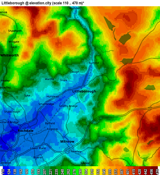
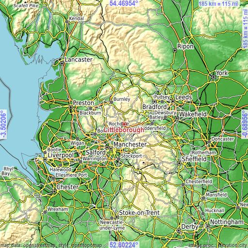
These maps also provides idea of topography and contour of this city, they are displayed at different zoom levels. More info about maps, scale and edge coordinates you can find below images.
| \ | Map #1 | Map #2 | Topo.Map |
| Scale [m] | 124..425 m | 110..470 m | × |
| Scale [ft] | 407..1394 ft | 361..1542 ft | × |
| Average | 225.1 m = 739 ft | 275.1 m = 903 ft | × |
| Width | 5.79 km = 3.6 mi | 11.59 km = 7.2 mi | 185.4 km = 115.2 mi |
| Height | 5.79 km = 3.6 mi | 11.59 km = 7.2 mi | 185.4 km = 115.2 mi |
| ↑Max Latitude | 53.670173° | 53.696199° | 54.46954° |
| Latitude at center | 53.64413° | 53.64413° | 53.64413° |
| ↓Min Latitude | 53.618071° | 53.591996° | 52.80224° |
| ← Min Longitude | -2.139755° | -2.183701° | -3.50206° |
| Longitude center | -2.09581° | -2.09581° | -2.09581° |
| →Max Longitude | -2.051865° | -2.007919° | -0.68956° |
Nearby cities:
Cities around Littleborough sort by population:
• Rochdale elevation 127 m
4.9 km,  233°
233°
• Heywood 121 m
10 km, 234°
• Royton 160 m
9 km,  191°
191°
• Milnrow 148 m
3.8 km,  196°
196°
• Bacup 257 m
9.5 km,  313°
313°
• Todmorden 129 m
7.8 km,  359°
359°
• Wardle 200 m
2.6 km,  284°
284°
• Whitworth 222 m
5.5 km, 283°
• Walsden 163 m
5.5 km, 357°
• Delph 204 m
10.1 km,  148°
148°
• Cornholme 190 m
10.2 km,  343°
343°
• Shaw 245 m
8.7 km,  174°
174°
Multilingual:
 En español:
Littleborough elevación 150 m.
 En France:
Littleborough élévation 150 m.
 Auf Deutsch:
Littleborough höhe über dem Meeresspiegel ist 150 m.

Sources and notes:
- [note 1] Map square and city borders are not equal. Map elevation data is calculated only from area inside that square.
- [src 1] Elevation data from geonames database provided with same terms of usage.
- [src 2] The elevation map of Littleborough is generated using elevation data from NASA's 3 arcsec (90m) resolution SRTM data.
- [src 3] Base (background) map © OpenStreetMap contributors tiles are generated by Geofabrik and OpenTopoMap.
Copyright & License:
This Littleborough Elevation Map is licensed under CC BY-SA. You may reuse any part from this page, if you give a proper credit by linking to this URL:
 More info on terms of use page.