Llangybi elevation
Llangybi (Wales, County of Ceredigion), United Kingdom elevation is 134 meters and Llangybi elevation in feet is 440 ft above sea level [src 1]. Llangybi is a seat of a third-order administrative division (feature code) with elevation that is 62 meters (203 ft) bigger than average city elevation in United Kingdom.
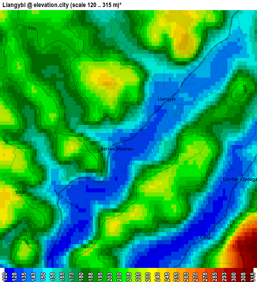
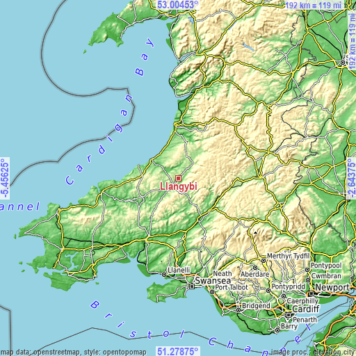
Below is the Elevation map of Llangybi, which displays elevation range with different colors. Scale of the first map is from 120 to 315 m (394 to 1033 ft) with average elevation of 181.5 meters (=595 ft) [note 1]
These maps also provides idea of topography and contour of this city, they are displayed at different zoom levels. More info about maps, scale and edge coordinates you can find below images.
| \ | Map #1 | Topo.Map |
| Scale [m] | 120..315 m | × |
| Scale [ft] | 394..1033 ft | × |
| Average | 181.5 m = 595 ft | × |
| Width | 6 km = 3.7 mi | 191.9 km = 119.2 mi |
| Height | 6 km = 3.7 mi | 191.9 km = 119.2 mi |
| ↑Max Latitude | 52.176957° | 53.00453° |
| Latitude at center | 52.15° | 52.15° |
| ↓Min Latitude | 52.123027° | 51.27875° |
| ← Min Longitude | -4.093945° | -5.45625° |
| Longitude center | -4.05° | -4.05° |
| →Max Longitude | -4.006055° | -2.64375° |
Nearby cities:
Cities around Llangybi sort by population:
• Lampeter elevation 123 m
4.6 km,  206°
206°
• Llandovery 68 m
24.5 km,  134°
134°
• Llandysul 80 m
21.4 km,  235°
235°
• Aberaeron 7 m
17.6 km,  305°
305°
• Tregaron 167 m
11.1 km,  45°
45°
• Pencader 117 m
22.2 km,  221°
221°
• Llanilar 40 m
23 km,  4°
4°
• New Quay 21 m
22.3 km,  288°
288°
• Llanarth 113 m
18.3 km, 285°
• Llanllwchaiarn 149 m
21.9 km,  279°
279°
• Lledrod 204 m
17.3 km,  15°
15°
• Llansawel 169 m
16.8 km,  172°
172°
Multilingual:
 En español:
Llangybi elevación 134 m.
 En France:
Llangybi élévation 134 m.
 Auf Deutsch:
Llangybi höhe über dem Meeresspiegel ist 134 m.

Sources and notes:
- [note 1] Map square and city borders are not equal. Map elevation data is calculated only from area inside that square.
- [src 1] Elevation data from geonames database provided with same terms of usage.
- [src 2] The elevation map of Llangybi is generated using elevation data from NASA's 3 arcsec (90m) resolution SRTM data.
- [src 3] Base (background) map © OpenStreetMap contributors tiles are generated by Geofabrik and OpenTopoMap.
Copyright & License:
This Llangybi Elevation Map is licensed under CC BY-SA. You may reuse any part from this page, if you give a proper credit by linking to this URL:
 More info on terms of use page.