Lledrod elevation
Lledrod (Wales, County of Ceredigion), United Kingdom elevation is 204 meters and Lledrod elevation in feet is 669 ft above sea level [src 1]. Lledrod is a seat of a third-order administrative division (feature code) with elevation that is 132 meters (433 ft) bigger than average city elevation in United Kingdom.
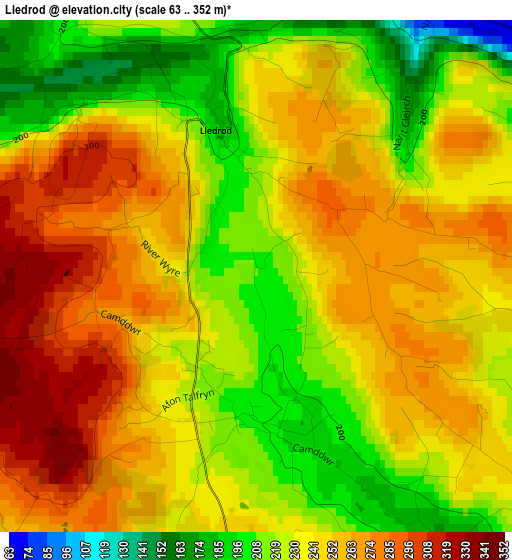
Below is the Elevation map of Lledrod, which displays elevation range with different colors. Scale of the first map is from 63 to 352 m (207 to 1155 ft) with average elevation of 241.8 meters (=793 ft) [note 1]
These maps also provides idea of topography and contour of this city, they are displayed at different zoom levels. More info about maps, scale and edge coordinates you can find below images.
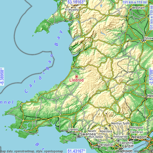
| \ | Map #1 | Topo.Map |
| Scale [m] | 63..352 m | × |
| Scale [ft] | 207..1155 ft | × |
| Average | 241.8 m = 793 ft | × |
| Width | 5.98 km = 3.7 mi | 191.2 km = 118.8 mi |
| Height | 5.98 km = 3.7 mi | 191.2 km = 118.8 mi |
| ↑Max Latitude | 52.326866° | 53.15163° |
| Latitude at center | 52.3° | 52.3° |
| ↓Min Latitude | 52.273118° | 51.43167° |
| ← Min Longitude | -4.027275° | -5.38958° |
| Longitude center | -3.98333° | -3.98333° |
| →Max Longitude | -3.939385° | -2.57708° |
Nearby cities:
Cities around Lledrod sort by population:
• Aberystwyth elevation 10 m
14.5 km,  332°
332°
• Penparcau 23 m
13 km, 331°
• Lampeter 123 m
21.8 km,  197°
197°
• Bow Street 29 m
16.1 km,  349°
349°
• Aberaeron 7 m
19.8 km,  251°
251°
• Borth 4 m
21.5 km, 347°
• Tregaron 167 m
9.6 km,  159°
159°
• Llanilar 40 m
6.9 km,  335°
335°
• New Quay 21 m
27.2 km, 249°
• Llanarth 113 m
25 km,  241°
241°
• Llanllwchaiarn 149 m
29.1 km, 243°
• Llangybi 134 m
17.3 km, 195°
Multilingual:
 En español:
Lledrod elevación 204 m.
 En France:
Lledrod élévation 204 m.


Sources and notes:
- [note 1] Map square and city borders are not equal. Map elevation data is calculated only from area inside that square.
- [src 1] Elevation data from geonames database provided with same terms of usage.
- [src 2] The elevation map of Lledrod is generated using elevation data from NASA's 3 arcsec (90m) resolution SRTM data.
- [src 3] Base (background) map © OpenStreetMap contributors tiles are generated by Geofabrik and OpenTopoMap.
Copyright & License:
This Lledrod Elevation Map is licensed under CC BY-SA. You may reuse any part from this page, if you give a proper credit by linking to this URL:
 More info on terms of use page.