Llangynog elevation
Llangynog (Wales, Sir Powys), United Kingdom elevation is 515 meters and Llangynog elevation in feet is 1690 ft above sea level [src 1]. Llangynog is a seat of a third-order administrative division (feature code) with elevation that is 443 meters (1453 ft) bigger than average city elevation in United Kingdom.
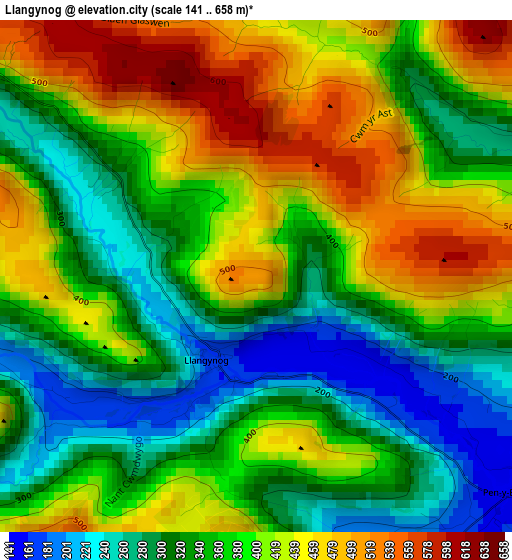
Below is the Elevation map of Llangynog, which displays elevation range with different colors. Scale of the first map is from 141 to 658 m (463 to 2159 ft) with average elevation of 373 meters (=1224 ft) [note 1]
These maps also provides idea of topography and contour of this city, they are displayed at different zoom levels. More info about maps, scale and edge coordinates you can find below images.
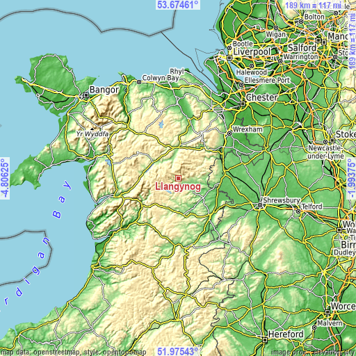
| \ | Map #1 | Topo.Map |
| Scale [m] | 141..658 m | × |
| Scale [ft] | 463..2159 ft | × |
| Average | 373 m = 1224 ft | × |
| Width | 5.9 km = 3.7 mi | 188.9 km = 117.4 mi |
| Height | 5.9 km = 3.7 mi | 188.9 km = 117.4 mi |
| ↑Max Latitude | 52.859871° | 53.67461° |
| Latitude at center | 52.83333° | 52.83333° |
| ↓Min Latitude | 52.806773° | 51.97543° |
| ← Min Longitude | -3.443945° | -4.80625° |
| Longitude center | -3.4° | -3.4° |
| →Max Longitude | -3.356055° | -1.99375° |
Nearby cities:
Cities around Llangynog sort by population:
• Llangollen elevation 99 m
21.5 km,  45°
45°
• Pant 108 m
22 km,  102°
102°
• Bala 168 m
15.8 km,  303°
303°
• Guilsfield 89 m
22.3 km,  132°
132°
• Llanfyllin 126 m
11.4 km, 131°
• Llanfair Caereinion 138 m
21.2 km,  166°
166°
• Llanrhaeadr-ym-Mochnant 155 m
6.6 km, 97°
• Derwen 284 m
22.2 km,  0°
0°
• Bryneglwys 247 m
21.8 km,  20°
20°
• Llangwm 409 m
18.9 km,  331°
331°
• Llanfechain 95 m
14.8 km,  116°
116°
• Llandrillo 162 m
10.3 km,  345°
345°
Multilingual:
 En español:
Llangynog elevación 515 m.
 En France:
Llangynog élévation 515 m.
 Auf Deutsch:
Llangynog höhe über dem Meeresspiegel ist 515 m.

Sources and notes:
- [note 1] Map square and city borders are not equal. Map elevation data is calculated only from area inside that square.
- [src 1] Elevation data from geonames database provided with same terms of usage.
- [src 2] The elevation map of Llangynog is generated using elevation data from NASA's 3 arcsec (90m) resolution SRTM data.
- [src 3] Base (background) map © OpenStreetMap contributors tiles are generated by Geofabrik and OpenTopoMap.
Copyright & License:
This Llangynog Elevation Map is licensed under CC BY-SA. You may reuse any part from this page, if you give a proper credit by linking to this URL:
 More info on terms of use page.