Pant elevation
Pant (England, Shropshire), United Kingdom elevation is 108 meters and Pant elevation in feet is 354 ft above sea level [src 1]. Pant is a populated place (feature code) with elevation that is 36 meters (118 ft) bigger than average city elevation in United Kingdom.
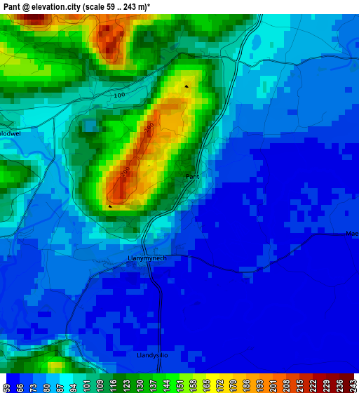
Below is the Elevation map of Pant, which displays elevation range with different colors. Scale of the first map is from 59 to 243 m (194 to 797 ft) with average elevation of 93 meters (=305 ft) [note 1]
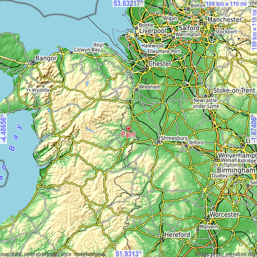
These maps also provides idea of topography and contour of this city, they are displayed at different zoom levels. More info about maps, scale and edge coordinates you can find below images.
| \ | Map #1 | Topo.Map |
| Scale [m] | 59..243 m | × |
| Scale [ft] | 194..797 ft | × |
| Average | 93 m = 305 ft | × |
| Width | 5.91 km = 3.7 mi | 189.1 km = 117.5 mi |
| Height | 5.91 km = 3.7 mi | 189.1 km = 117.5 mi |
| ↑Max Latitude | 52.816617° | 53.63217° |
| Latitude at center | 52.79005° | 52.79005° |
| ↓Min Latitude | 52.763467° | 51.9313° |
| ← Min Longitude | -3.124255° | -4.48656° |
| Longitude center | -3.08031° | -3.08031° |
| →Max Longitude | -3.036365° | -1.67406° |
Nearby cities:
Cities around Pant sort by population:
• Oswestry elevation 136 m
8.2 km,  12°
12°
• Welshpool 84 m
15.2 km,  197°
197°
• Gobowen 110 m
12.2 km, 13°
• Baschurch 84 m
15.3 km,  90°
90°
• Whittington 93 m
10.6 km,  29°
29°
• Four Crosses 70 m
3.4 km,  180°
180°
• Guilsfield 89 m
11.6 km,  206°
206°
• Llanfyllin 126 m
13.2 km,  258°
258°
• Ruyton-XI-Towns 78 m
11.9 km, 87°
• Westbury 134 m
15 km,  145°
145°
• Great Ness 91 m
13 km,  102°
102°
• Llanfechain 95 m
8.4 km, 258°
Multilingual:
 En español:
Pant elevación 108 m.
 En France:
Pant élévation 108 m.


Sources and notes:
- [note 1] Map square and city borders are not equal. Map elevation data is calculated only from area inside that square.
- [src 1] Elevation data from geonames database provided with same terms of usage.
- [src 2] The elevation map of Pant is generated using elevation data from NASA's 3 arcsec (90m) resolution SRTM data.
- [src 3] Base (background) map © OpenStreetMap contributors tiles are generated by Geofabrik and OpenTopoMap.
Copyright & License:
This Pant Elevation Map is licensed under CC BY-SA. You may reuse any part from this page, if you give a proper credit by linking to this URL:
 More info on terms of use page.