Mitcheldean elevation
Mitcheldean (England, Gloucestershire), United Kingdom elevation is 154 meters and Mitcheldean elevation in feet is 505 ft above sea level [src 1]. Mitcheldean is a populated place (feature code) with elevation that is 82 meters (269 ft) bigger than average city elevation in United Kingdom.
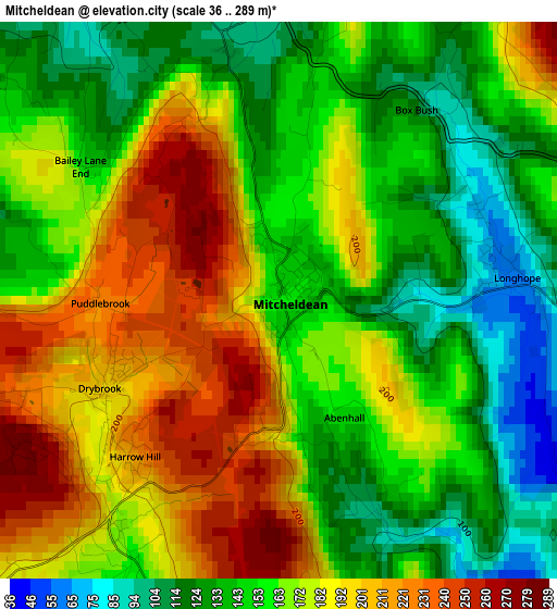
Below is the Elevation map of Mitcheldean, which displays elevation range with different colors. Scale of the first map is from 36 to 289 m (118 to 948 ft) with average elevation of 166 meters (=545 ft) [note 1]
These maps also provides idea of topography and contour of this city, they are displayed at different zoom levels. More info about maps, scale and edge coordinates you can find below images.
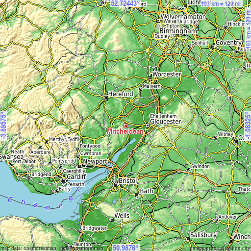
| \ | Map #1 | Topo.Map |
| Scale [m] | 36..289 m | × |
| Scale [ft] | 118..948 ft | × |
| Average | 166 m = 545 ft | × |
| Width | 6.03 km = 3.7 mi | 193.1 km = 120 mi |
| Height | 6.03 km = 3.7 mi | 193.1 km = 120 mi |
| ↑Max Latitude | 51.891529° | 52.72443° |
| Latitude at center | 51.8644° | 51.8644° |
| ↓Min Latitude | 51.837254° | 50.9876° |
| ← Min Longitude | -2.533445° | -3.89575° |
| Longitude center | -2.4895° | -2.4895° |
| →Max Longitude | -2.445555° | -1.08325° |
Nearby cities:
Cities around Mitcheldean sort by population:
• Cinderford elevation 210 m
4.5 km,  188°
188°
• Ross on Wye 39 m
7.9 km,  317°
317°
• Newent 41 m
9.5 km,  35°
35°
• Lydbrook 86 m
6.8 km,  243°
243°
• Ruardean 217 m
4.3 km,  256°
256°
• Drybrook 194 m
2.1 km, 242°
• Huntley 53 m
6.1 km,  82°
82°
• Longhope 72 m
2.7 km, 84°
• Marstow 47 m
11 km,  271°
271°
• Walford 35 m
7.9 km,  285°
285°
• Linton 110 m
6.8 km,  355°
355°
• Lea 112 m
4 km,  349°
349°
Multilingual:
 En español:
Mitcheldean elevación 154 m.
 En France:
Mitcheldean élévation 154 m.
 Auf Deutsch:
Mitcheldean höhe über dem Meeresspiegel ist 154 m.

Sources and notes:
- [note 1] Map square and city borders are not equal. Map elevation data is calculated only from area inside that square.
- [src 1] Elevation data from geonames database provided with same terms of usage.
- [src 2] The elevation map of Mitcheldean is generated using elevation data from NASA's 3 arcsec (90m) resolution SRTM data.
- [src 3] Base (background) map © OpenStreetMap contributors tiles are generated by Geofabrik and OpenTopoMap.
Copyright & License:
This Mitcheldean Elevation Map is licensed under CC BY-SA. You may reuse any part from this page, if you give a proper credit by linking to this URL:
 More info on terms of use page.