Nelson elevation
Nelson (England, Lancashire), United Kingdom elevation is 170 meters and Nelson elevation in feet is 558 ft above sea level [src 1]. Nelson is a populated place (feature code) with elevation that is 98 meters (322 ft) bigger than average city elevation in United Kingdom.
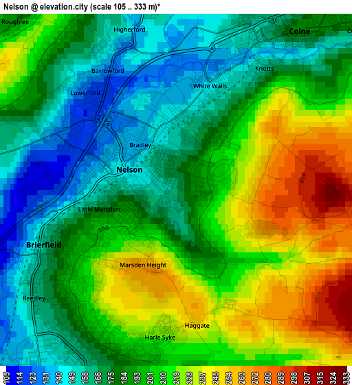
Below is the Elevation map of Nelson, which displays elevation range with different colors. Scale of the first map is from 105 to 333 m (344 to 1093 ft) with average elevation of 195.2 meters (=640 ft) [note 1]
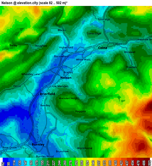
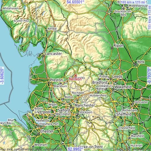
These maps also provides idea of topography and contour of this city, they are displayed at different zoom levels. More info about maps, scale and edge coordinates you can find below images.
| \ | Map #1 | Map #2 | Topo.Map |
| Scale [m] | 105..333 m | 82..502 m | × |
| Scale [ft] | 344..1093 ft | 269..1647 ft | × |
| Average | 195.2 m = 640 ft | 224.5 m = 737 ft | × |
| Width | 5.77 km = 3.6 mi | 11.53 km = 7.2 mi | 184.6 km = 114.7 mi |
| Height | 5.77 km = 3.6 mi | 11.53 km = 7.2 mi | 184.5 km = 114.6 mi |
| ↑Max Latitude | 53.859256° | 53.885165° | 54.65501° |
| Latitude at center | 53.83333° | 53.83333° | 53.83333° |
| ↓Min Latitude | 53.807388° | 53.78143° | 52.9952° |
| ← Min Longitude | -2.243945° | -2.287891° | -3.60625° |
| Longitude center | -2.2° | -2.2° | -2.2° |
| →Max Longitude | -2.156055° | -2.112109° | -0.79375° |
Nearby cities:
Cities around Nelson sort by population:
• Burnley elevation 140 m
4.3 km,  210°
210°
• Colne 191 m
3.4 km,  37°
37°
• Padiham 88 m
8.3 km,  245°
245°
• Barnoldswick 161 m
9.4 km,  5°
5°
• Brierfield 156 m
2.4 km, 246°
• Barrowford 117 m
1.9 km,  320°
320°
• Earby 138 m
9.9 km,  22°
22°
• Hapton 137 m
9.5 km,  234°
234°
• Cornholme 190 m
11.9 km,  160°
160°
• Hameldon Hill 401 m
10.5 km, 214°
• Sabden 154 m
9 km,  270°
270°
• Foulridge 176 m
5.1 km, 23°
Multilingual:
 En español:
Nelson elevación 170 m.
 En France:
Nelson élévation 170 m.


Sources and notes:
- [note 1] Map square and city borders are not equal. Map elevation data is calculated only from area inside that square.
- [src 1] Elevation data from geonames database provided with same terms of usage.
- [src 2] The elevation map of Nelson is generated using elevation data from NASA's 3 arcsec (90m) resolution SRTM data.
- [src 3] Base (background) map © OpenStreetMap contributors tiles are generated by Geofabrik and OpenTopoMap.
Copyright & License:
This Nelson Elevation Map is licensed under CC BY-SA. You may reuse any part from this page, if you give a proper credit by linking to this URL:
 More info on terms of use page.