Norbury elevation
Norbury (England, Shropshire), United Kingdom elevation is 267 meters and Norbury elevation in feet is 876 ft above sea level [src 1]. Norbury is a seat of a third-order administrative division (feature code) with elevation that is 195 meters (640 ft) bigger than average city elevation in United Kingdom.
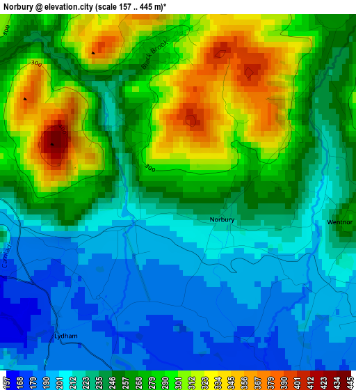
Below is the Elevation map of Norbury, which displays elevation range with different colors. Scale of the first map is from 157 to 445 m (515 to 1460 ft) with average elevation of 251.1 meters (=824 ft) [note 1]
These maps also provides idea of topography and contour of this city, they are displayed at different zoom levels. More info about maps, scale and edge coordinates you can find below images.
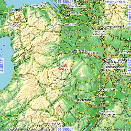
| \ | Map #1 | Topo.Map |
| Scale [m] | 157..445 m | × |
| Scale [ft] | 515..1460 ft | × |
| Average | 251.1 m = 824 ft | × |
| Width | 5.94 km = 3.7 mi | 190.2 km = 118.2 mi |
| Height | 5.94 km = 3.7 mi | 190.2 km = 118.2 mi |
| ↑Max Latitude | 52.560054° | 53.38044° |
| Latitude at center | 52.53333° | 52.53333° |
| ↓Min Latitude | 52.50659° | 51.66955° |
| ← Min Longitude | -2.993945° | -4.35625° |
| Longitude center | -2.95° | -2.95° |
| →Max Longitude | -2.906055° | -1.54375° |
Nearby cities:
Cities around Norbury sort by population:
• Church Stretton elevation 189 m
10.1 km,  87°
87°
• Craven Arms 123 m
12.7 km,  142°
142°
• Bishop's Castle 200 m
5.8 km,  217°
217°
• Pontesbury 108 m
13.4 km,  17°
17°
• Minsterley 107 m
11.9 km,  7°
7°
• Acton 254 m
10.3 km,  205°
205°
• Great Hanwood 76 m
19 km,  28°
28°
• Westbury 134 m
16.2 km,  358°
358°
• Longnor 124 m
15.4 km,  61°
61°
• Cardington 212 m
14.8 km,  82°
82°
• Mainstone 385 m
10.6 km,  238°
238°
• Lydham 182 m
2.9 km, 224°
Multilingual:
 En español:
Norbury elevación 267 m.
 En France:
Norbury élévation 267 m.


Sources and notes:
- [note 1] Map square and city borders are not equal. Map elevation data is calculated only from area inside that square.
- [src 1] Elevation data from geonames database provided with same terms of usage.
- [src 2] The elevation map of Norbury is generated using elevation data from NASA's 3 arcsec (90m) resolution SRTM data.
- [src 3] Base (background) map © OpenStreetMap contributors tiles are generated by Geofabrik and OpenTopoMap.
Copyright & License:
This Norbury Elevation Map is licensed under CC BY-SA. You may reuse any part from this page, if you give a proper credit by linking to this URL:
 More info on terms of use page.