Okehampton elevation
Okehampton (England, Devon), United Kingdom elevation is 156 meters and Okehampton elevation in feet is 512 ft above sea level [src 1]. Okehampton is a populated place (feature code) with elevation that is 84 meters (276 ft) bigger than average city elevation in United Kingdom.
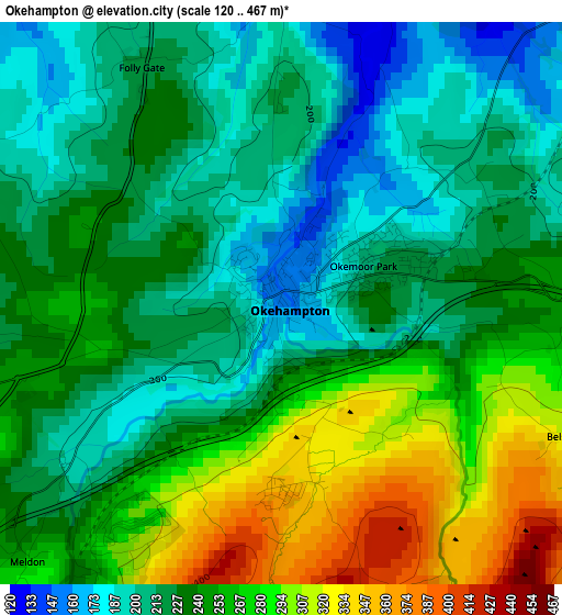
Below is the Elevation map of Okehampton, which displays elevation range with different colors. Scale of the first map is from 120 to 467 m (394 to 1532 ft) with average elevation of 241 meters (=791 ft) [note 1]
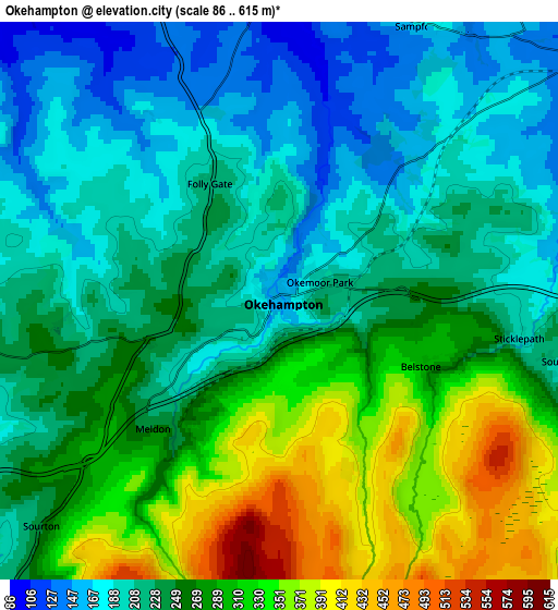
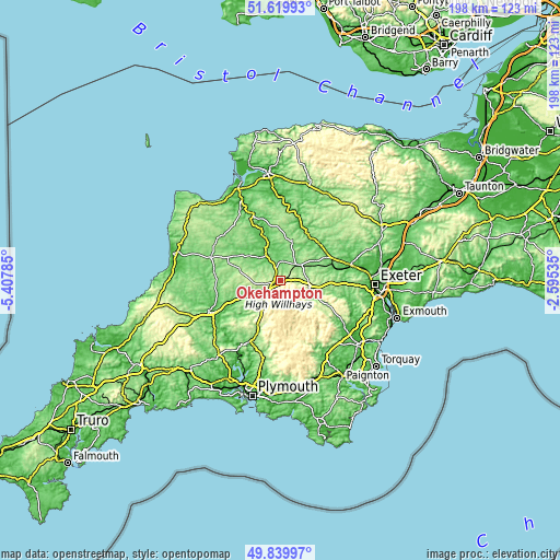
These maps also provides idea of topography and contour of this city, they are displayed at different zoom levels. More info about maps, scale and edge coordinates you can find below images.
| \ | Map #1 | Map #2 | Topo.Map |
| Scale [m] | 120..467 m | 86..615 m | × |
| Scale [ft] | 394..1532 ft | 282..2018 ft | × |
| Average | 241 m = 791 ft | 253.9 m = 833 ft | × |
| Width | 6.18 km = 3.8 mi | 12.37 km = 7.7 mi | 197.9 km = 123 mi |
| Height | 6.18 km = 3.8 mi | 12.37 km = 7.7 mi | 197.9 km = 123 mi |
| ↑Max Latitude | 50.766213° | 50.794° | 51.61993° |
| Latitude at center | 50.73841° | 50.73841° | 50.73841° |
| ↓Min Latitude | 50.71059° | 50.682754° | 49.83997° |
| ← Min Longitude | -4.045545° | -4.089491° | -5.40785° |
| Longitude center | -4.0016° | -4.0016° | -4.0016° |
| →Max Longitude | -3.957655° | -3.913709° | -2.59535° |
Nearby cities:
Cities around Okehampton sort by population:
• Tavistock elevation 85 m
23.3 km,  205°
205°
• North Tawton 138 m
10 km,  47°
47°
• Hatherleigh 81 m
10.5 km,  331°
331°
• Princetown 419 m
21.6 km,  177°
177°
• Moretonhampstead 202 m
18.8 km,  117°
117°
• Winkleigh 168 m
13.7 km,  17°
17°
• Copplestone 110 m
19.7 km,  65°
65°
• Lifton 75 m
22.4 km,  241°
241°
• Bow 127 m
14.7 km,  62°
62°
• Morchard Bishop 164 m
21.9 km, 54°
• Chagford 175 m
13.4 km, 121°
• Chulmleigh 137 m
21.5 km,  25°
25°
Multilingual:
 En español:
Okehampton elevación 156 m.
 En France:
Okehampton élévation 156 m.
 Auf Deutsch:
Okehampton höhe über dem Meeresspiegel ist 156 m.

Sources and notes:
- [note 1] Map square and city borders are not equal. Map elevation data is calculated only from area inside that square.
- [src 1] Elevation data from geonames database provided with same terms of usage.
- [src 2] The elevation map of Okehampton is generated using elevation data from NASA's 3 arcsec (90m) resolution SRTM data.
- [src 3] Base (background) map © OpenStreetMap contributors tiles are generated by Geofabrik and OpenTopoMap.
Copyright & License:
This Okehampton Elevation Map is licensed under CC BY-SA. You may reuse any part from this page, if you give a proper credit by linking to this URL:
 More info on terms of use page.