Omagh elevation
Omagh (Northern Ireland, Fermanagh and Omagh), United Kingdom elevation is 72 meters and Omagh elevation in feet is 236 ft above sea level [src 1]. Omagh is a seat of a second-order administrative division (feature code) with elevation that is 0 meters (0 ft) bigger than average city elevation in United Kingdom.
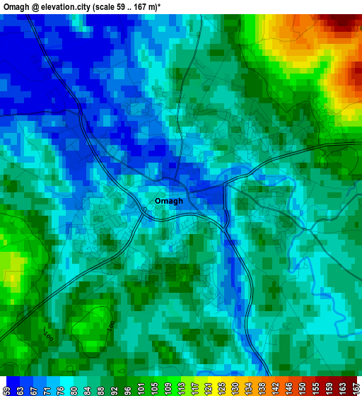
Below is the Elevation map of Omagh, which displays elevation range with different colors. Scale of the first map is from 59 to 167 m (194 to 548 ft) with average elevation of 85.4 meters (=280 ft) [note 1]
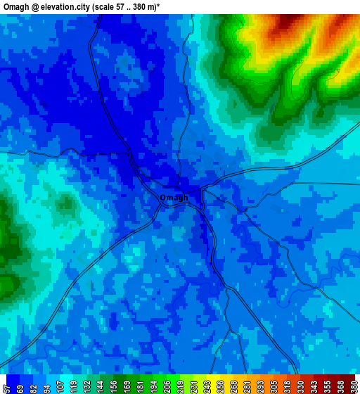
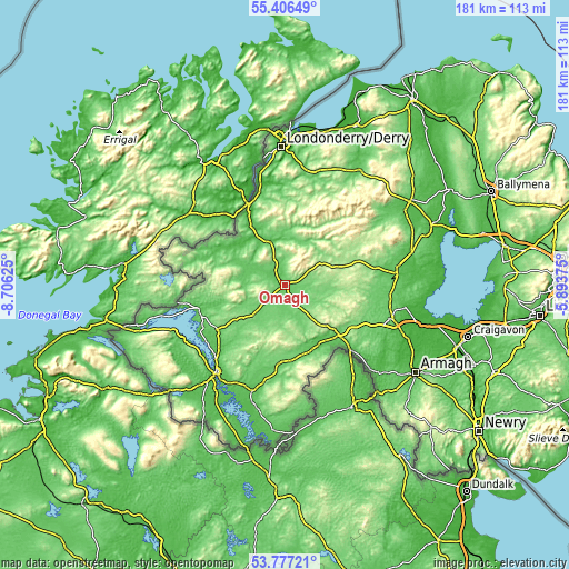
These maps also provides idea of topography and contour of this city, they are displayed at different zoom levels. More info about maps, scale and edge coordinates you can find below images.
| \ | Map #1 | Map #2 | Topo.Map |
| Scale [m] | 59..167 m | 57..380 m | × |
| Scale [ft] | 194..548 ft | 187..1247 ft | × |
| Average | 85.4 m = 280 ft | 105.6 m = 346 ft | × |
| Width | 5.66 km = 3.5 mi | 11.32 km = 7 mi | 181.2 km = 112.6 mi |
| Height | 5.66 km = 3.5 mi | 11.32 km = 7 mi | 181.1 km = 112.5 mi |
| ↑Max Latitude | 54.625449° | 54.650882° | 55.40649° |
| Latitude at center | 54.6° | 54.6° | 54.6° |
| ↓Min Latitude | 54.574535° | 54.549055° | 53.77721° |
| ← Min Longitude | -7.343945° | -7.387891° | -8.70625° |
| Longitude center | -7.3° | -7.3° | -7.3° |
| →Max Longitude | -7.256055° | -7.212109° | -5.89375° |
Nearby cities:
Cities around Omagh sort by population:
• Enniskillen elevation 52 m
35.8 km,  218°
218°
• Strabane 7 m
27.1 km,  336°
336°
• Dungannon 105 m
36 km,  107°
107°
• Cookstown 78 m
36 km,  82°
82°
• Dromore 104 m
14.1 km,  226°
226°
• Castlederg 47 m
22.3 km,  302°
302°
• Sion Mills 30 m
23.6 km,  331°
331°
• Irvinestown 89 m
26.1 km,  235°
235°
• Newtownstewart 53 m
14 km, 338°
• Fintona 117 m
11.2 km,  185°
185°
• Ballinamallard 109 m
28.8 km, 219°
• Fivemiletown 117 m
24.1 km,  180°
180°
Multilingual:
 En español:
Omagh elevación 72 m.
 En France:
Omagh élévation 72 m.


Sources and notes:
- [note 1] Map square and city borders are not equal. Map elevation data is calculated only from area inside that square.
- [src 1] Elevation data from geonames database provided with same terms of usage.
- [src 2] The elevation map of Omagh is generated using elevation data from NASA's 3 arcsec (90m) resolution SRTM data.
- [src 3] Base (background) map © OpenStreetMap contributors tiles are generated by Geofabrik and OpenTopoMap.
Copyright & License:
This Omagh Elevation Map is licensed under CC BY-SA. You may reuse any part from this page, if you give a proper credit by linking to this URL:
 More info on terms of use page.