Pelton elevation
Pelton (England, County Durham), United Kingdom elevation is 87 meters and Pelton elevation in feet is 285 ft above sea level [src 1]. Pelton is a seat of a third-order administrative division (feature code) with elevation that is 15 meters (49 ft) bigger than average city elevation in United Kingdom.
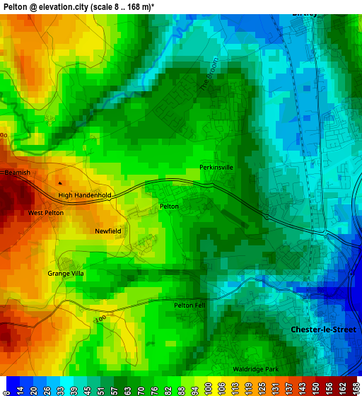
Below is the Elevation map of Pelton, which displays elevation range with different colors. Scale of the first map is from 8 to 168 m (26 to 551 ft) with average elevation of 72.3 meters (=237 ft) [note 1]
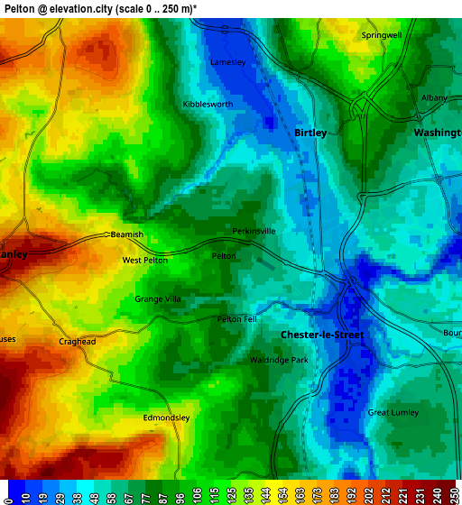
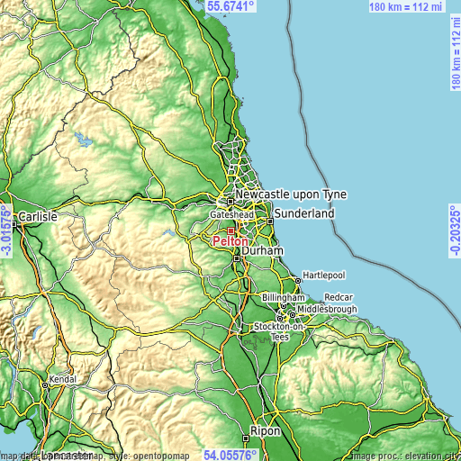
These maps also provides idea of topography and contour of this city, they are displayed at different zoom levels. More info about maps, scale and edge coordinates you can find below images.
| \ | Map #1 | Map #2 | Topo.Map |
| Scale [m] | 8..168 m | 0..250 m | × |
| Scale [ft] | 26..551 ft | 0..820 ft | × |
| Average | 72.3 m = 237 ft | 96 m = 315 ft | × |
| Width | 5.62 km = 3.5 mi | 11.25 km = 7 mi | 179.9 km = 111.8 mi |
| Height | 5.62 km = 3.5 mi | 11.25 km = 7 mi | 179.9 km = 111.8 mi |
| ↑Max Latitude | 54.898328° | 54.92359° | 55.6741° |
| Latitude at center | 54.87305° | 54.87305° | 54.87305° |
| ↓Min Latitude | 54.847756° | 54.822447° | 54.05576° |
| ← Min Longitude | -1.653445° | -1.697391° | -3.01575° |
| Longitude center | -1.6095° | -1.6095° | -1.6095° |
| →Max Longitude | -1.565555° | -1.521609° | -0.20325° |
Nearby cities:
Cities around Pelton sort by population:
• Washington elevation 59 m
6.7 km,  63°
63°
• Chester-le-Street 13 m
2.8 km,  125°
125°
• Felling 42 m
9.2 km,  15°
15°
• Stanley 225 m
5.7 km,  264°
264°
• Whickham 119 m
9.1 km,  332°
332°
• Annfield Plain 237 m
8.4 km, 258°
• Sacriston 154 m
6.2 km,  188°
188°
• Langley Park 102 m
9 km,  205°
205°
• Lamesley 12 m
4.7 km,  0°
0°
• Burnopfield 182 m
8.2 km,  296°
296°
• Witton Gilbert 108 m
7.7 km, 193°
• Tanfield 191 m
7 km,  288°
288°
Multilingual:
 En español:
Pelton elevación 87 m.
 En France:
Pelton élévation 87 m.


Sources and notes:
- [note 1] Map square and city borders are not equal. Map elevation data is calculated only from area inside that square.
- [src 1] Elevation data from geonames database provided with same terms of usage.
- [src 2] The elevation map of Pelton is generated using elevation data from NASA's 3 arcsec (90m) resolution SRTM data.
- [src 3] Base (background) map © OpenStreetMap contributors tiles are generated by Geofabrik and OpenTopoMap.
Copyright & License:
This Pelton Elevation Map is licensed under CC BY-SA. You may reuse any part from this page, if you give a proper credit by linking to this URL:
 More info on terms of use page.