Penryn elevation
Penryn (England, Cornwall), United Kingdom elevation is 29 meters and Penryn elevation in feet is 95 ft above sea level [src 1]. Penryn is a populated place (feature code) with elevation that is 43 meters (141 ft) smaller than average city elevation in United Kingdom.
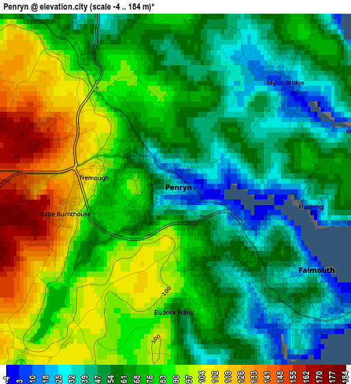
Below is the Elevation map of Penryn, which displays elevation range with different colors. Scale of the first map is from -4 to 184 m (-13 to 604 ft) with average elevation of 72.5 meters (=238 ft) [note 1]
These maps also provides idea of topography and contour of this city, they are displayed at different zoom levels. More info about maps, scale and edge coordinates you can find below images.
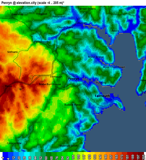
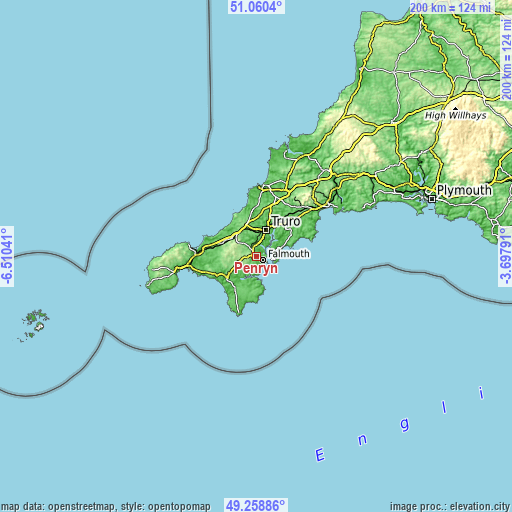
| \ | Map #1 | Map #2 | Topo.Map |
| Scale [m] | -4..184 m | -4..205 m | × |
| Scale [ft] | -13..604 ft | -13..673 ft | × |
| Average | 72.5 m = 238 ft | 80.5 m = 264 ft | × |
| Width | 6.26 km = 3.9 mi | 12.52 km = 7.8 mi | 200.3 km = 124.5 mi |
| Height | 6.26 km = 3.9 mi | 12.52 km = 7.8 mi | 200.3 km = 124.5 mi |
| ↑Max Latitude | 50.19626° | 50.224384° | 51.0604° |
| Latitude at center | 50.16812° | 50.16812° | 50.16812° |
| ↓Min Latitude | 50.139963° | 50.11179° | 49.25886° |
| ← Min Longitude | -5.148105° | -5.192051° | -6.51041° |
| Longitude center | -5.10416° | -5.10416° | -5.10416° |
| →Max Longitude | -5.060215° | -5.016269° | -3.69791° |
Nearby cities:
Cities around Penryn sort by population:
• Redruth elevation 135 m
11.2 km,  310°
310°
• Falmouth 34 m
2.8 km,  122°
122°
• Truro 15 m
11.4 km,  18°
18°
• Portscatho 30 m
9.3 km,  86°
86°
• Stithians 134 m
5.7 km,  293°
293°
• Mylor Bridge 9 m
2.6 km,  42°
42°
• Four Lanes 216 m
10.4 km, 291°
• Chacewater 61 m
10.6 km,  338°
338°
• Perranwell 22 m
5.2 km,  346°
346°
• St. Day 128 m
9.8 km,  323°
323°
• Wendron 135 m
11.1 km,  249°
249°
• Perranarworthal 33 m
4.3 km, 344°
Multilingual:
 En español:
Penryn elevación 29 m.
 En France:
Penryn élévation 29 m.


Sources and notes:
- [note 1] Map square and city borders are not equal. Map elevation data is calculated only from area inside that square.
- [src 1] Elevation data from geonames database provided with same terms of usage.
- [src 2] The elevation map of Penryn is generated using elevation data from NASA's 3 arcsec (90m) resolution SRTM data.
- [src 3] Base (background) map © OpenStreetMap contributors tiles are generated by Geofabrik and OpenTopoMap.
Copyright & License:
This Penryn Elevation Map is licensed under CC BY-SA. You may reuse any part from this page, if you give a proper credit by linking to this URL:
 More info on terms of use page.