Peover Superior elevation
Peover Superior (England, Cheshire East), United Kingdom elevation is 65 meters and Peover Superior elevation in feet is 213 ft above sea level [src 1]. Peover Superior is a seat of a third-order administrative division (feature code) with elevation that is 7 meters (23 ft) smaller than average city elevation in United Kingdom.
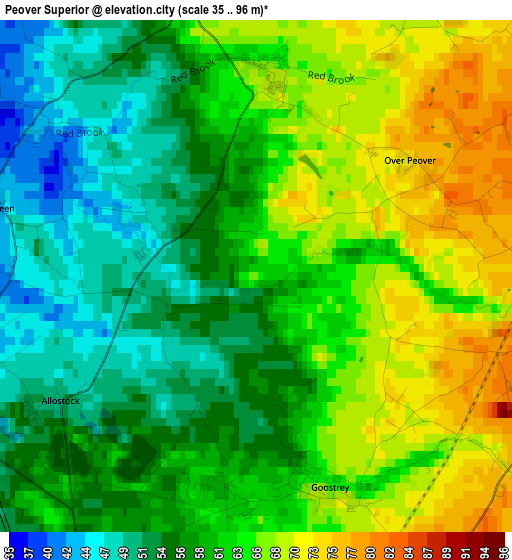
Below is the Elevation map of Peover Superior, which displays elevation range with different colors. Scale of the first map is from 35 to 96 m (115 to 315 ft) with average elevation of 60.6 meters (=199 ft) [note 1]
These maps also provides idea of topography and contour of this city, they are displayed at different zoom levels. More info about maps, scale and edge coordinates you can find below images.
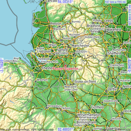
| \ | Map #1 | Topo.Map |
| Scale [m] | 35..96 m | × |
| Scale [ft] | 115..315 ft | × |
| Average | 60.6 m = 199 ft | × |
| Width | 5.85 km = 3.6 mi | 187.1 km = 116.3 mi |
| Height | 5.85 km = 3.6 mi | 187.1 km = 116.3 mi |
| ↑Max Latitude | 53.276285° | 54.08315° |
| Latitude at center | 53.25° | 53.25° |
| ↓Min Latitude | 53.223698° | 52.40031° |
| ← Min Longitude | -2.393945° | -3.75625° |
| Longitude center | -2.35° | -2.35° |
| →Max Longitude | -2.306055° | -0.94375° |
Nearby cities:
Cities around Peover Superior sort by population:
• Northwich elevation 36 m
11.4 km,  274°
274°
• Middlewich 30 m
8.9 km,  224°
224°
• Knutsford 68 m
6.1 km,  344°
344°
• Holmes Chapel 62 m
5.4 km,  185°
185°
• Alderley Edge 87 m
9.6 km,  51°
51°
• Mobberley 58 m
7.7 km,  16°
16°
• Goostrey 68 m
2.6 km,  164°
164°
• Chelford 78 m
5 km,  62°
62°
• Ashley 46 m
11.2 km,  5°
5°
• Marston 16 m
10.1 km,  280°
280°
• Mere 72 m
9.9 km, 336°
• Siddington 99 m
8 km,  103°
103°
Multilingual:
 En español:
Peover Superior elevación 65 m.
 En France:
Peover Superior élévation 65 m.
 Auf Deutsch:
Peover Superior höhe über dem Meeresspiegel ist 65 m.

Sources and notes:
- [note 1] Map square and city borders are not equal. Map elevation data is calculated only from area inside that square.
- [src 1] Elevation data from geonames database provided with same terms of usage.
- [src 2] The elevation map of Peover Superior is generated using elevation data from NASA's 3 arcsec (90m) resolution SRTM data.
- [src 3] Base (background) map © OpenStreetMap contributors tiles are generated by Geofabrik and OpenTopoMap.
Copyright & License:
This Peover Superior Elevation Map is licensed under CC BY-SA. You may reuse any part from this page, if you give a proper credit by linking to this URL:
 More info on terms of use page.