Rainford elevation
Rainford (England, St. Helens), United Kingdom elevation is 44 meters and Rainford elevation in feet is 144 ft above sea level [src 1]. Rainford is a populated place (feature code) with elevation that is 28 meters (92 ft) smaller than average city elevation in United Kingdom.
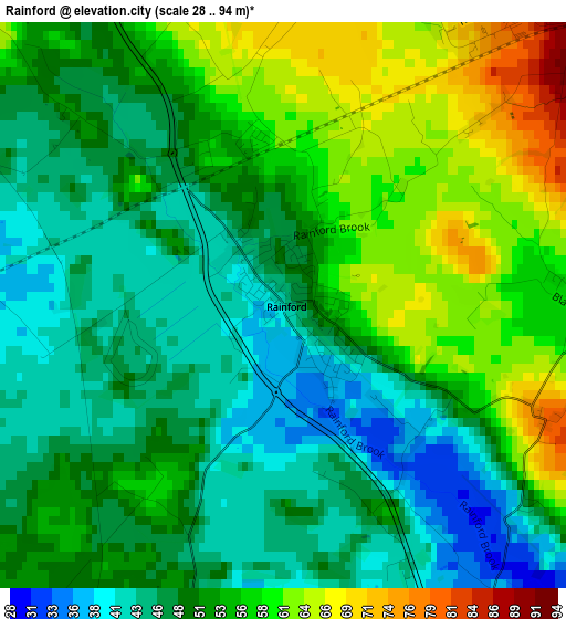
Below is the Elevation map of Rainford, which displays elevation range with different colors. Scale of the first map is from 28 to 94 m (92 to 308 ft) with average elevation of 51.6 meters (=169 ft) [note 1]
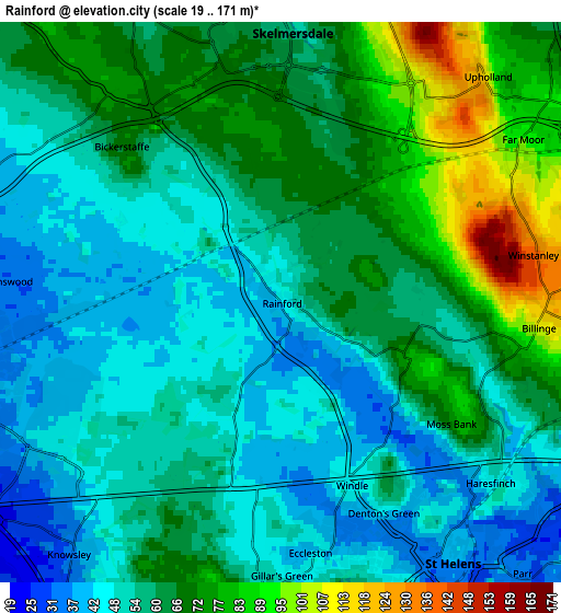
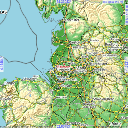
These maps also provides idea of topography and contour of this city, they are displayed at different zoom levels. More info about maps, scale and edge coordinates you can find below images.
| \ | Map #1 | Map #2 | Topo.Map |
| Scale [m] | 28..94 m | 19..171 m | × |
| Scale [ft] | 92..308 ft | 62..561 ft | × |
| Average | 51.6 m = 169 ft | 59.9 m = 197 ft | × |
| Width | 5.81 km = 3.6 mi | 11.63 km = 7.2 mi | 186 km = 115.6 mi |
| Height | 5.81 km = 3.6 mi | 11.63 km = 7.2 mi | 186 km = 115.6 mi |
| ↑Max Latitude | 53.52836° | 53.554474° | 54.33043° |
| Latitude at center | 53.50223° | 53.50223° | 53.50223° |
| ↓Min Latitude | 53.476084° | 53.449921° | 52.65753° |
| ← Min Longitude | -2.832335° | -2.876281° | -4.19464° |
| Longitude center | -2.78839° | -2.78839° | -2.78839° |
| →Max Longitude | -2.744445° | -2.700499° | -1.38214° |
Nearby cities:
Cities around Rainford sort by population:
• St Helens elevation 31 m
6.9 km,  147°
147°
• Kirkby 25 m
7.2 km,  251°
251°
• Prescot 81 m
8.1 km,  185°
185°
• Skelmersdale 71 m
5.4 km,  10°
10°
• Ashton in Makerfield 64 m
9.4 km,  102°
102°
• Haydock 41 m
8.1 km,  118°
118°
• Billinge 111 m
5.3 km, 95°
• Appley Bridge 21 m
9.5 km,  27°
27°
• Whiston 62 m
9.1 km,  180°
180°
• Melling 19 m
8.7 km,  256°
256°
• Knowsley 33 m
6.9 km,  218°
218°
• Eccleston 45 m
5.8 km, 176°
Multilingual:
 En español:
Rainford elevación 44 m.
 En France:
Rainford élévation 44 m.


Sources and notes:
- [note 1] Map square and city borders are not equal. Map elevation data is calculated only from area inside that square.
- [src 1] Elevation data from geonames database provided with same terms of usage.
- [src 2] The elevation map of Rainford is generated using elevation data from NASA's 3 arcsec (90m) resolution SRTM data.
- [src 3] Base (background) map © OpenStreetMap contributors tiles are generated by Geofabrik and OpenTopoMap.
Copyright & License:
This Rainford Elevation Map is licensed under CC BY-SA. You may reuse any part from this page, if you give a proper credit by linking to this URL:
 More info on terms of use page.