Rhondda elevation
Rhondda (Wales, Rhondda Cynon Taf), United Kingdom elevation is 256 meters and Rhondda elevation in feet is 840 ft above sea level [src 1]. Rhondda is a populated place (feature code) with elevation that is 184 meters (604 ft) bigger than average city elevation in United Kingdom.
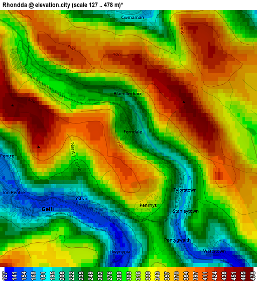
Below is the Elevation map of Rhondda, which displays elevation range with different colors. Scale of the first map is from 127 to 478 m (417 to 1568 ft) with average elevation of 314.2 meters (=1031 ft) [note 1]
These maps also provides idea of topography and contour of this city, they are displayed at different zoom levels. More info about maps, scale and edge coordinates you can find below images.
| \ | Map #1 | Map #2 | Topo.Map |
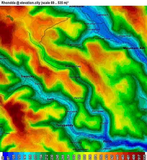
| Scale [m] | 127..478 m | 69..535 m | × |
| Scale [ft] | 417..1568 ft | 226..1755 ft | × |
| Average | 314.2 m = 1031 ft | 297 m = 974 ft | × |
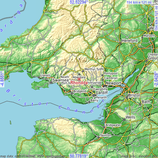
| Width | 6.06 km = 3.8 mi | 12.12 km = 7.5 mi | 194 km = 120.5 mi |
| Height | 6.06 km = 3.8 mi | 12.12 km = 7.5 mi | 194 km = 120.5 mi |
| ↑Max Latitude | 51.686213° | 51.713449° | 52.52294° |
| Latitude at center | 51.65896° | 51.65896° | 51.65896° |
| ↓Min Latitude | 51.631691° | 51.604405° | 50.77819° |
| ← Min Longitude | -3.492795° | -3.536741° | -4.8551° |
| Longitude center | -3.44885° | -3.44885° | -3.44885° |
| →Max Longitude | -3.404905° | -3.360959° | -2.0426° |
Nearby cities:
Cities around Rhondda sort by population:
• Tonypandy elevation 154 m
4.1 km,  186°
186°
• Aberdare 135 m
6.2 km,  359°
359°
• Mountain Ash 116 m
5.5 km,  59°
59°
• Treorchy 161 m
3.9 km,  271°
271°
• Ferndale 236 m
0.2 km,  27°
27°
• Pentre 165 m
3 km,  259°
259°
• Cwmbach 174 m
5.9 km, 27°
• Llwynypia 142 m
2.9 km,  181°
181°
• Porth 147 m
6 km,  148°
148°
• Treherbert 187 m
5.7 km,  283°
283°
• Clydach Vale 249 m
4.2 km,  211°
211°
• Maerdy 307 m
3.2 km,  304°
304°
Multilingual:
 En español:
Rhondda elevación 256 m.
 En France:
Rhondda élévation 256 m.


Sources and notes:
- [note 1] Map square and city borders are not equal. Map elevation data is calculated only from area inside that square.
- [src 1] Elevation data from geonames database provided with same terms of usage.
- [src 2] The elevation map of Rhondda is generated using elevation data from NASA's 3 arcsec (90m) resolution SRTM data.
- [src 3] Base (background) map © OpenStreetMap contributors tiles are generated by Geofabrik and OpenTopoMap.
Copyright & License:
This Rhondda Elevation Map is licensed under CC BY-SA. You may reuse any part from this page, if you give a proper credit by linking to this URL:
 More info on terms of use page.