Rothienorman elevation
Rothienorman (Scotland, Aberdeenshire), United Kingdom elevation is 119 meters and Rothienorman elevation in feet is 390 ft above sea level [src 1]. Rothienorman is a populated place (feature code) with elevation that is 47 meters (154 ft) bigger than average city elevation in United Kingdom.
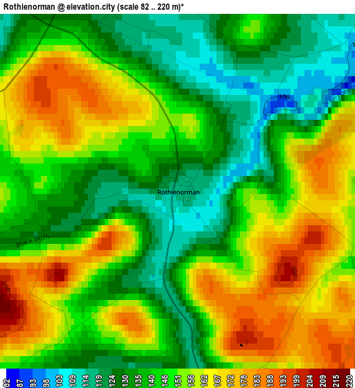
Below is the Elevation map of Rothienorman, which displays elevation range with different colors. Scale of the first map is from 82 to 220 m (269 to 722 ft) with average elevation of 147.4 meters (=484 ft) [note 1]
These maps also provides idea of topography and contour of this city, they are displayed at different zoom levels. More info about maps, scale and edge coordinates you can find below images.
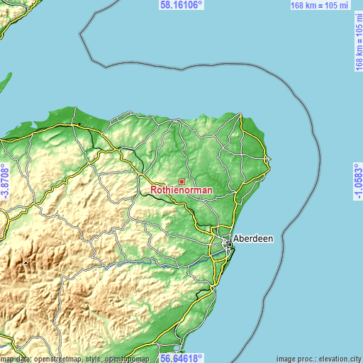
| \ | Map #1 | Topo.Map |
| Scale [m] | 82..220 m | × |
| Scale [ft] | 269..722 ft | × |
| Average | 147.4 m = 484 ft | × |
| Width | 5.26 km = 3.3 mi | 168.4 km = 104.6 mi |
| Height | 5.26 km = 3.3 mi | 168.4 km = 104.6 mi |
| ↑Max Latitude | 57.435111° | 58.16106° |
| Latitude at center | 57.41145° | 57.41145° |
| ↓Min Latitude | 57.387773° | 56.64618° |
| ← Min Longitude | -2.508495° | -3.8708° |
| Longitude center | -2.46455° | -2.46455° |
| →Max Longitude | -2.420605° | -1.0583° |
Nearby cities:
Cities around Rothienorman sort by population:
• Inverurie elevation 63 m
15.1 km,  159°
159°
• Ellon 12 m
24 km,  102°
102°
• Turriff 55 m
14.1 km,  1°
1°
• Huntly 127 m
19.7 km,  281°
281°
• Kintore 51 m
20.7 km, 159°
• Kemnay 88 m
19.6 km,  176°
176°
• Oldmeldrum 116 m
12.1 km,  134°
134°
• Newmacher 99 m
23.3 km, 133°
• Insch 129 m
11.7 km,  229°
229°
• Alford 149 m
24.5 km,  215°
215°
• Pitmedden 62 m
19 km,  115°
115°
• Aberchirder 144 m
19.2 km,  329°
329°
Multilingual:
 En español:
Rothienorman elevación 119 m.
 En France:
Rothienorman élévation 119 m.
 Auf Deutsch:
Rothienorman höhe über dem Meeresspiegel ist 119 m.

Sources and notes:
- [note 1] Map square and city borders are not equal. Map elevation data is calculated only from area inside that square.
- [src 1] Elevation data from geonames database provided with same terms of usage.
- [src 2] The elevation map of Rothienorman is generated using elevation data from NASA's 3 arcsec (90m) resolution SRTM data.
- [src 3] Base (background) map © OpenStreetMap contributors tiles are generated by Geofabrik and OpenTopoMap.
Copyright & License:
This Rothienorman Elevation Map is licensed under CC BY-SA. You may reuse any part from this page, if you give a proper credit by linking to this URL:
 More info on terms of use page.